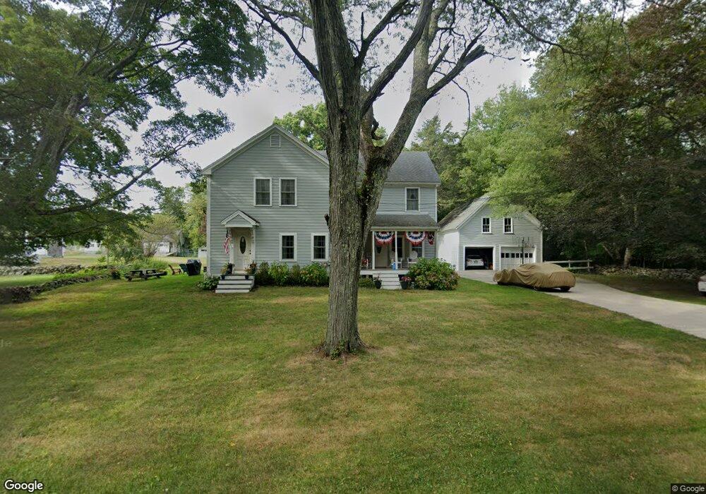
51 Baker Rd Swansea, MA 02777
Northeast Swansea NeighborhoodEstimated Value: $675,785 - $961,000
3
Beds
3
Baths
2,838
Sq Ft
$286/Sq Ft
Est. Value
About This Home
This home is located at 51 Baker Rd, Swansea, MA 02777 and is currently estimated at $811,446, approximately $285 per square foot. 51 Baker Rd is a home located in Bristol County with nearby schools including Joseph Case High School, SCEC Life Academy, and Swansea Wood School.
Ownership History
Date
Name
Owned For
Owner Type
Purchase Details
Closed on
Aug 7, 1998
Sold by
Eddy Robert J and Eddy Joyce A
Bought by
Mills Leonard
Current Estimated Value
Purchase Details
Closed on
Feb 6, 1998
Sold by
Eddy Robert J and Eddy Joyce A
Bought by
Mello Damian W and Best-Mello Mary A
Purchase Details
Closed on
Oct 29, 1997
Sold by
Eddy Robert J and Eddy Joyce A
Bought by
Lcl Constr Inc
Purchase Details
Closed on
Aug 26, 1988
Sold by
Walkden Marion B
Bought by
Eddy Robert J
Create a Home Valuation Report for This Property
The Home Valuation Report is an in-depth analysis detailing your home's value as well as a comparison with similar homes in the area
Home Values in the Area
Average Home Value in this Area
Purchase History
| Date | Buyer | Sale Price | Title Company |
|---|---|---|---|
| Mills Leonard | $51,000 | -- | |
| Mills Leonard | $51,000 | -- | |
| Mello Damian W | $270,000 | -- | |
| Mello Damian W | $270,000 | -- | |
| Lcl Constr Inc | $41,000 | -- | |
| Eddy Robert J | $300,000 | -- |
Source: Public Records
Mortgage History
| Date | Status | Borrower | Loan Amount |
|---|---|---|---|
| Open | Eddy Robert J | $17,500 | |
| Open | Eddy Robert J | $300,700 |
Source: Public Records
Tax History Compared to Growth
Tax History
| Year | Tax Paid | Tax Assessment Tax Assessment Total Assessment is a certain percentage of the fair market value that is determined by local assessors to be the total taxable value of land and additions on the property. | Land | Improvement |
|---|---|---|---|---|
| 2025 | -- | $524,000 | $181,000 | $343,000 |
| 2024 | -- | $522,000 | $181,000 | $341,000 |
| 2023 | $0 | $421,800 | $133,900 | $287,900 |
| 2022 | $0 | $350,100 | $121,800 | $228,300 |
| 2021 | $0 | $332,100 | $121,400 | $210,700 |
| 2020 | $0 | $325,200 | $121,400 | $203,800 |
| 2019 | $0 | $326,700 | $108,700 | $218,000 |
| 2018 | $0 | $353,700 | $145,500 | $208,200 |
| 2017 | $0 | $357,700 | $145,600 | $212,100 |
| 2016 | -- | $283,800 | $83,500 | $200,300 |
| 2015 | -- | $281,600 | $83,500 | $198,100 |
| 2014 | $6,528 | $278,500 | $78,200 | $200,300 |
Source: Public Records
Map
Nearby Homes
- 48 Laurie Ln
- 2660 Courtlyn Rd
- 35 Clubhouse Dr Unit RR35
- RR33 Club House Dr Unit Lot RR33
- 3064 Clubhouse Dr
- 3094 Millers Ln
- 3035 Clubhouse Dr Unit 6
- 3035 Clubhouse Dr Unit 8
- 3049 Clubhouse Dr Unit 77
- 3035 Clubhouse Dr Unit 2
- 3055 Clubhouse Dr Unit 80
- 3035 Clubhouse Dr
- 3035 Clubhouse Dr Unit 4
- 3035 Clubhouse Dr Unit 1
- 3051 Clubhouse Dr Unit 78
- 3035 Clubhouse Dr Unit 3
- 3035 Clubhouse Dr Unit 7
- 3035 Clubhouse Dr Unit 5
- 3045 Clubhouse Dr Unit Lot 75
- 3057 Clubhouse Dr
- 9 Baker Rd
- 0 Sharps Lot Rd (Es)
- 0 Sharps Lot Rd
- 00 Sharps Lot Rd
- 0 Sharps Lot Rd (Ws)
- 0 Sharps Lot Rd Unit 805528
- 0 Sharps Lot Rd Unit 914942
- 0 Sharps Lot Rd Unit 716390
- 0 Sharps Lot Rd Unit 739659
- 0 Sharps Lot Rd Unit 739661
- 0 Sharps Lot Rd Unit 706743
- 0 Sharps Lot Rd Unit 716391
- 0 Sharps Lot Rd Unit 70559954
- 0 Sharps Lot Rd Unit 70351328
- 0 Sharps Lot Rd Unit 70302711
- 0 Sharps Lot Rd Unit 830540
- 0 Sharps Lot Rd Unit 830547
- 0 Sharps Lot Rd Unit 938316
- 0 Sharps Lot Rd Unit 938319
- 0 Sharps Lot Rd Unit 1048303