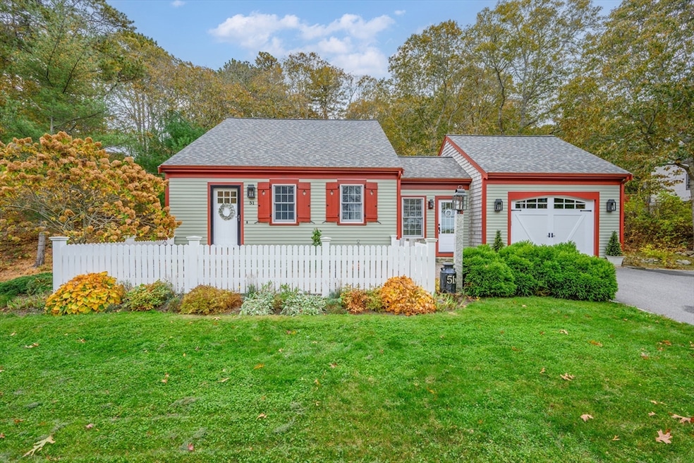
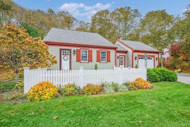
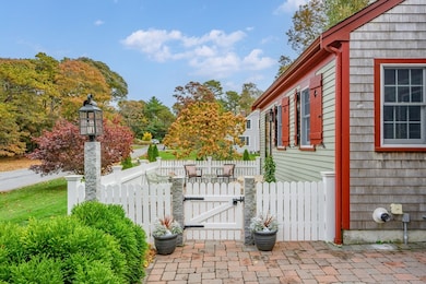
51 Bray Farm Rd N Yarmouth Port, MA 02675
Yarmouth Port NeighborhoodEstimated payment $4,721/month
Highlights
- Open Floorplan
- Landscaped Professionally
- Wood Flooring
- Cape Cod Architecture
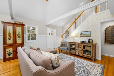
- Cathedral Ceiling
- Main Floor Primary Bedroom
About This Home
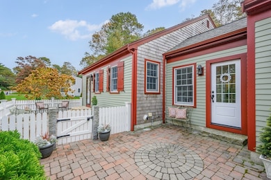
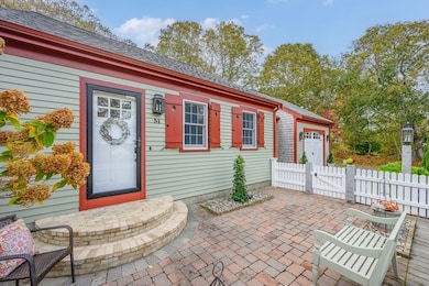
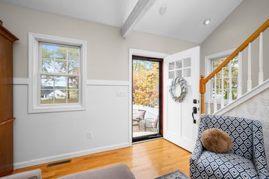
Welcome to 51 Bray Farm Road N, blending classic Cape Cod charm with modern comfort and an unbeatable location. With serene marsh views from the front, the exterior features new shingles, Azek trim, new retaining wall and new roof, creating timeless curb appeal. Inside, the home feels bright and comfortable. With gas heat, central air and a tankless water heater, it's designed for efficient year-round living. The floor plan balances coastal charm with updates that make life easy. The first-floor primary bedroom suite offers the convenience of single-level living. The sunlit living room, inviting dining area, and a well-equipped kitchen make entertaining or quiet evenings effortless. The enclosed breezeway connects the house to the one-car garage and offers flexible space to enjoy in every season. The finished lower level adds additional living space, complete with heat, ac, full bath, and walk-out access, presenting tremendous flexibility. This home is designed for easy Cape Cod living
Home Details
Home Type
- Single Family
Est. Annual Taxes
- $4,267
Year Built
- Built in 1984
Lot Details
- 0.43 Acre Lot
- Landscaped Professionally
- Level Lot
Parking
- 1 Car Attached Garage
- Parking Storage or Cabinetry
- Open Parking
Home Design
- Cape Cod Architecture
- Shingle Roof
- Concrete Perimeter Foundation
Interior Spaces
- Open Floorplan
- Cathedral Ceiling
- Ceiling Fan
- Skylights
- Recessed Lighting
Kitchen
- Range
- Microwave
- Dishwasher
- Kitchen Island
- Solid Surface Countertops
Flooring
- Wood
- Wall to Wall Carpet
- Laminate
- Tile
Bedrooms and Bathrooms
- 3 Bedrooms
- Primary Bedroom on Main
- Bathtub with Shower
- Separate Shower
Laundry
- Dryer
- Washer
Finished Basement
- Walk-Out Basement
- Basement Fills Entire Space Under The House
- Interior Basement Entry
- Laundry in Basement
Outdoor Features
- Outdoor Shower
- Patio
- Rain Gutters
Utilities
- Ductless Heating Or Cooling System
- Forced Air Heating and Cooling System
- 2 Cooling Zones
- 1 Heating Zone
- Heating System Uses Natural Gas
- Gas Water Heater
- Private Sewer
Listing and Financial Details
- Assessor Parcel Number M:0151 B:00055 L:0000,2428333
Community Details
Overview
- No Home Owners Association
- Near Conservation Area
Recreation
- Bike Trail
Map
Home Values in the Area
Average Home Value in this Area
Tax History
| Year | Tax Paid | Tax Assessment Tax Assessment Total Assessment is a certain percentage of the fair market value that is determined by local assessors to be the total taxable value of land and additions on the property. | Land | Improvement |
|---|---|---|---|---|
| 2025 | $4,267 | $602,700 | $171,000 | $431,700 |
| 2024 | $3,958 | $536,300 | $148,800 | $387,500 |
| 2023 | $3,746 | $461,900 | $135,200 | $326,700 |
| 2022 | $3,454 | $376,300 | $129,000 | $247,300 |
| 2021 | $3,400 | $355,600 | $129,000 | $226,600 |
| 2020 | $3,362 | $336,200 | $136,600 | $199,600 |
| 2019 | $3,155 | $312,400 | $136,600 | $175,800 |
| 2018 | $2,980 | $289,600 | $113,800 | $175,800 |
| 2017 | $2,902 | $289,600 | $113,800 | $175,800 |
| 2016 | $2,799 | $280,500 | $104,700 | $175,800 |
| 2015 | $2,629 | $261,900 | $100,100 | $161,800 |
Property History
| Date | Event | Price | List to Sale | Price per Sq Ft |
|---|---|---|---|---|
| 11/16/2025 11/16/25 | Pending | -- | -- | -- |
| 11/12/2025 11/12/25 | For Sale | $829,000 | -- | $720 / Sq Ft |
Purchase History
| Date | Type | Sale Price | Title Company |
|---|---|---|---|
| Deed | $330,000 | -- | |
| Deed | $265,000 | -- |
Mortgage History
| Date | Status | Loan Amount | Loan Type |
|---|---|---|---|
| Open | $313,500 | Purchase Money Mortgage | |
| Previous Owner | $265,000 | No Value Available | |
| Previous Owner | $50,000 | No Value Available |
Source: MLS Property Information Network (MLS PIN)
MLS Number: 73450884
APN: YARM-000151-000055
Disclaimer: Certain information contained herein is derived from information provided by parties other than Homes.com. All information provided is deemed reliable, but is not guaranteed to be accurate and should be independently verified.
![]() The property listing data and information, or the Images, set forth herein were provided to MLS Property Information Network, Inc. from third party sources, including sellers, lessors and public records, and were compiled by MLS Property Information Network, Inc. The property listing data and information, and the Images, are for the personal, non-commercial use of consumers having a good faith interest in purchasing or leasing listed properties of the type displayed to them and may not be used for any purpose other than to identify prospective properties which such consumers may have a good faith interest in purchasing or leasing. MLS Property Information Network, Inc. and its subscribers disclaim any and all representations and warranties as to the accuracy of the property listing data and information, or as to the accuracy of any of the Images, set forth herein.
The property listing data and information, or the Images, set forth herein were provided to MLS Property Information Network, Inc. from third party sources, including sellers, lessors and public records, and were compiled by MLS Property Information Network, Inc. The property listing data and information, and the Images, are for the personal, non-commercial use of consumers having a good faith interest in purchasing or leasing listed properties of the type displayed to them and may not be used for any purpose other than to identify prospective properties which such consumers may have a good faith interest in purchasing or leasing. MLS Property Information Network, Inc. and its subscribers disclaim any and all representations and warranties as to the accuracy of the property listing data and information, or as to the accuracy of any of the Images, set forth herein.
- 59 Main St Unit 19-2
- 59 Route 6a Unit 29-4
- 268 Main St
- 42 John Hall Cartway Unit 42
- 50 John Hall Cartway
- 50 John Hall Cartway Unit 50
- 64 Kates Path
- 228 Kates Path
- 34 Kates Path
- 34 Kates Path Unit 34
- 17 Kates Path Unit A
- 44 Stratford Ln
- 6 Nimble Hill Dr
- 43 Canterbury Rd
- 7 Forest Gate Unit 7
- 30 W Woods
- 30 W Woods Cir Unit 30
- 6 Thomas Ct
- 15 Signal Hill Dr
- 28 Oak Glen
