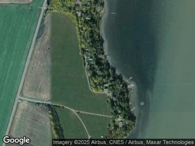
51 Cedar Point Way Crown Point, NY 12928
Estimated Value: $304,000 - $724,000
2
Beds
1
Bath
1,120
Sq Ft
$386/Sq Ft
Est. Value
About This Home
This home is located at 51 Cedar Point Way, Crown Point, NY 12928 and is currently estimated at $431,780, approximately $385 per square foot. 51 Cedar Point Way is a home located in Essex County with nearby schools including Crown Point Central School.
Ownership History
Date
Name
Owned For
Owner Type
Purchase Details
Closed on
Sep 9, 2021
Sold by
Bruce Robert R and Bruce Anna C
Bought by
Bruce Jason C and Bruce Justin R
Current Estimated Value
Purchase Details
Closed on
Jul 6, 2018
Sold by
Bruce Robert R and Bruce Anna C
Bought by
Bruce Robert R and Bruce Anna C
Purchase Details
Closed on
Jun 3, 2008
Sold by
Walters Wendy Davis
Bought by
Bruce Robert R Anna C
Create a Home Valuation Report for This Property
The Home Valuation Report is an in-depth analysis detailing your home's value as well as a comparison with similar homes in the area
Home Values in the Area
Average Home Value in this Area
Purchase History
| Date | Buyer | Sale Price | Title Company |
|---|---|---|---|
| Bruce Jason C | -- | None Available | |
| Bruce Jason C | -- | None Available | |
| Bruce Robert R | -- | -- | |
| Bruce Robert R Anna C | $30,000 | Randolph Parbu | |
| Bruce Robert R Anna C | $30,000 | Randolph Parbu |
Source: Public Records
Tax History Compared to Growth
Tax History
| Year | Tax Paid | Tax Assessment Tax Assessment Total Assessment is a certain percentage of the fair market value that is determined by local assessors to be the total taxable value of land and additions on the property. | Land | Improvement |
|---|---|---|---|---|
| 2024 | $4,583 | $223,300 | $54,100 | $169,200 |
| 2023 | $4,555 | $223,300 | $54,100 | $169,200 |
| 2022 | $4,493 | $223,300 | $54,100 | $169,200 |
| 2021 | $4,507 | $208,700 | $54,100 | $154,600 |
| 2020 | $4,010 | $208,700 | $54,100 | $154,600 |
| 2019 | $3,973 | $208,700 | $54,100 | $154,600 |
| 2018 | $4,273 | $216,000 | $54,100 | $161,900 |
| 2017 | $4,101 | $216,000 | $54,100 | $161,900 |
| 2016 | $4,095 | $216,000 | $54,100 | $161,900 |
| 2015 | -- | $216,000 | $54,100 | $161,900 |
| 2014 | -- | $153,700 | $35,800 | $117,900 |
Source: Public Records
Map
Nearby Homes
- L13.100 Lake Rd
- 17 Old Port Way
- 3139 Lake St
- 12 Berry Patch Way
- 19 Porter Mill Rd
- 29 Park Ave
- 15 Champlain Shores Way
- 2776 Main St
- 2073 Creek Rd
- 0 Bridge Rd Unit 11348779
- 0 Bridge Rd Unit 203137
- L9 Cold Spring Rd
- 113 Captains Cove
- 237 Holstein Dr
- 6.000 Lang Rd
- 0 Crown Point Rd
- 60 Cedar Dr
- 24 Meacham St
- 11 Jackson St
- 100 Sam Curran Rd
