
Seller's Agent in 2025
Carson Helminiak
Key Realty LTD
(419) 508-7144
8 in this area
101 Total Sales
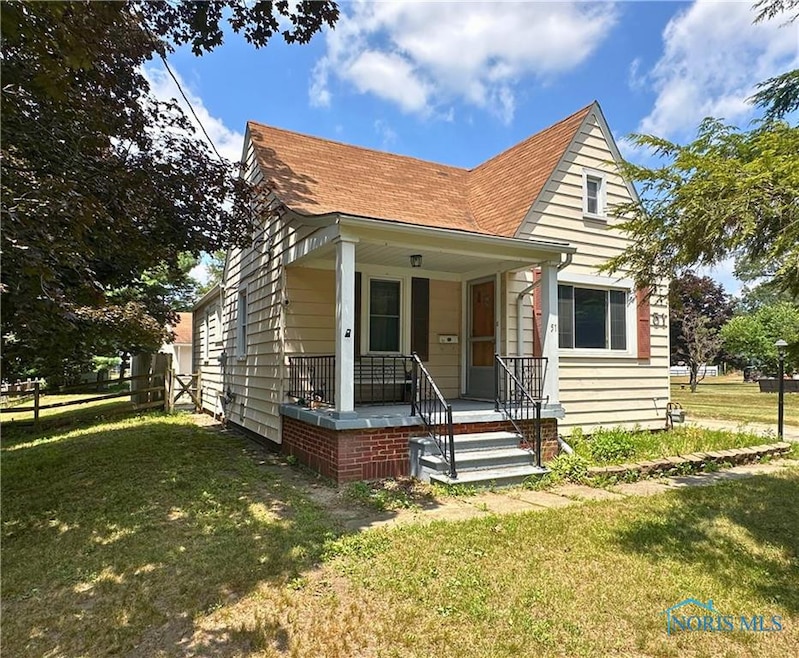


This wonderful home is ready for you to move in! Featuring 3 bedrooms, 2 full bathrooms with a new kitchen counter, sink and under-cabinet lighting. All appliances stay! Step outside to your beautiful stone patio perfect for entertaining, along with a separate fenced-in area for added privacy. Additionally, the detached 2.5 car heated garage is equipped with new insulated doors and includes a workshop.Don't miss out on this opportunity—schedule your showing today!
Last Agent to Sell the Property
Key Realty LTD License #2007000186 Listed on: 07/09/2025
| Date | Type | Sale Price | Title Company |
|---|---|---|---|
| Warranty Deed | $175,100 | None Listed On Document | |
| Warranty Deed | $102,000 | Chicago Title Insurance Comp | |
| Deed | $55,000 | -- |
| Date | Status | Loan Amount | Loan Type |
|---|---|---|---|
| Open | $169,799 | New Conventional | |
| Previous Owner | $96,900 | Fannie Mae Freddie Mac |
| Date | Event | Price | List to Sale | Price per Sq Ft |
|---|---|---|---|---|
| 08/08/2025 08/08/25 | Sold | $175,051 | +0.1% | $103 / Sq Ft |
| 07/09/2025 07/09/25 | For Sale | $174,900 | -- | $103 / Sq Ft |
| Year | Tax Paid | Tax Assessment Tax Assessment Total Assessment is a certain percentage of the fair market value that is determined by local assessors to be the total taxable value of land and additions on the property. | Land | Improvement |
|---|---|---|---|---|
| 2025 | -- | $31,920 | $8,715 | $23,205 |
| 2024 | $1,092 | $31,920 | $8,715 | $23,205 |
| 2023 | $1,956 | $26,985 | $7,875 | $19,110 |
| 2022 | $1,929 | $26,985 | $7,875 | $19,110 |
| 2021 | $1,998 | $26,985 | $7,875 | $19,110 |
| 2020 | $1,925 | $22,155 | $6,475 | $15,680 |
| 2019 | $1,846 | $22,155 | $6,475 | $15,680 |
| 2018 | $1,885 | $22,155 | $6,475 | $15,680 |
| 2017 | $1,841 | $21,560 | $8,890 | $12,670 |
| 2016 | $1,874 | $61,600 | $25,400 | $36,200 |
| 2015 | $1,911 | $61,600 | $25,400 | $36,200 |
| 2014 | $1,356 | $21,560 | $8,890 | $12,670 |
| 2013 | $1,356 | $21,560 | $8,890 | $12,670 |
Seller's Agent in 2025
Carson Helminiak
Key Realty LTD
(419) 508-7144
8 in this area
101 Total Sales
D
Seller Co-Listing Agent in 2025
Danielle Helminiak
Key Realty LTD
(419) 508-7144
3 in this area
43 Total Sales
J
Buyer's Agent in 2025
Julie Wood
The Danberry Co.
(419) 460-8454
14 in this area
97 Total Sales
Source: Northwest Ohio Real Estate Information Service (NORIS)
MLS Number: 6132485
APN: 20-48614
Disclaimer: Certain information contained herein is derived from information provided by parties other than Homes.com. All information provided is deemed reliable, but is not guaranteed to be accurate and should be independently verified.
![]() IDX information is provided exclusively for personal, non-commercial use, and may not be used for any purpose other than to identify prospective properties consumers may be interested in purchasing. Information is deemed reliable but not guaranteed. ©2026 NORIS. All rights reserved.
IDX information is provided exclusively for personal, non-commercial use, and may not be used for any purpose other than to identify prospective properties consumers may be interested in purchasing. Information is deemed reliable but not guaranteed. ©2026 NORIS. All rights reserved.
Ask me questions while you tour the home.