
Seller's Agent in 2025
Dara Singleton
Better Homes and Gardens Real Estate - The Shanahan Group
(917) 334-4200
1 in this area
56 Total Sales


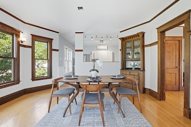


Gracefully situated on a sun-drenched corner in a quiet residential neighborhood mere moments from vibrant Davis Square, this exceptional three-bedroom, two-bath condominium blends timeless architectural charm with modern comfort. Original woodwork, many built-ins, a decorative fireplace and clawfoot tub create an atmosphere of warmth and character, while bay windows and a southwest exposure flood the interior with natural light. The open floor plan flows seamlessly across two living levels, with living, dining, kitchen, two bedrooms and a full bath on the main level. Upstairs, the expansive primary suite offers a serene retreat with skylights, walk-in closets and a second full bath. A spacious deck invites outdoor gatherings and central air adds year-round comfort. Abundant storage - several generous closets throughout, additional basement space and laundry enhance the convenience of this distinctive and beautifully maintained home in this highly sought-after location.
Last Agent to Sell the Property
Better Homes and Gardens Real Estate - The Shanahan Group Listed on: 10/09/2025
| Date | Type | Sale Price | Title Company |
|---|---|---|---|
| Quit Claim Deed | $1,005,000 | -- | |
| Deed | -- | -- | |
| Quit Claim Deed | -- | -- | |
| Quit Claim Deed | -- | -- | |
| Deed | $420,000 | -- |
| Date | Status | Loan Amount | Loan Type |
|---|---|---|---|
| Open | $250,000 | New Conventional | |
| Previous Owner | $321,000 | New Conventional | |
| Previous Owner | $335,000 | No Value Available | |
| Previous Owner | $336,000 | Purchase Money Mortgage |
| Date | Event | Price | List to Sale | Price per Sq Ft |
|---|---|---|---|---|
| 11/19/2025 11/19/25 | Sold | $1,005,000 | +1.0% | $607 / Sq Ft |
| 10/14/2025 10/14/25 | Pending | -- | -- | -- |
| 10/09/2025 10/09/25 | For Sale | $995,000 | -- | $601 / Sq Ft |
| Year | Tax Paid | Tax Assessment Tax Assessment Total Assessment is a certain percentage of the fair market value that is determined by local assessors to be the total taxable value of land and additions on the property. | Land | Improvement |
|---|---|---|---|---|
| 2025 | $8,862 | $812,300 | $0 | $812,300 |
| 2024 | $8,275 | $786,600 | $0 | $786,600 |
| 2023 | $8,060 | $779,500 | $0 | $779,500 |
| 2022 | $7,455 | $732,300 | $0 | $732,300 |
| 2021 | $7,156 | $702,300 | $0 | $702,300 |
| 2020 | $6,956 | $689,400 | $0 | $689,400 |
| 2019 | $6,802 | $632,200 | $0 | $632,200 |
| 2018 | $7,100 | $627,800 | $0 | $627,800 |
| 2017 | $6,500 | $557,000 | $0 | $557,000 |
| 2016 | $6,816 | $544,000 | $0 | $544,000 |
| 2015 | $5,682 | $450,600 | $0 | $450,600 |
Seller's Agent in 2025
Dara Singleton
Better Homes and Gardens Real Estate - The Shanahan Group
(917) 334-4200
1 in this area
56 Total Sales
Buyer's Agent in 2025
Thalia Tringo
Thalia Tringo & Associates Real Estate, Inc.
(617) 513-1967
21 in this area
105 Total Sales
Source: MLS Property Information Network (MLS PIN)
MLS Number: 73441574
APN: SOME-000023-F000000-000010-000002
Disclaimer: Certain information contained herein is derived from information provided by parties other than Homes.com. All information provided is deemed reliable, but is not guaranteed to be accurate and should be independently verified.
![]() The property listing data and information, or the Images, set forth herein were provided to MLS Property Information Network, Inc. from third party sources, including sellers, lessors and public records, and were compiled by MLS Property Information Network, Inc. The property listing data and information, and the Images, are for the personal, non-commercial use of consumers having a good faith interest in purchasing or leasing listed properties of the type displayed to them and may not be used for any purpose other than to identify prospective properties which such consumers may have a good faith interest in purchasing or leasing. MLS Property Information Network, Inc. and its subscribers disclaim any and all representations and warranties as to the accuracy of the property listing data and information, or as to the accuracy of any of the Images, set forth herein.
The property listing data and information, or the Images, set forth herein were provided to MLS Property Information Network, Inc. from third party sources, including sellers, lessors and public records, and were compiled by MLS Property Information Network, Inc. The property listing data and information, and the Images, are for the personal, non-commercial use of consumers having a good faith interest in purchasing or leasing listed properties of the type displayed to them and may not be used for any purpose other than to identify prospective properties which such consumers may have a good faith interest in purchasing or leasing. MLS Property Information Network, Inc. and its subscribers disclaim any and all representations and warranties as to the accuracy of the property listing data and information, or as to the accuracy of any of the Images, set forth herein.