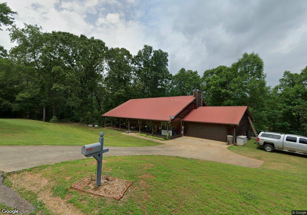
51 River Front Ln Carnesville, GA 30521
Estimated Value: $297,000 - $355,000
3
Beds
2
Baths
1,680
Sq Ft
$195/Sq Ft
Est. Value
About This Home
This home is located at 51 River Front Ln, Carnesville, GA 30521 and is currently estimated at $328,066, approximately $195 per square foot. 51 River Front Ln is a home located in Franklin County with nearby schools including Franklin County High School and Cornerstone Christian Academy.
Ownership History
Date
Name
Owned For
Owner Type
Purchase Details
Closed on
Aug 12, 2016
Sold by
Metz Robbie J C
Bought by
Tanner Christy Marie
Current Estimated Value
Home Financials for this Owner
Home Financials are based on the most recent Mortgage that was taken out on this home.
Original Mortgage
$139,650
Outstanding Balance
$110,599
Interest Rate
3.42%
Mortgage Type
New Conventional
Estimated Equity
$217,467
Purchase Details
Closed on
Nov 13, 1998
Bought by
Metz Delmus F and Metz Robb
Create a Home Valuation Report for This Property
The Home Valuation Report is an in-depth analysis detailing your home's value as well as a comparison with similar homes in the area
Purchase History
| Date | Buyer | Sale Price | Title Company |
|---|---|---|---|
| Tanner Christy Marie | $147,000 | -- | |
| Metz Delmus F | $108,800 | -- |
Source: Public Records
Mortgage History
| Date | Status | Borrower | Loan Amount |
|---|---|---|---|
| Open | Tanner Christy Marie | $139,650 |
Source: Public Records
Tax History
| Year | Tax Paid | Tax Assessment Tax Assessment Total Assessment is a certain percentage of the fair market value that is determined by local assessors to be the total taxable value of land and additions on the property. | Land | Improvement |
|---|---|---|---|---|
| 2025 | $2,383 | $103,134 | $20,000 | $83,134 |
| 2024 | $2,162 | $90,820 | $16,000 | $74,820 |
| 2023 | $2,168 | $84,018 | $16,000 | $68,018 |
| 2022 | $2,009 | $77,854 | $16,000 | $61,854 |
| 2021 | $1,715 | $62,324 | $9,600 | $52,724 |
| 2020 | $1,670 | $60,064 | $9,600 | $50,464 |
| 2019 | $1,614 | $60,064 | $9,600 | $50,464 |
| 2018 | $1,405 | $52,304 | $9,600 | $42,704 |
| 2017 | $1,461 | $52,304 | $9,600 | $42,704 |
| 2016 | $1,181 | $50,467 | $9,600 | $40,867 |
| 2015 | -- | $45,777 | $4,910 | $40,867 |
| 2014 | -- | $43,819 | $4,910 | $38,909 |
| 2013 | -- | $45,765 | $5,776 | $39,989 |
Source: Public Records
Map
Nearby Homes
- 597 Meadow Brook Ln
- 1350 Noah Crow Rd
- 0 Noah Crow Rd Unit 10692629
- 1898 Sandy Cross Rd
- 5177 Sandy Cross Rd
- 2394 W Main St
- 340 Riverbend Cir
- 0 New Franklin Church Rd
- 6.98 ACRES New Franklin Church Rd
- 6602 New Franklin Church Rd
- 1905 Bond Bridge Rd
- 329 Riverbend Dr
- 1321 Campbell Ridge Rd
- 206 College Heights
- 61 College Hgts Place
- 41 College Heights Place
- 23 College Heights Place
- 61 College Heights Place
- 41 College Heights
- 141 Carey St
- 84 River Front Ln
- 115 River Ridge Rd
- 150 River Ridge Rd Unit LOT 5
- 150 River Ridge Rd
- 150 River Ridge Rd
- 250 River Ridge Rd
- 130 River Front Ln
- 140 River Ridge Rd
- 300 River Ridge Rd
- 300 River Ridge Rd
- 121 River Ridge Rd
- 221 River Ridge Rd
- 239 River Ridge Dr
- 239 River Ridge Rd
- 304 River Ridge Rd
- 304 River Ridge Dr
- 305 River Ridge Rd
- 305 River Ridge Rd
- 277 River Ridge Rd
- 277 River Ridge Rd
Your Personal Tour Guide
Ask me questions while you tour the home.