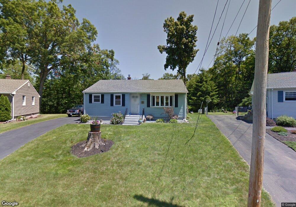
51 Viola Ln New Britain, CT 06053
Estimated Value: $244,000 - $299,595
2
Beds
2
Baths
1,098
Sq Ft
$255/Sq Ft
Est. Value
About This Home
This home is located at 51 Viola Ln, New Britain, CT 06053 and is currently estimated at $279,649, approximately $254 per square foot. 51 Viola Ln is a home located in Hartford County with nearby schools including Holmes School, Pulaski Middle School, and St. Francis of Assisi Middle School.
Ownership History
Date
Name
Owned For
Owner Type
Purchase Details
Closed on
Mar 26, 2002
Sold by
Webster Bank
Bought by
Sadlowski James J and Sadlowski Nancy A
Current Estimated Value
Home Financials for this Owner
Home Financials are based on the most recent Mortgage that was taken out on this home.
Original Mortgage
$60,000
Interest Rate
6.91%
Purchase Details
Closed on
Jan 28, 1997
Sold by
Dunn William Warren
Bought by
Sullivan Daniel H and Sullivan Jenny R
Home Financials for this Owner
Home Financials are based on the most recent Mortgage that was taken out on this home.
Original Mortgage
$61,600
Interest Rate
7.5%
Mortgage Type
Unknown
Purchase Details
Closed on
Oct 7, 1993
Sold by
Blaskey Bernice E
Bought by
Dunn William W
Home Financials for this Owner
Home Financials are based on the most recent Mortgage that was taken out on this home.
Original Mortgage
$50,000
Interest Rate
6.9%
Create a Home Valuation Report for This Property
The Home Valuation Report is an in-depth analysis detailing your home's value as well as a comparison with similar homes in the area
Home Values in the Area
Average Home Value in this Area
Purchase History
| Date | Buyer | Sale Price | Title Company |
|---|---|---|---|
| Sadlowski James J | $90,000 | -- | |
| Sullivan Daniel H | $77,000 | -- | |
| Dunn William W | $50,000 | -- |
Source: Public Records
Mortgage History
| Date | Status | Borrower | Loan Amount |
|---|---|---|---|
| Closed | Dunn William W | $60,000 | |
| Previous Owner | Dunn William W | $61,600 | |
| Previous Owner | Dunn William W | $50,000 | |
| Closed | Dunn William W | $16,300 |
Source: Public Records
Tax History Compared to Growth
Tax History
| Year | Tax Paid | Tax Assessment Tax Assessment Total Assessment is a certain percentage of the fair market value that is determined by local assessors to be the total taxable value of land and additions on the property. | Land | Improvement |
|---|---|---|---|---|
| 2025 | $6,025 | $153,790 | $71,680 | $82,110 |
| 2024 | $6,089 | $153,790 | $71,680 | $82,110 |
| 2023 | $5,887 | $153,790 | $71,680 | $82,110 |
| 2022 | $4,754 | $96,040 | $33,040 | $63,000 |
| 2021 | $4,754 | $96,040 | $33,040 | $63,000 |
| 2020 | $4,850 | $96,040 | $33,040 | $63,000 |
| 2019 | $4,850 | $96,040 | $33,040 | $63,000 |
| 2018 | $4,850 | $96,040 | $33,040 | $63,000 |
| 2017 | $4,599 | $91,070 | $30,100 | $60,970 |
| 2016 | $4,599 | $91,070 | $30,100 | $60,970 |
| 2015 | $4,462 | $91,070 | $30,100 | $60,970 |
| 2014 | $4,462 | $91,070 | $30,100 | $60,970 |
Source: Public Records
Map
Nearby Homes
- 187 Miriam Rd
- 801 Farmington Ave
- 140 Lewis Rd
- 34 Hutchinson St
- 28 SyMcO Dr
- 200 Belridge Rd
- 122 Batterson Dr
- 40 Varmor Dr
- 2337 Stanley St
- 258 Eddy Glover Blvd
- 133 Mckinley Dr
- 180 Brittany Farms Rd Unit D
- 394 Mcclintock St
- 67 Eastwick Rd
- 55 Horseplain Rd
- 34 Oneida St
- 97 Mckinley Dr
- 198 Brittany Farms Rd Unit D
- 343 Eddy Glover Blvd
- 123 Brittany Farms Rd Unit B