


510 12th St Key Colony Beach, FL 33051
Estimated payment $14,738/month
Highlights
- Airstrip
- Boat Ramp
- Dock made with wood
- Coral Shores High School Rated A
- Beach
- Boat Lift
About This Home
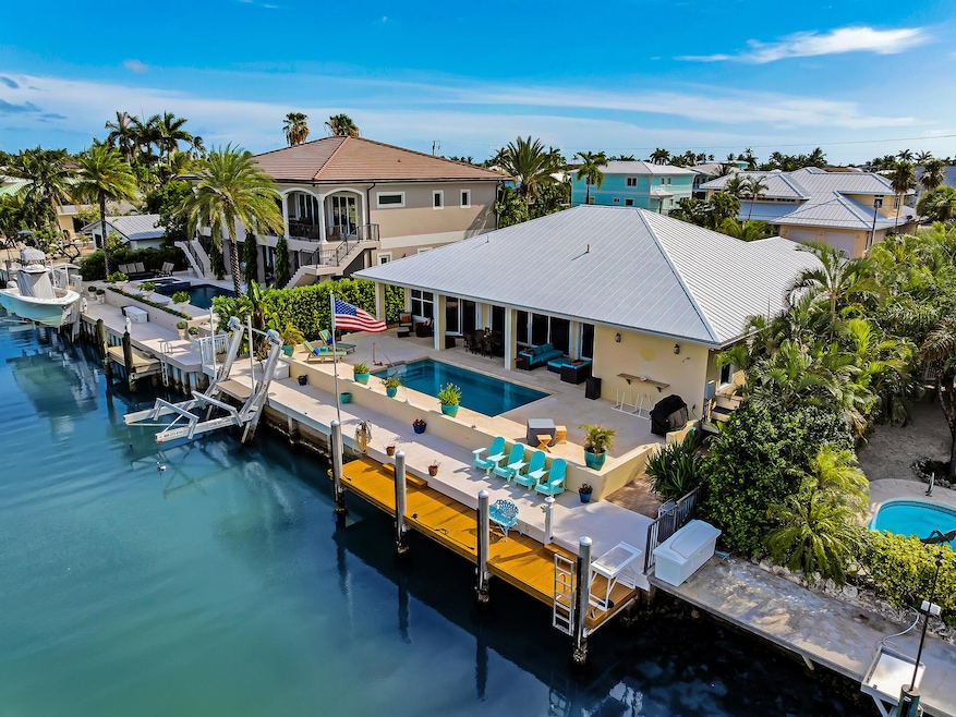
This beautifully crafted, custom-built residence by renowned builder Jeff Ryder is now available for the first time. Lovingly maintained by the original owner and never used as a rental, the home feels like new. Step into a wide open floor plan enhanced by 10-foot ceilings, elegant crown molding, 8-foot solid wood doors, and expansive wall-to-wall impact glass sliders that seamlessly blend indoor and outdoor living. The spacious covered patio is perfect for al fresco dining, game day gatherings, or simply relaxing by the pool. Anglers, divers, boating enthusiasts and blue water lovers will appreciate the open canal views. Be impressed with the 75' x 5' concrete seawall, 16,000 lb elevator boat lift, and 30' step-down dock along a crystal-clear, 100-foot-wide canal that's 5 feet deep. All just 5 minutes from both the open Atlantic Ocean and the open Gulf. Ideally located in the heart of the Florida Keys in desirable Key Colony Beach, you can walk or bike the entire 15-street city to enjoy pickleball, golf, marina, restaurants, shopping, playgrounds, post office, city hall, and the stunning waterfront Sunset Park.Great storage is found in the oversized 2-car garage with a floored attic above, plus there's plenty of room for your toys with a paved circular driveway. The property is lushly landscaped for both beauty and privacy. Fly directly into paradise via Marathon Executive Airport, Key West International, or Miami International airport and welcome to your tropical escape. Whether you're an angler, diver, snorkeler, or simply love the island lifestyle, this is the ultimate Florida Keys retreat to call home.
Home Details
Home Type
- Single Family
Est. Annual Taxes
- $6,675
Year Built
- Built in 2012 | Remodeled
Lot Details
- 8,250 Sq Ft Lot
- Home fronts a canal
- Fenced
- Property is zoned R-1A - Key Colony Single Family
Home Design
- Metal Roof
Interior Spaces
- 2,077 Sq Ft Home
- Furnished
- Crown Molding
- Cathedral Ceiling
- Ceiling Fan
- Blinds
- Storage
- Tile Flooring
- Canal Views
Kitchen
- Range
- Microwave
- Ice Maker
- Dishwasher
- Wine Cooler
- Stainless Steel Appliances
- Granite Countertops
- Disposal
Bedrooms and Bathrooms
- 3 Bedrooms
- Split Bedroom Floorplan
- Walk-In Closet
Laundry
- Laundry Room
- Dryer
- Washer
Home Security
- Monitored
- Complete Electric Power Shutters
- Impact Glass
- Fire and Smoke Detector
Parking
- 2 Car Garage
- Automatic Garage Door Opener
- Guest Parking
- Off-Street Parking
- RV or Boat Parking
Pool
- Concrete Pool
- Heated In Ground Pool
- Saltwater Pool
- Pool Deck
Outdoor Features
- Airstrip
- Seawall
- Boat Lift
- Dock made with wood
- Tennis Courts
- Balcony
- Patio
- Exterior Lighting
- Rain Gutters
Location
- Ground Level
Utilities
- Central Air
- Heating Available
- Public Hookup Available For Sewer
- Community Sewer or Septic
- Cable TV Available
Listing and Financial Details
- Homestead Exemption
- Assessor Parcel Number 00077510-000000
Community Details
Overview
- No Home Owners Association
- Key Colony Bch 2Nd Addn Subdivision
- RV Parking in Community
Recreation
- Boat Ramp
- Beach
- Tennis Courts
- Bike Trail
Map
Home Values in the Area
Average Home Value in this Area
Property History
| Date | Event | Price | Change | Sq Ft Price |
|---|---|---|---|---|
| 08/10/2025 08/10/25 | For Sale | $2,675,000 | -- | $1,288 / Sq Ft |
Source: Marathon and Lower Keys Association of REALTORS®
MLS Number: 616106
- 660 11th St
- 470 122nd St
- 11456 5th Avenue Ocean
- 11202 3rd Avenue Ocean
- 12400 Overseas Hwy Unit ID1269391P
- 10 Clara Blvd
- 7201 Gulf of Mexico Blvd Unit 201
- 7401 Gulf of Mexico Blvd Unit 4
- 10877 Overseas Hwy Unit 96
- 10877 Overseas Hwy Unit 26A
- 10877 Overseas Hwy Unit 38
- 790 100th Street Ocean
- 767 98th Street Ocean
- 1215 97th St Unit 2
- 1215 97th Street Ocean Unit 11
- 728 92nd St Ocean
- 728 92nd Street Ocean
- 1301 Grouper Dr Unit A
- 7760 Aviation Blvd
- 6973 Overseas Hwy
