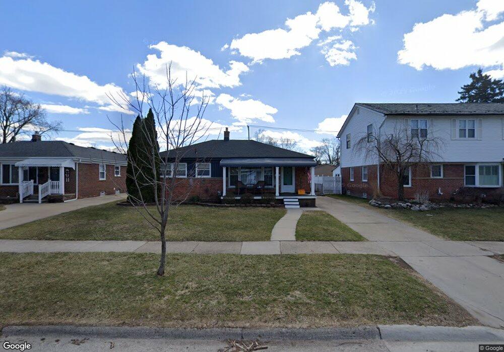
510 E Bloomfield Ave Royal Oak, MI 48073
Estimated Value: $333,148 - $425,000
3
Beds
2
Baths
1,213
Sq Ft
$308/Sq Ft
Est. Value
About This Home
This home is located at 510 E Bloomfield Ave, Royal Oak, MI 48073 and is currently estimated at $373,287, approximately $307 per square foot. 510 E Bloomfield Ave is a home located in Oakland County with nearby schools including Oak Ridge Elementary School, Royal Oak Middle School, and Royal Oak High School.
Ownership History
Date
Name
Owned For
Owner Type
Purchase Details
Closed on
Mar 24, 2015
Sold by
Prunkard Nicole and Peraino Nicole
Bought by
Peraino Nicole and Peraino Michael
Current Estimated Value
Purchase Details
Closed on
Sep 22, 2010
Sold by
Cox Linda A and Estate Of Mary T Munro
Bought by
Prunkard Nicole and Peraino Michael
Create a Home Valuation Report for This Property
The Home Valuation Report is an in-depth analysis detailing your home's value as well as a comparison with similar homes in the area
Home Values in the Area
Average Home Value in this Area
Purchase History
| Date | Buyer | Sale Price | Title Company |
|---|---|---|---|
| Peraino Nicole | -- | Abstract Title Agency | |
| Prunkard Nicole | $110,000 | Abstract Title Agency |
Source: Public Records
Tax History
| Year | Tax Paid | Tax Assessment Tax Assessment Total Assessment is a certain percentage of the fair market value that is determined by local assessors to be the total taxable value of land and additions on the property. | Land | Improvement |
|---|---|---|---|---|
| 2025 | $3,269 | $147,580 | $0 | $0 |
| 2024 | $2,488 | $135,470 | $0 | $0 |
| 2022 | $2,940 | $119,070 | $0 | $0 |
| 2020 | $2,418 | $105,020 | $0 | $0 |
| 2018 | $2,940 | $94,560 | $0 | $0 |
| 2017 | $2,826 | $94,560 | $0 | $0 |
| 2015 | -- | $84,500 | $0 | $0 |
| 2014 | -- | $77,640 | $0 | $0 |
| 2011 | -- | $65,840 | $0 | $0 |
Source: Public Records
Map
Nearby Homes
- 412 Oak Run Ct Unit 6
- 424 Oak Run Ct Unit C11
- 3011 N Alexander Ave
- 327 E La Salle Ave
- 700 Devillen Ave
- 718 Devillen Ave
- 526 Girard Ave
- 3538 Rochester Rd
- 2926 N Altadena Ave
- 140 E Lawrence Ave
- 206 E Windemere Ave
- 1019 E Windemere Ave
- 3219 N Blair Ave
- 124 E Windemere Ave
- 3015 N Vermont Ave
- 3026 N Vermont Ave
- 416 Detroit Ave
- 118 E Webster Rd
- 226 W La Salle Ave
- 3110 N Connecticut Ave
- 516 E Bloomfield Ave
- 506 E Bloomfield Ave
- 522 E Bloomfield Ave
- 523 E La Salle Ave
- 511 E La Salle Ave
- 526 E Bloomfield Ave
- 507 E La Salle Ave
- 527 E La Salle Ave
- 426 E Bloomfield Ave
- 535 E La Salle Ave
- 503 E La Salle Ave
- 511 E Bloomfield Ave
- 507 E Bloomfield Ave
- 429 E La Salle Ave
- 517 E Bloomfield Ave
- 530 E Bloomfield Ave
- 427 E Bloomfield Ave
- 523 E Bloomfield Ave
- 420 E Bloomfield Ave
- 539 E La Salle Ave
Your Personal Tour Guide
Ask me questions while you tour the home.