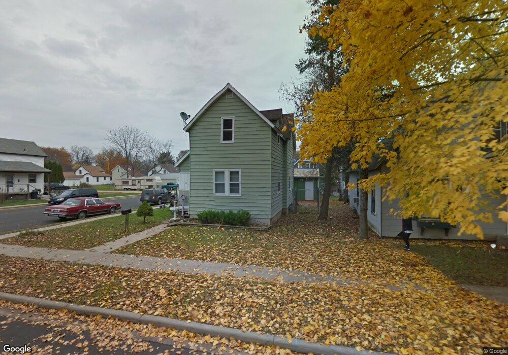
510 Elm St Mauston, WI 53948
Estimated Value: $122,000 - $195,000
3
Beds
1
Bath
1,500
Sq Ft
$100/Sq Ft
Est. Value
About This Home
This home is located at 510 Elm St, Mauston, WI 53948 and is currently estimated at $150,466, approximately $100 per square foot. 510 Elm St is a home located in Juneau County with nearby schools including West Side Elementary School, Lyndon Station Elementary School, and Grayside Elementary School.
Ownership History
Date
Name
Owned For
Owner Type
Purchase Details
Closed on
Sep 30, 2016
Sold by
Marden Kevin W
Bought by
Marden Kristopher W
Current Estimated Value
Purchase Details
Closed on
Mar 28, 2011
Sold by
Wisconsin Housing And Economic Developme
Bought by
Marden Kevin W
Purchase Details
Closed on
Aug 24, 2010
Sold by
Smith Robin D
Bought by
Wisconsin Housing And Economic Developme
Purchase Details
Closed on
Aug 29, 2005
Sold by
Federal Home Loan Mortgage Corporation
Bought by
Smith Robin D
Purchase Details
Closed on
Jun 21, 2005
Sold by
Menneke Nienneke Markh Anbettym
Bought by
Federal Home Loan Mortgage Corporation
Create a Home Valuation Report for This Property
The Home Valuation Report is an in-depth analysis detailing your home's value as well as a comparison with similar homes in the area
Home Values in the Area
Average Home Value in this Area
Purchase History
| Date | Buyer | Sale Price | Title Company |
|---|---|---|---|
| Marden Kristopher W | $55,200 | -- | |
| Marden Kevin W | $27,000 | -- | |
| Wisconsin Housing And Economic Developme | $55,200 | -- | |
| Smith Robin D | $47,900 | -- | |
| Federal Home Loan Mortgage Corporation | $61,200 | -- |
Source: Public Records
Tax History Compared to Growth
Tax History
| Year | Tax Paid | Tax Assessment Tax Assessment Total Assessment is a certain percentage of the fair market value that is determined by local assessors to be the total taxable value of land and additions on the property. | Land | Improvement |
|---|---|---|---|---|
| 2024 | $2,359 | $98,100 | $6,800 | $91,300 |
| 2023 | $2,145 | $98,100 | $6,800 | $91,300 |
| 2022 | $2,113 | $98,100 | $6,800 | $91,300 |
| 2021 | $1,854 | $62,500 | $5,700 | $56,800 |
| 2020 | $1,814 | $62,500 | $5,700 | $56,800 |
| 2019 | $1,793 | $62,500 | $5,700 | $56,800 |
| 2018 | $1,734 | $62,500 | $5,700 | $56,800 |
| 2017 | $1,720 | $62,500 | $5,700 | $56,800 |
| 2016 | $1,746 | $62,500 | $5,700 | $56,800 |
| 2015 | $1,903 | $62,500 | $5,700 | $56,800 |
| 2014 | $1,777 | $62,500 | $5,700 | $56,800 |
| 2013 | $1,855 | $62,500 | $5,700 | $56,800 |
Source: Public Records
Map
Nearby Homes
- 202 Wisconsin St
- 120 W Milwaukee St
- 234 Tremont St
- 415 West Ave
- 318 Tremont St
- L5 Buttner Ct
- 108 Hanover St
- 0 Fleet St Unit 1978417
- 12.35 AC Highway 58 Trunk
- 914 Marshall Dr
- 810 S Hickory St
- 813 S Hickory St
- Lot 47 Turner Dr
- 506 W State St
- L31 Heath Ct
- 722 E State St
- 207 Highview Ave
- 420 E Monroe St
- 0.3 acres Lincoln St
- 1.6 acres Prospect and Lincoln St