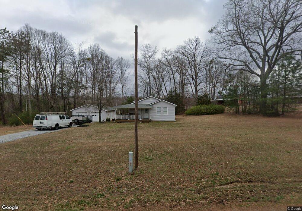
510 Grogan Rd Woodruff, SC 29388
Estimated Value: $153,000 - $359,000
3
Beds
1
Bath
920
Sq Ft
$251/Sq Ft
Est. Value
About This Home
This home is located at 510 Grogan Rd, Woodruff, SC 29388 and is currently estimated at $230,521, approximately $250 per square foot. 510 Grogan Rd is a home with nearby schools including Woodruff Primary School, Woodruff Elementary School, and Woodruff Middle School.
Ownership History
Date
Name
Owned For
Owner Type
Purchase Details
Closed on
Jan 16, 2018
Sold by
Anthony Hughlene and Crooke Timothy W
Bought by
Reber Ii Henry and Barrett Rebecca
Current Estimated Value
Home Financials for this Owner
Home Financials are based on the most recent Mortgage that was taken out on this home.
Original Mortgage
$90,800
Outstanding Balance
$76,624
Interest Rate
3.94%
Mortgage Type
New Conventional
Estimated Equity
$153,897
Purchase Details
Closed on
Jun 5, 2014
Sold by
Estate Of Michael K Crooke
Bought by
Crooke Mildred T
Create a Home Valuation Report for This Property
The Home Valuation Report is an in-depth analysis detailing your home's value as well as a comparison with similar homes in the area
Home Values in the Area
Average Home Value in this Area
Purchase History
| Date | Buyer | Sale Price | Title Company |
|---|---|---|---|
| Reber Ii Henry | $113,500 | None Available | |
| Crooke Mildred T | -- | -- |
Source: Public Records
Mortgage History
| Date | Status | Borrower | Loan Amount |
|---|---|---|---|
| Open | Reber Ii Henry | $90,800 |
Source: Public Records
Tax History Compared to Growth
Tax History
| Year | Tax Paid | Tax Assessment Tax Assessment Total Assessment is a certain percentage of the fair market value that is determined by local assessors to be the total taxable value of land and additions on the property. | Land | Improvement |
|---|---|---|---|---|
| 2025 | $422 | $2,289 | $421 | $1,868 |
| 2024 | $422 | $2,289 | $421 | $1,868 |
| 2023 | $422 | $2,289 | $421 | $1,868 |
| 2022 | $333 | $1,995 | $259 | $1,736 |
| 2021 | $337 | $1,995 | $259 | $1,736 |
| 2020 | $303 | $1,995 | $259 | $1,736 |
| 2019 | $1,186 | $1,948 | $212 | $1,736 |
| 2018 | $302 | $1,948 | $212 | $1,736 |
| 2017 | $969 | $2,620 | $298 | $2,322 |
| 2016 | $970 | $2,620 | $298 | $2,322 |
| 2015 | $2,906 | $8,286 | $5,700 | $2,586 |
| 2014 | $1,207 | $3,370 | $784 | $2,586 |
Source: Public Records
Map
Nearby Homes
- 0 Grogan Rd Unit SPN328763
- 400 Grogan Rd
- 1442 Bob Cat Ln
- 215 Pearson Rd
- 1021 Pearson Rd
- 516 Winstone Trail
- Stonehaven - Finished Basement Plan at Pinebrook
- Stonefield Plan at Pinebrook
- Stonehaven Plan at Pinebrook
- Wakefield Plan at Pinebrook
- Sutherland Plan at Pinebrook
- Kendrick Plan at Pinebrook
- Kendrick - Finished Basement Plan at Pinebrook
- Oakleigh - Finished Basement Plan at Pinebrook
- Oakleigh Plan at Pinebrook
- Stonefield - Finished Basement Plan at Pinebrook
- Wakefield - Finished Basement Plan at Pinebrook
- Sutherland - Finished Basement Plan at Pinebrook
- Arlington Plan at Pinebrook
- Arlington - Finished Basement Plan at Pinebrook
- 0 Grogan Rd Unit SPN251522
- 291 & 301 Grogan Rd
- 0 Grogan Rd Unit 1464781
- 412 Grogan Rd
- 0 Grogan Rd Unit 1461632
- 0 Grogan Rd Unit 1460703
- 00 Grogan Rd
- 0 Grogan Rd Unit 1457539
- 0 Grogan Rd Unit 1457537
- 0 Grogan Rd Unit 284198
- 442 Grogan Rd
- 0 Grogan Rd Unit 1449034
- 310 Grogan Rd
- 000 Grogan Rd
- 0 Grogan Rd
- 408 Grogan Rd
- 492 Grogan Rd
- 502 Grogan Rd
- 501 Grogan Rd
- 517 Grogan Rd