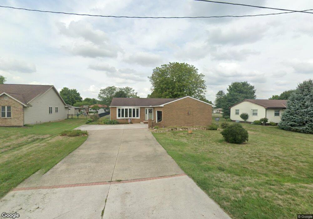
5102 Ashville Rd South Bloomfield, OH 43103
Estimated Value: $287,000 - $327,134
3
Beds
2
Baths
2,115
Sq Ft
$149/Sq Ft
Est. Value
About This Home
This home is located at 5102 Ashville Rd, South Bloomfield, OH 43103 and is currently estimated at $315,284, approximately $149 per square foot. 5102 Ashville Rd is a home located in Pickaway County.
Ownership History
Date
Name
Owned For
Owner Type
Purchase Details
Closed on
Jul 26, 1995
Sold by
Smith Robert C
Bought by
Lowry Harold M and Lowry Christina F
Current Estimated Value
Home Financials for this Owner
Home Financials are based on the most recent Mortgage that was taken out on this home.
Original Mortgage
$100,000
Interest Rate
7.59%
Mortgage Type
New Conventional
Purchase Details
Closed on
Aug 1, 1986
Create a Home Valuation Report for This Property
The Home Valuation Report is an in-depth analysis detailing your home's value as well as a comparison with similar homes in the area
Home Values in the Area
Average Home Value in this Area
Purchase History
| Date | Buyer | Sale Price | Title Company |
|---|---|---|---|
| Lowry Harold M | $114,000 | -- | |
| -- | $8,000 | -- |
Source: Public Records
Mortgage History
| Date | Status | Borrower | Loan Amount |
|---|---|---|---|
| Closed | Lowry Harold M | $100,000 |
Source: Public Records
Tax History Compared to Growth
Tax History
| Year | Tax Paid | Tax Assessment Tax Assessment Total Assessment is a certain percentage of the fair market value that is determined by local assessors to be the total taxable value of land and additions on the property. | Land | Improvement |
|---|---|---|---|---|
| 2024 | -- | $85,130 | $9,930 | $75,200 |
| 2023 | $3,265 | $85,130 | $9,930 | $75,200 |
| 2022 | $2,600 | $62,480 | $8,270 | $54,210 |
| 2021 | $2,463 | $62,480 | $8,270 | $54,210 |
| 2020 | $2,469 | $62,480 | $8,270 | $54,210 |
| 2019 | $2,130 | $53,790 | $8,270 | $45,520 |
| 2018 | $2,218 | $53,790 | $8,270 | $45,520 |
| 2017 | $2,918 | $53,790 | $8,270 | $45,520 |
| 2016 | $2,078 | $48,910 | $8,170 | $40,740 |
| 2015 | $2,079 | $48,910 | $8,170 | $40,740 |
| 2014 | $2,071 | $48,700 | $8,170 | $40,530 |
| 2013 | $2,144 | $48,720 | $8,170 | $40,550 |
Source: Public Records
Map
Nearby Homes
- 5069 Ashville Rd
- 5049 Lee Rd
- 5050 S Walnut St
- 0 U S 23
- Aspire Plan at Bloomfield Hills
- Hampton Plan at Bloomfield Hills
- Mitchell Plan at Bloomfield Hills
- Crisfield Plan at Bloomfield Hills
- Sereneda Plan at Bloomfield Hills
- Oakdale Plan at Bloomfield Hills
- 5009 Roese Ave
- 30 Bazler Ln
- The Daffodil Plan at Riverbend at Scioto Landing
- The Daisy Plan at Riverbend at Scioto Landing
- The Avalon Plan at Riverbend at Scioto Landing
- The Aster Plan at Riverbend at Scioto Landing
- 51 Henderson Ln
- 92 Richard Ave
- 94 Richard Ave
- 14337 Us Highway 23
- 5100 Ashville Rd
- 5098 Ashville Rd
- 5064 Nelson Dr
- 5070 Scioto Dr
- 5079 Ashville Rd
- 5018 Ashville Rd
- 5067 Nelson Dr
- 5088 Ashville Rd
- 5077 Ashville Rd
- 5068 Scioto Dr
- 5062 Nelson Dr
- 5065 Nelson Dr
- 5075 Ashville Rd
- 5061 Nelson Dr
- 5061 Lee Rd
- 5062 Lee Rd
- 5073 Ashville Rd
- 5058 Nelson Dr
- 5059 Lee Rd
- 5065 Cook Rd