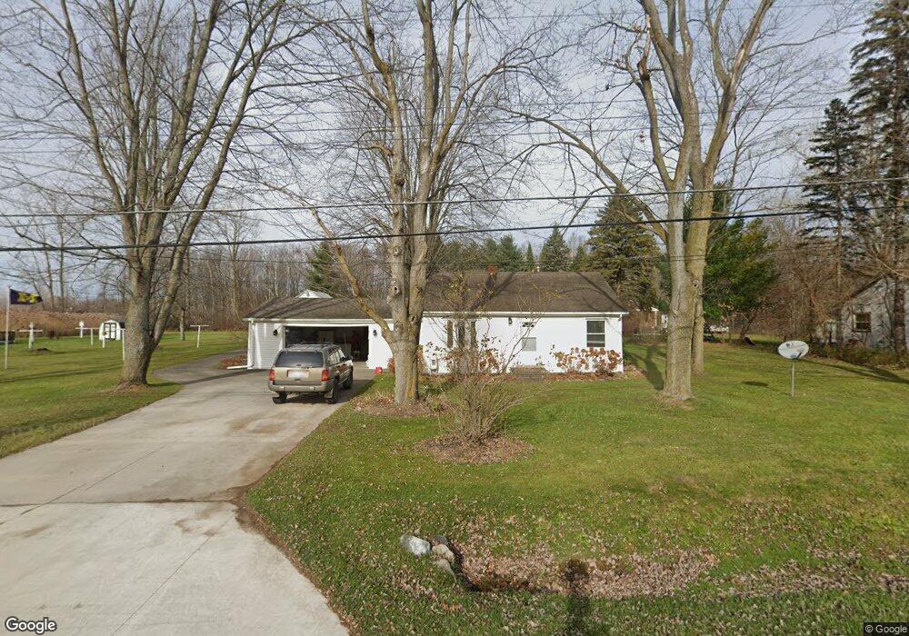
5104 Dove Rd Kimball, MI 48074
Estimated Value: $217,000 - $245,000
2
Beds
1
Bath
1,568
Sq Ft
$147/Sq Ft
Est. Value
About This Home
This home is located at 5104 Dove Rd, Kimball, MI 48074 and is currently estimated at $229,895, approximately $146 per square foot. 5104 Dove Rd is a home located in St. Clair County with nearby schools including Kimball Elementary School, Central Middle School, and Port Huron High School.
Ownership History
Date
Name
Owned For
Owner Type
Purchase Details
Closed on
Feb 11, 2009
Sold by
Zauner Robert Alan and Zauner Michelle Lee
Bought by
Farr Pamela and Farr Pamela M
Current Estimated Value
Home Financials for this Owner
Home Financials are based on the most recent Mortgage that was taken out on this home.
Original Mortgage
$86,700
Interest Rate
5.2%
Mortgage Type
New Conventional
Create a Home Valuation Report for This Property
The Home Valuation Report is an in-depth analysis detailing your home's value as well as a comparison with similar homes in the area
Home Values in the Area
Average Home Value in this Area
Purchase History
| Date | Buyer | Sale Price | Title Company |
|---|---|---|---|
| Farr Pamela | $85,000 | Huron Title Company |
Source: Public Records
Mortgage History
| Date | Status | Borrower | Loan Amount |
|---|---|---|---|
| Previous Owner | Farr Pamela | $86,700 |
Source: Public Records
Tax History
| Year | Tax Paid | Tax Assessment Tax Assessment Total Assessment is a certain percentage of the fair market value that is determined by local assessors to be the total taxable value of land and additions on the property. | Land | Improvement |
|---|---|---|---|---|
| 2025 | $922 | $99,400 | $0 | $0 |
| 2024 | $895 | $95,200 | $0 | $0 |
| 2023 | $820 | $91,800 | $0 | $0 |
| 2022 | $1,468 | $84,400 | $0 | $0 |
| 2020 | $1,351 | $78,700 | $78,700 | $0 |
| 2019 | $1,313 | $63,600 | $0 | $0 |
| 2018 | $1,286 | $60,400 | $0 | $0 |
| 2017 | $1,273 | $56,900 | $0 | $0 |
| 2016 | $667 | $56,900 | $0 | $0 |
| 2015 | -- | $54,600 | $54,600 | $0 |
| 2014 | -- | $46,900 | $46,900 | $0 |
| 2013 | -- | $58,500 | $0 | $0 |
Source: Public Records
Map
Nearby Homes
- 1604 Allen Rd
- V/L Allen
- 1786 Omar Rd
- 5117 Ravenswood Rd
- 00 Range Rd
- 1405 Range Rd
- 0 Ravenswood Rd Unit 20251017048
- 0000 Ravenswood Rd
- 1948 Meadowlark Ln
- 1906 Morningstar Ave
- 00 Howard Rd
- 0 Allen Rd Unit 20250008597
- 0 Allen Rd Unit 20250008612
- 0000 Range Rd
- 265 Westbrook Ct
- 183 Nevada Ave
- 2007 Edward Ln E
- 656 Wadhams Rd
- 174 Meadow Ln
- 153 Meadow Ln
Your Personal Tour Guide
Ask me questions while you tour the home.