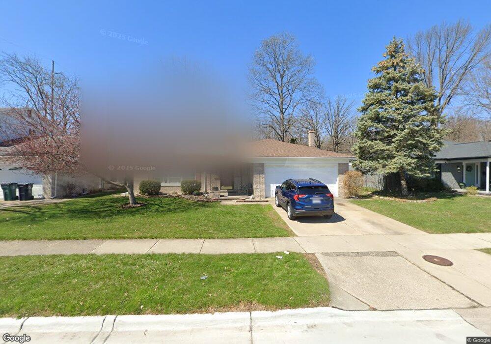
5109 Thorncroft Ct Royal Oak, MI 48073
Estimated Value: $448,000 - $513,000
4
Beds
3
Baths
1,989
Sq Ft
$236/Sq Ft
Est. Value
About This Home
This home is located at 5109 Thorncroft Ct, Royal Oak, MI 48073 and is currently estimated at $470,246, approximately $236 per square foot. 5109 Thorncroft Ct is a home located in Oakland County with nearby schools including Alfred E. Upton Elementary School, Royal Oak Middle School, and Royal Oak High School.
Ownership History
Date
Name
Owned For
Owner Type
Purchase Details
Closed on
Nov 10, 2004
Sold by
Norwood Vicki J
Bought by
Davis Glen P and Davis Katherine M
Current Estimated Value
Home Financials for this Owner
Home Financials are based on the most recent Mortgage that was taken out on this home.
Original Mortgage
$212,000
Interest Rate
5.82%
Mortgage Type
Purchase Money Mortgage
Purchase Details
Closed on
Jul 23, 2003
Sold by
Ruff Richard T and Ruff Harriet O
Bought by
Norwood Vicki J
Create a Home Valuation Report for This Property
The Home Valuation Report is an in-depth analysis detailing your home's value as well as a comparison with similar homes in the area
Home Values in the Area
Average Home Value in this Area
Purchase History
| Date | Buyer | Sale Price | Title Company |
|---|---|---|---|
| Davis Glen P | $265,000 | Title Company Michigan Inc | |
| Norwood Vicki J | $252,500 | Metropolitan Title Company |
Source: Public Records
Mortgage History
| Date | Status | Borrower | Loan Amount |
|---|---|---|---|
| Previous Owner | Davis Glen P | $212,000 |
Source: Public Records
Tax History Compared to Growth
Tax History
| Year | Tax Paid | Tax Assessment Tax Assessment Total Assessment is a certain percentage of the fair market value that is determined by local assessors to be the total taxable value of land and additions on the property. | Land | Improvement |
|---|---|---|---|---|
| 2024 | $3,387 | $185,660 | $0 | $0 |
| 2022 | $4,002 | $167,720 | $0 | $0 |
| 2020 | $3,291 | $148,870 | $0 | $0 |
| 2018 | $4,002 | $117,180 | $0 | $0 |
| 2017 | $3,847 | $117,180 | $0 | $0 |
| 2015 | -- | $113,840 | $0 | $0 |
| 2014 | -- | $101,770 | $0 | $0 |
| 2011 | -- | $90,280 | $0 | $0 |
Source: Public Records
Map
Nearby Homes
- 2134 Wickham St
- 1936 Torquay Ave Unit 205
- 1823 Torquay Ave
- 2425 Torquay Ave Unit 101A
- 2440 Parmenter Blvd Unit 112
- 2420 Parmenter Blvd Unit 101
- 4921 N Crooks Rd Unit N-10
- 496 Langley Blvd
- 4820 Briarwood Ave Unit 4
- 4859 Mansfield Ave Unit H5
- 4830 Briarwood Ave Unit 2
- 4921 Crooks Rd Unit M-10
- 4909 Crooks Rd Unit C7
- 4909 Crooks Rd Unit E8
- 4909 Crooks Rd Unit 4
- 4840 Briarwood Ave Unit 8
- 2356 W 14 Mile Rd Unit 1
- 851 N Webik Ave
- 4625 Leafdale Ave
- 4422 Rosewold Ave
- 5103 Thorncroft Ct
- 5115 Thorncroft Ct
- 5110 Elmhurst Ave
- 5104 Elmhurst Ave
- 5121 Thorncroft Ct
- 5116 Elmhurst Ave
- 5097 Thorncroft Ave
- 5108 Thorncroft Ct
- 5124 Elmhurst Ave
- 5124 Elmhurst Ave
- 5102 Thorncroft Ct
- 5114 Thorncroft Ct
- 5127 Thorncroft Ct
- 5094 Elmhurst Ave
- 5120 Thorncroft Ct
- 5093 Thorncroft Ave
- 5130 Elmhurst Ave
- 5098 Thorncroft Ave
- 5090 Elmhurst Ave Unit Bldg-Unit
- 5090 Elmhurst Ave