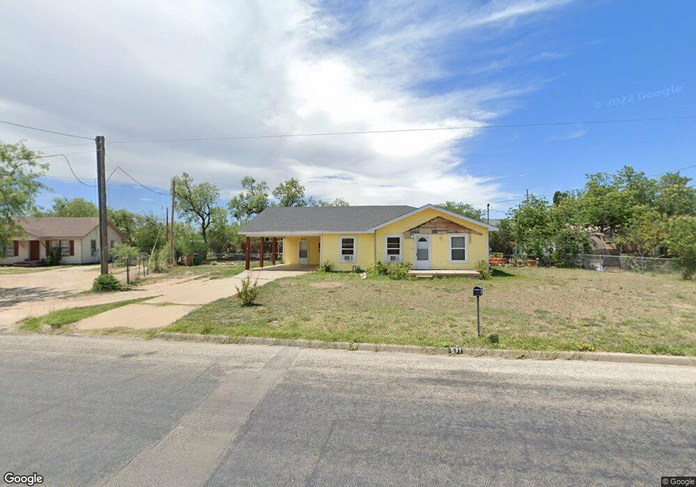
511 Baker St San Angelo, TX 76903
Fort Concho NeighborhoodEstimated Value: $118,000 - $130,000
Studio
--
Bath
1,004
Sq Ft
$125/Sq Ft
Est. Value
About This Home
This home is located at 511 Baker St, San Angelo, TX 76903 and is currently estimated at $125,546, approximately $125 per square foot. 511 Baker St is a home located in Tom Green County with nearby schools including Ft. Concho Elementary School, Glenn Middle School, and Central High School.
Ownership History
Date
Name
Owned For
Owner Type
Purchase Details
Closed on
Feb 19, 2004
Sold by
Harrison Wesley W - Owner
Bought by
Valadez Juan Diego and Alesia Guevara
Current Estimated Value
Purchase Details
Closed on
Nov 22, 1994
Sold by
Harrison Wesley W
Bought by
Valadez Juan Diego and Alesia Guevara
Purchase Details
Closed on
Jan 19, 1989
Sold by
Carmichael H C - Deceased
Bought by
Valadez Juan Diego and Alesia Guevara
Create a Home Valuation Report for This Property
The Home Valuation Report is an in-depth analysis detailing your home's value as well as a comparison with similar homes in the area
Home Values in the Area
Average Home Value in this Area
Purchase History
| Date | Buyer | Sale Price | Title Company |
|---|---|---|---|
| Valadez Juan Diego | -- | -- | |
| Valadez Juan Diego | -- | -- | |
| Valadez Juan Diego | -- | -- |
Source: Public Records
Tax History
| Year | Tax Paid | Tax Assessment Tax Assessment Total Assessment is a certain percentage of the fair market value that is determined by local assessors to be the total taxable value of land and additions on the property. | Land | Improvement |
|---|---|---|---|---|
| 2025 | $759 | $113,170 | $33,180 | $79,990 |
| 2024 | $661 | $92,910 | $33,180 | $59,730 |
| 2023 | $601 | $101,720 | $39,940 | $61,780 |
| 2022 | $1,286 | $68,970 | $12,720 | $56,250 |
| 2021 | $1,279 | $52,770 | $0 | $0 |
| 2020 | $1,297 | $52,770 | $9,500 | $43,270 |
| 2019 | $1,336 | $52,770 | $9,500 | $43,270 |
| 2018 | $1,344 | $53,320 | $9,500 | $43,820 |
| 2017 | $1,328 | $52,940 | $9,500 | $43,440 |
| 2016 | $1,238 | $52,940 | $9,500 | $43,440 |
| 2015 | $707 | $55,650 | $9,500 | $46,150 |
| 2014 | $749 | $49,820 | $9,500 | $40,320 |
| 2013 | $664 | $40,100 | $0 | $0 |
Source: Public Records
Map
Nearby Homes
- 513 Powell St
- 625,621 Powell St
- 626 Parsons St
- 601 Rio Concho Dr Unit 18-19
- 611 E Avenue D
- 0 Allen St Unit 6
- 210 S Baze St Unit 3
- 206 S Baze St Unit 2
- 211 S Buchanan St
- 213 S Buchanan St
- 46 E Washington Dr
- 415 E Harris Ave
- 1516 E Harris Ave
- 210 W Avenue B
- 1502 Mayse St
- 911 Todd Ln
- 1518 Mayse St
- 1312 S Chadbourne St
- 1417 Coke St
- 616 Koberlin St
Your Personal Tour Guide
Ask me questions while you tour the home.