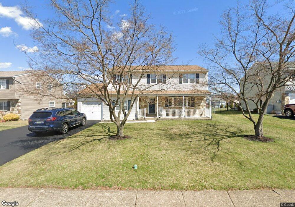
511 Fisher Ln Warminster, PA 18974
Estimated Value: $540,000 - $558,000
4
Beds
3
Baths
2,552
Sq Ft
$215/Sq Ft
Est. Value
About This Home
This home is located at 511 Fisher Ln, Warminster, PA 18974 and is currently estimated at $547,877, approximately $214 per square foot. 511 Fisher Ln is a home located in Bucks County with nearby schools including McDonald Elementary School, Log College Middle School, and William Tennent High School.
Ownership History
Date
Name
Owned For
Owner Type
Purchase Details
Closed on
Aug 15, 2001
Sold by
Dolan Daniel M and Dolan Annemarie E
Bought by
Zysk John M and Zysk Colleen M
Current Estimated Value
Home Financials for this Owner
Home Financials are based on the most recent Mortgage that was taken out on this home.
Original Mortgage
$172,000
Outstanding Balance
$67,385
Interest Rate
7.21%
Estimated Equity
$480,492
Purchase Details
Closed on
Jul 2, 1992
Bought by
Dolan Daniel M and Dolan Annemarie E
Create a Home Valuation Report for This Property
The Home Valuation Report is an in-depth analysis detailing your home's value as well as a comparison with similar homes in the area
Home Values in the Area
Average Home Value in this Area
Purchase History
| Date | Buyer | Sale Price | Title Company |
|---|---|---|---|
| Zysk John M | $215,000 | -- | |
| Dolan Daniel M | $150,000 | -- |
Source: Public Records
Mortgage History
| Date | Status | Borrower | Loan Amount |
|---|---|---|---|
| Open | Zysk John M | $172,000 | |
| Closed | Zysk John M | $32,250 |
Source: Public Records
Tax History Compared to Growth
Tax History
| Year | Tax Paid | Tax Assessment Tax Assessment Total Assessment is a certain percentage of the fair market value that is determined by local assessors to be the total taxable value of land and additions on the property. | Land | Improvement |
|---|---|---|---|---|
| 2025 | $6,442 | $30,520 | $5,080 | $25,440 |
| 2024 | $6,442 | $30,520 | $5,080 | $25,440 |
| 2023 | $6,243 | $30,520 | $5,080 | $25,440 |
| 2022 | $6,110 | $30,520 | $5,080 | $25,440 |
| 2021 | $5,968 | $30,520 | $5,080 | $25,440 |
| 2020 | $5,884 | $30,520 | $5,080 | $25,440 |
| 2019 | $5,571 | $30,520 | $5,080 | $25,440 |
| 2018 | $5,438 | $30,520 | $5,080 | $25,440 |
| 2017 | $5,279 | $30,520 | $5,080 | $25,440 |
| 2016 | $5,279 | $30,520 | $5,080 | $25,440 |
| 2015 | $5,143 | $30,520 | $5,080 | $25,440 |
| 2014 | $5,143 | $30,520 | $5,080 | $25,440 |
Source: Public Records
Map
Nearby Homes
- 524 Penrose Ln
- 713 Mason Dr
- 632 Longfellow Ct
- Lot 15 Kennedy Way
- 0 York Rd
- 995 Howard Rd
- 422 Brandywine Ct Unit YV422
- 408 Brandywine Ct Unit YV408
- 675 Cheryl Dr
- 446 Maple St
- 905 Holden Ct
- 667 Arbor Ln
- 724 Cypress Rd
- 220 Nemoral St
- 1240 June Rd
- 200 Maple St
- 942 Stein Ct
- 451 Twin Streams Dr
- 109 Wilson Ave
- 1256 Dahlia Rd