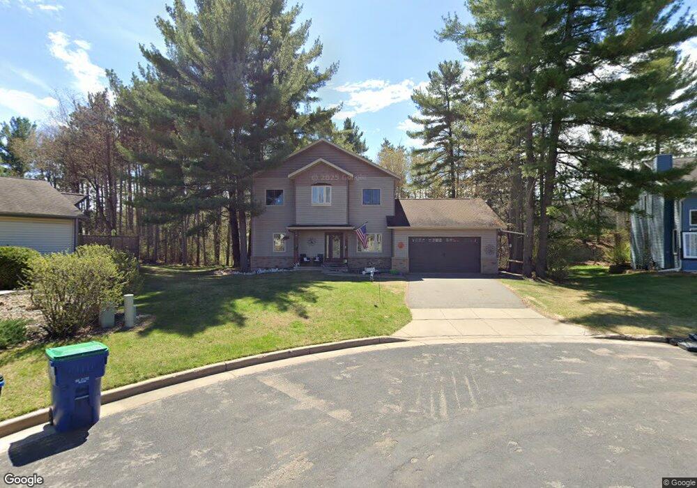
511 Roger Dr Wausau, WI 54401
Estimated Value: $346,450 - $417,000
3
Beds
2
Baths
1,981
Sq Ft
$190/Sq Ft
Est. Value
About This Home
This home is located at 511 Roger Dr, Wausau, WI 54401 and is currently estimated at $376,863, approximately $190 per square foot. 511 Roger Dr is a home located in Marathon County with nearby schools including Stettin Elementary School, John Muir Middle School, and West High School.
Ownership History
Date
Name
Owned For
Owner Type
Purchase Details
Closed on
Dec 28, 2010
Sold by
Millennium Construction Of Wisconsin Inc
Bought by
Fortenberry Johnny Jay and Fortenberry Sibylle
Current Estimated Value
Home Financials for this Owner
Home Financials are based on the most recent Mortgage that was taken out on this home.
Original Mortgage
$164,025
Outstanding Balance
$110,319
Interest Rate
4.5%
Mortgage Type
VA
Estimated Equity
$266,544
Purchase Details
Closed on
May 24, 2006
Sold by
Kings Enterprises Of Wausau Inc
Bought by
Millennium Construction Of Wisconsin Inc
Home Financials for this Owner
Home Financials are based on the most recent Mortgage that was taken out on this home.
Original Mortgage
$159,600
Interest Rate
6.56%
Mortgage Type
Construction
Purchase Details
Closed on
Dec 19, 2005
Sold by
Hicks Kevin J and Friedrich Tammy S
Bought by
King S Enterprises Of Wausau Inc
Create a Home Valuation Report for This Property
The Home Valuation Report is an in-depth analysis detailing your home's value as well as a comparison with similar homes in the area
Home Values in the Area
Average Home Value in this Area
Purchase History
| Date | Buyer | Sale Price | Title Company |
|---|---|---|---|
| Fortenberry Johnny Jay | $180,000 | None Available | |
| Millennium Construction Of Wisconsin Inc | $35,000 | None Available | |
| King S Enterprises Of Wausau Inc | $28,000 | None Available |
Source: Public Records
Mortgage History
| Date | Status | Borrower | Loan Amount |
|---|---|---|---|
| Open | Fortenberry Johnny Jay | $164,025 | |
| Previous Owner | Millennium Construction Of Wisconsin Inc | $159,600 |
Source: Public Records
Tax History Compared to Growth
Tax History
| Year | Tax Paid | Tax Assessment Tax Assessment Total Assessment is a certain percentage of the fair market value that is determined by local assessors to be the total taxable value of land and additions on the property. | Land | Improvement |
|---|---|---|---|---|
| 2024 | $4,340 | $340,200 | $35,000 | $305,200 |
| 2023 | $5,534 | $230,500 | $38,800 | $191,700 |
| 2022 | $5,567 | $230,500 | $38,800 | $191,700 |
| 2021 | $5,367 | $230,500 | $38,800 | $191,700 |
| 2020 | $5,540 | $230,500 | $38,800 | $191,700 |
| 2019 | $5,391 | $210,800 | $28,400 | $182,400 |
| 2018 | $5,525 | $210,800 | $28,400 | $182,400 |
| 2017 | $5,199 | $210,800 | $28,400 | $182,400 |
| 2016 | $5,045 | $210,800 | $28,400 | $182,400 |
| 2015 | $5,316 | $210,800 | $28,400 | $182,400 |
| 2014 | $4,405 | $183,900 | $39,700 | $144,200 |
Source: Public Records
Map
Nearby Homes
- 210 Bluestone Dr
- 303 Rimrock Rd
- 5713 Birchwood Dr
- 6007 Birchwood Dr
- 212 Windtree Dr
- 210 S 45th Ave
- 4615 Rib River Trail
- 6603 Conner Davis Dr
- 6607 Morgan Creek Dr
- 206 N 44th Ave
- 6011 Stettin Dr
- 116 S 68th Ave
- 310 Lisbeth Rd
- 10.80 Acres N 72nd Ave
- 3401 Christian Ave
- 2812 Hubbill Ave
- 227815 Sharptail Rd
- 145683 Flint Creek Cir
- 231747 Twin Fawn Trail
- 231781 Twin Fawn Trail
- 517 Roger Dr
- 505 Roger Dr
- 506 S 54th Ave
- 506 Roger Dr
- 5451 Lombardy Dr
- 5501 Lombardy Dr
- 5423 Lombardy Dr
- 511 S 54th Ave
- 5513 Lombardy Dr
- 5450 Lombardy Dr
- 507 S 54th Ave
- 525 S 56th Ave
- 5320 Lombardy Dr
- 5512 Lombardy Dr
- 505 S 56th Ave
- 5301 Lombardy Dr
- 5312 Lombardy Dr
- 512 S 52nd Ave
- 5415 Roger Dr
- 327 S 56th Ave