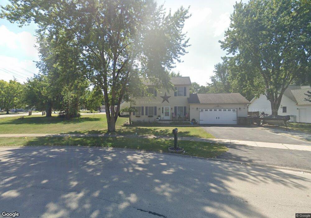
511 W Anndon St Braidwood, IL 60408
Estimated Value: $281,044 - $307,000
3
Beds
3
Baths
1,800
Sq Ft
$163/Sq Ft
Est. Value
About This Home
This home is located at 511 W Anndon St, Braidwood, IL 60408 and is currently estimated at $292,761, approximately $162 per square foot. 511 W Anndon St is a home located in Will County with nearby schools including Reed-Custer Intermediate School, Reed-Custer Middle School, and Reed-Custer High School.
Ownership History
Date
Name
Owned For
Owner Type
Purchase Details
Closed on
May 13, 2011
Sold by
Wells Fargo Bank N A
Bought by
Uthe Joshua
Current Estimated Value
Home Financials for this Owner
Home Financials are based on the most recent Mortgage that was taken out on this home.
Original Mortgage
$116,640
Interest Rate
5.25%
Mortgage Type
FHA
Purchase Details
Closed on
Mar 16, 2011
Sold by
Donnelly David and Donnelly Sandra
Bought by
Wells Fargo Bank N A
Home Financials for this Owner
Home Financials are based on the most recent Mortgage that was taken out on this home.
Original Mortgage
$116,640
Interest Rate
5.25%
Mortgage Type
FHA
Purchase Details
Closed on
Oct 27, 2010
Sold by
Donnelly David
Bought by
Wells Fargo Bank N A
Purchase Details
Closed on
Jun 22, 2005
Sold by
Grundy Bank
Bought by
Donnelly David A
Home Financials for this Owner
Home Financials are based on the most recent Mortgage that was taken out on this home.
Original Mortgage
$160,200
Interest Rate
8.35%
Mortgage Type
Fannie Mae Freddie Mac
Create a Home Valuation Report for This Property
The Home Valuation Report is an in-depth analysis detailing your home's value as well as a comparison with similar homes in the area
Home Values in the Area
Average Home Value in this Area
Purchase History
| Date | Buyer | Sale Price | Title Company |
|---|---|---|---|
| Uthe Joshua | $90,000 | None Available | |
| Wells Fargo Bank N A | -- | None Available | |
| Wells Fargo Bank N A | $121,600 | None Available | |
| Donnelly David A | $178,000 | Ticor Title |
Source: Public Records
Mortgage History
| Date | Status | Borrower | Loan Amount |
|---|---|---|---|
| Previous Owner | Uthe Joshua | $116,640 | |
| Previous Owner | Donnelly David A | $160,200 |
Source: Public Records
Tax History Compared to Growth
Tax History
| Year | Tax Paid | Tax Assessment Tax Assessment Total Assessment is a certain percentage of the fair market value that is determined by local assessors to be the total taxable value of land and additions on the property. | Land | Improvement |
|---|---|---|---|---|
| 2024 | $5,225 | $86,197 | $15,883 | $70,314 |
| 2023 | $5,225 | $77,203 | $14,226 | $62,977 |
| 2022 | $4,410 | $70,057 | $12,909 | $57,148 |
| 2021 | $4,265 | $66,867 | $12,321 | $54,546 |
| 2020 | $4,039 | $63,351 | $11,673 | $51,678 |
| 2019 | $3,805 | $59,822 | $11,023 | $48,799 |
| 2018 | $3,655 | $57,246 | $10,548 | $46,698 |
| 2017 | $3,584 | $56,123 | $10,341 | $45,782 |
| 2016 | $3,488 | $54,278 | $10,001 | $44,277 |
| 2015 | $3,360 | $52,877 | $9,743 | $43,134 |
| 2014 | $3,360 | $52,877 | $9,743 | $43,134 |
| 2013 | $3,360 | $56,553 | $10,420 | $46,133 |
Source: Public Records
Map
Nearby Homes
- 430 W 7th St
- 495 W 6th St
- 605 N Division St
- 584 N Division St
- 0000 N Division St
- 642 W Bergera Rd
- 495 N Division St
- 470 N Walker St
- 466 N Walker St
- 460 N School St
- 470 N School St
- 571 N Lincoln St
- 837 Blackhawk Dr
- 340 N Walker St
- 886 Western Ave
- 999 W Cermak Rd
- 1021 W Cermak Rd
- 1034 Madison Ave
- 1018 Madison Ave
- 203 E Coal City Rd
- 543 W Anndon St
- 844 N Division St
- Lot 1 N Division St
- Lot 2 N Division St
- 575 W Anndon St
- 508 W Anndon St
- 834 N Division St
- 548 W Anndon St
- 597 W Anndon St
- 883 N Division St
- 496 W Anndon St
- 580 W Anndon St
- 814 N Division St
- 833 N Division St
- 601 W Anndon St
- 484 W Anndon St
- 942 N Division St
- 813 N Division St
- 929 N Mabel Ct
- 0 W Anndon St