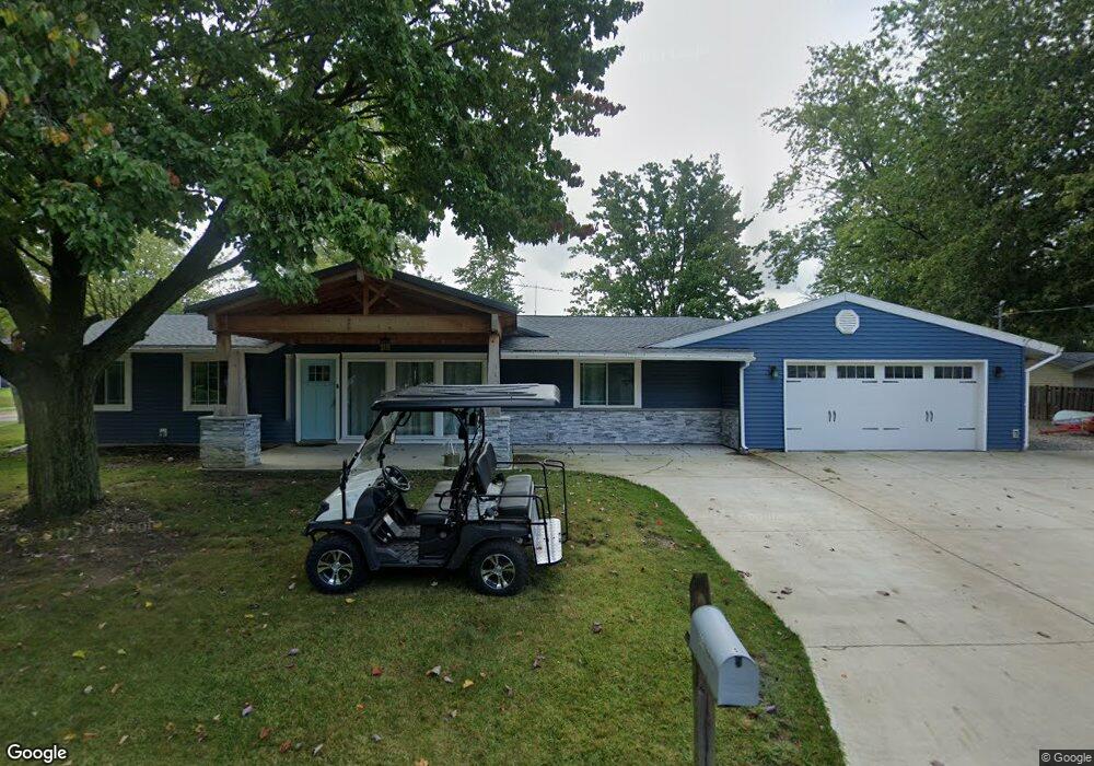
5111 Devon Dr Vermilion, OH 44089
Estimated Value: $218,000 - $249,000
3
Beds
2
Baths
1,568
Sq Ft
$150/Sq Ft
Est. Value
About This Home
This home is located at 5111 Devon Dr, Vermilion, OH 44089 and is currently estimated at $234,783, approximately $149 per square foot. 5111 Devon Dr is a home located in Erie County with nearby schools including Vermilion Elementary School, Sailorway Middle School, and Vermilion High School.
Ownership History
Date
Name
Owned For
Owner Type
Purchase Details
Closed on
Feb 3, 2017
Sold by
Burkhammer Jesse A
Bought by
Knox Ronald D and Knox Angela D
Current Estimated Value
Purchase Details
Closed on
Aug 13, 2008
Sold by
Richardson Carol Lea
Bought by
Burkhammer Jesse A
Home Financials for this Owner
Home Financials are based on the most recent Mortgage that was taken out on this home.
Original Mortgage
$119,222
Interest Rate
6.31%
Mortgage Type
FHA
Purchase Details
Closed on
Nov 24, 1998
Sold by
Nichols Harold J
Bought by
Richardson Carol L
Home Financials for this Owner
Home Financials are based on the most recent Mortgage that was taken out on this home.
Original Mortgage
$64,000
Interest Rate
6.59%
Mortgage Type
New Conventional
Create a Home Valuation Report for This Property
The Home Valuation Report is an in-depth analysis detailing your home's value as well as a comparison with similar homes in the area
Home Values in the Area
Average Home Value in this Area
Purchase History
| Date | Buyer | Sale Price | Title Company |
|---|---|---|---|
| Knox Ronald D | $50,000 | None Available | |
| Burkhammer Jesse A | $120,500 | Maravy Title Agency Llc | |
| Richardson Carol L | $80,000 | -- |
Source: Public Records
Mortgage History
| Date | Status | Borrower | Loan Amount |
|---|---|---|---|
| Previous Owner | Burkhammer Jesse A | $119,222 | |
| Previous Owner | Richardson Carol L | $64,000 |
Source: Public Records
Tax History Compared to Growth
Tax History
| Year | Tax Paid | Tax Assessment Tax Assessment Total Assessment is a certain percentage of the fair market value that is determined by local assessors to be the total taxable value of land and additions on the property. | Land | Improvement |
|---|---|---|---|---|
| 2024 | $2,467 | $55,982 | $10,997 | $44,985 |
| 2023 | $2,467 | $50,508 | $9,996 | $40,512 |
| 2022 | $2,424 | $50,508 | $9,996 | $40,512 |
| 2021 | $2,410 | $50,510 | $10,000 | $40,510 |
| 2020 | $2,092 | $42,870 | $10,000 | $32,870 |
| 2019 | $2,166 | $42,870 | $10,000 | $32,870 |
| 2018 | $2,169 | $42,870 | $10,000 | $32,870 |
| 2017 | $1,814 | $35,420 | $9,750 | $25,670 |
| 2016 | $1,757 | $35,420 | $9,750 | $25,670 |
| 2015 | $1,731 | $35,420 | $9,750 | $25,670 |
| 2014 | $1,743 | $35,420 | $9,750 | $25,670 |
| 2013 | $1,720 | $35,420 | $9,750 | $25,670 |
Source: Public Records
Map
Nearby Homes
- 1020 Sweetbriar Dr
- 5164 Langfitt St
- 880 Exchange St
- 796 Howard Dr
- 0 Liberty Ave Unit 20252085
- 5539 South St
- 1106 State St
- 1233 State St
- 0 V L 3 Gardiner Dr
- 5015 Park Dr
- 5572 South St
- 1419 Sanford St
- 1273 Hollyview Dr
- 623 Main St
- 629 Main St
- 1330 Rolling Meadows Dr
- 1391 Hollyview Dr
- 4762 Hollyview Dr
- 586 Washington St
- 4376 Tomahawk Ln
- 1042 Sanford St
- 5117 Devon Dr
- 1000 Sanford St
- 5133 Devon Dr
- 1056 Sanford St
- 1029 Sanford St
- 5116 Devon Dr
- 1010 Sweetbriar Dr
- 986 Sanford St
- 1043 Sanford St
- 1015 Sanford St
- 5149 Devon Dr
- 5132 Devon Dr
- 1030 Sweetbriar Dr
- 987 Sanford St
- 1057 Sanford St
- 1040 Sweetbriar Dr
- 5148 Devon Dr
- 5165 Devon Dr
- 5085 Langfitt St