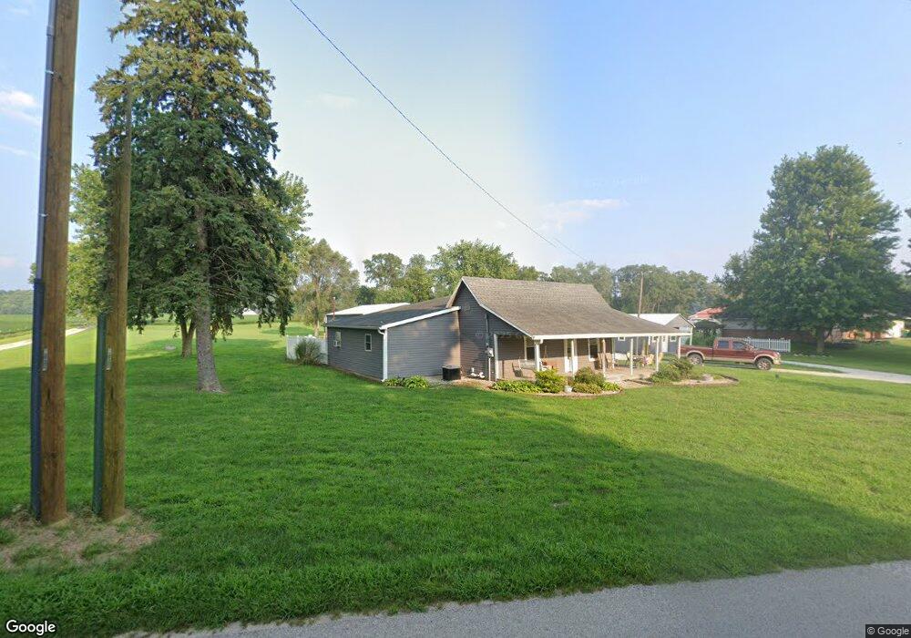
5113 N 700 W Delphi, IN 46923
Estimated Value: $219,973 - $276,000
3
Beds
2
Baths
1,510
Sq Ft
$161/Sq Ft
Est. Value
About This Home
This home is located at 5113 N 700 W, Delphi, IN 46923 and is currently estimated at $242,493, approximately $160 per square foot. 5113 N 700 W is a home located in Carroll County with nearby schools including Delphi Community Elementary School, Delphi Community Middle School, and Delphi Community High School.
Ownership History
Date
Name
Owned For
Owner Type
Purchase Details
Closed on
Sep 10, 2025
Sold by
Henderson Stephanie A and Henderson Stephanie Ann
Bought by
Jlsn Enterprises Llc
Current Estimated Value
Purchase Details
Closed on
Jul 22, 2016
Sold by
Kane Gabriel
Bought by
Henderson Stephanie A and Morris Jarrod W
Home Financials for this Owner
Home Financials are based on the most recent Mortgage that was taken out on this home.
Original Mortgage
$103,785
Interest Rate
3.87%
Mortgage Type
FHA
Purchase Details
Closed on
Dec 7, 2010
Sold by
Perdue Louis Alton and Perdue Tessa Sue
Bought by
Kane Gabriel
Home Financials for this Owner
Home Financials are based on the most recent Mortgage that was taken out on this home.
Original Mortgage
$98,445
Interest Rate
4.16%
Mortgage Type
New Conventional
Create a Home Valuation Report for This Property
The Home Valuation Report is an in-depth analysis detailing your home's value as well as a comparison with similar homes in the area
Home Values in the Area
Average Home Value in this Area
Purchase History
| Date | Buyer | Sale Price | Title Company |
|---|---|---|---|
| Jlsn Enterprises Llc | -- | None Listed On Document | |
| Henderson Stephanie A | -- | None Available | |
| Kane Gabriel | -- | None Available |
Source: Public Records
Mortgage History
| Date | Status | Borrower | Loan Amount |
|---|---|---|---|
| Previous Owner | Henderson Stephanie A | $103,785 | |
| Previous Owner | Kane Gabriel | $98,445 |
Source: Public Records
Tax History Compared to Growth
Tax History
| Year | Tax Paid | Tax Assessment Tax Assessment Total Assessment is a certain percentage of the fair market value that is determined by local assessors to be the total taxable value of land and additions on the property. | Land | Improvement |
|---|---|---|---|---|
| 2024 | $907 | $158,300 | $23,300 | $135,000 |
| 2023 | $756 | $148,900 | $23,300 | $125,600 |
| 2022 | $756 | $136,400 | $27,500 | $108,900 |
| 2021 | $787 | $134,500 | $31,700 | $102,800 |
| 2020 | $729 | $121,900 | $31,700 | $90,200 |
| 2019 | $682 | $114,300 | $31,700 | $82,600 |
| 2018 | $606 | $110,500 | $31,700 | $78,800 |
| 2017 | $526 | $104,800 | $30,000 | $74,800 |
| 2016 | $493 | $98,600 | $30,000 | $68,600 |
| 2014 | $464 | $89,300 | $27,500 | $61,800 |
Source: Public Records
Map
Nearby Homes
- 4139 N 900 W
- 610 N Wilson St
- 409 N Wilson St
- 1158 N Brewer Ave
- 317 N Market St
- 205 E Franklin St
- 116 Williston Ct
- 215 W Front St
- 112 Williston Ct
- 5122 W 700 N
- 9331 W 310 N
- 228 W Vine St
- 230 W Vine St
- 232 W Vine St
- 2801 N 930 W Unit 10
- 2075 N 925 W
- 11503 W Tecumseh Bend Rd
- 6365 Erie St
- 6374 N 260 W
- 6518 N 285 W