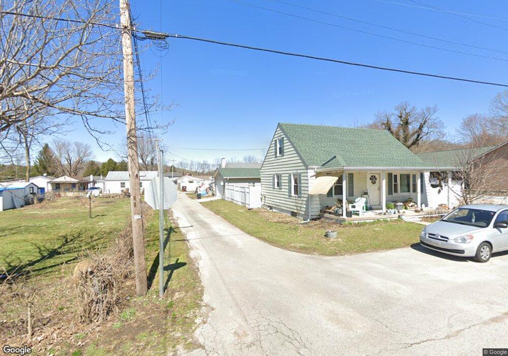
5116 Smith Aly New Trenton, IN 47035
Estimated Value: $126,065 - $151,000
2
Beds
1
Bath
1,200
Sq Ft
$114/Sq Ft
Est. Value
About This Home
This home is located at 5116 Smith Aly, New Trenton, IN 47035 and is currently estimated at $137,355, approximately $114 per square foot. 5116 Smith Aly is a home located in Franklin County with nearby schools including Franklin County High School.
Ownership History
Date
Name
Owned For
Owner Type
Purchase Details
Closed on
Aug 6, 2013
Sold by
G3erald Esterkamp
Bought by
Evelyn Esterkamp
Current Estimated Value
Purchase Details
Closed on
May 7, 2010
Sold by
Federal Home Loan Mortgage Cor Federal
Bought by
Gerald Esterkamp and Evelyn Esterkamp
Purchase Details
Closed on
Mar 29, 2010
Sold by
Fifth Third Mortgage Company Fifth Third
Bought by
Federal Home Loan Mortgage Cor Federal H
Purchase Details
Closed on
Feb 24, 2010
Sold by
Dale Maxie Franklin County She Dale Ma
Bought by
Federal Home Loan Mortgage Cor Federal
Create a Home Valuation Report for This Property
The Home Valuation Report is an in-depth analysis detailing your home's value as well as a comparison with similar homes in the area
Home Values in the Area
Average Home Value in this Area
Purchase History
| Date | Buyer | Sale Price | Title Company |
|---|---|---|---|
| Evelyn Esterkamp | -- | -- | |
| Gerald Esterkamp | $25,500 | Doyle Legal Corporation Pc | |
| Federal Home Loan Mortgage Cor Federal H | -- | Doyle Legal Corporation | |
| Federal Home Loan Mortgage Cor Federal | $37,000 | Doyle Legal Corporation Pc |
Source: Public Records
Tax History Compared to Growth
Tax History
| Year | Tax Paid | Tax Assessment Tax Assessment Total Assessment is a certain percentage of the fair market value that is determined by local assessors to be the total taxable value of land and additions on the property. | Land | Improvement |
|---|---|---|---|---|
| 2024 | $195 | $56,600 | $5,600 | $51,000 |
| 2023 | $338 | $88,200 | $4,900 | $83,300 |
| 2022 | $327 | $80,900 | $4,900 | $76,000 |
| 2021 | $283 | $75,100 | $4,900 | $70,200 |
| 2020 | $257 | $73,600 | $4,700 | $68,900 |
| 2019 | $236 | $69,500 | $4,700 | $64,800 |
| 2018 | $222 | $67,500 | $4,700 | $62,800 |
| 2017 | $210 | $61,400 | $4,700 | $56,700 |
| 2016 | $201 | $59,900 | $4,700 | $55,200 |
| 2014 | $196 | $62,800 | $4,700 | $58,100 |
| 2013 | $196 | $64,200 | $4,700 | $59,500 |
Source: Public Records
Map
Nearby Homes
- 1023 Pucksinwah Point Dr
- 6071 Saint Peters Rd
- 0000 Barber Rd
- 4175 Whitetail Dr
- 27893 Pamela Ln
- 20 Moore Dr
- 4865 Gaynor Ridge Rd
- 26175 Eagles Nest Dr
- 1068 Oak Haven Ln
- 28429 Trojan Rd
- 4014 S State Line Rd
- 0 State Rd Unit MBR22016263
- 2699 Greystone Dr
- 0 Bay Rd Unit 1860220
- 1 Bay Rd
- 11529 Deer Trace Ln
- 25656 Hearthstone Dr
- 7768 Lorraine Dr
- 4105 Schoenling Rd
- 23 Harrison Brookville Rd
- 5115 Broadway St
- 4084 Us Highway 52
- 4080 U S 52
- 5116 North St
- 5112 North St
- 5120 North St
- 0 Mt Pleasant Rd Unit 602446
- 5114 Broadway St
- 5114 Broadway St
- 4083 West St
- 4083 Us Highway 52
- 1 Depot St
- 4081 Us Highway 52
- 4083 U S 52
- 4079 Us Highway 52
- 4085 N 4085 North N
- 5117 North St
- 4105 Us Highway 52
- 5118 Broadway St
- 4072 Us Highway 52