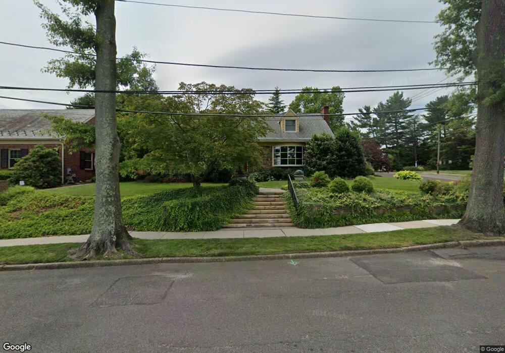
512 Devon Rd Haddonfield, NJ 08033
Estimated Value: $625,000 - $892,000
4
Beds
2
Baths
1,594
Sq Ft
$446/Sq Ft
Est. Value
About This Home
This home is located at 512 Devon Rd, Haddonfield, NJ 08033 and is currently estimated at $711,386, approximately $446 per square foot. 512 Devon Rd is a home located in Camden County with nearby schools including Avon Elementary School and Woodland Elementary School.
Ownership History
Date
Name
Owned For
Owner Type
Purchase Details
Closed on
Oct 20, 2023
Sold by
Dougherty Brian J
Bought by
Gilmartin Jaimee
Current Estimated Value
Purchase Details
Closed on
Sep 3, 2021
Sold by
Dougherty Brian J
Bought by
Dougherty Brian J
Purchase Details
Closed on
Mar 15, 2010
Sold by
Morris John J and Morris Patricia L
Bought by
Dougherty Brian J and Dougherty Pamela J
Purchase Details
Closed on
May 11, 2001
Sold by
Peterson Robert A
Bought by
Morris John J and Morris Patricia L
Home Financials for this Owner
Home Financials are based on the most recent Mortgage that was taken out on this home.
Original Mortgage
$120,000
Interest Rate
7.03%
Create a Home Valuation Report for This Property
The Home Valuation Report is an in-depth analysis detailing your home's value as well as a comparison with similar homes in the area
Home Values in the Area
Average Home Value in this Area
Purchase History
| Date | Buyer | Sale Price | Title Company |
|---|---|---|---|
| Gilmartin Jaimee | -- | None Listed On Document | |
| Dougherty Brian J | -- | Brown Marlanne Rebel | |
| Dougherty Brian J | $400,000 | -- | |
| Morris John J | $275,000 | -- |
Source: Public Records
Mortgage History
| Date | Status | Borrower | Loan Amount |
|---|---|---|---|
| Previous Owner | Morris John J | $120,000 |
Source: Public Records
Tax History
| Year | Tax Paid | Tax Assessment Tax Assessment Total Assessment is a certain percentage of the fair market value that is determined by local assessors to be the total taxable value of land and additions on the property. | Land | Improvement |
|---|---|---|---|---|
| 2025 | $15,451 | $322,700 | $129,700 | $193,000 |
| 2024 | $14,918 | $322,700 | $129,700 | $193,000 |
| 2023 | $14,918 | $322,700 | $129,700 | $193,000 |
| 2022 | $14,599 | $322,700 | $129,700 | $193,000 |
| 2021 | $14,438 | $322,700 | $129,700 | $193,000 |
| 2020 | $14,199 | $322,700 | $129,700 | $193,000 |
| 2019 | $14,137 | $322,700 | $129,700 | $193,000 |
| 2018 | $13,863 | $322,700 | $129,700 | $193,000 |
| 2017 | $13,518 | $322,700 | $129,700 | $193,000 |
| 2016 | $13,245 | $353,100 | $177,600 | $175,500 |
| 2015 | $12,810 | $353,100 | $177,600 | $175,500 |
| 2014 | $12,270 | $353,100 | $177,600 | $175,500 |
Source: Public Records
Map
Nearby Homes
- 425 Peltoma Rd
- 396 Tavistock Blvd
- 1001 Wayne Rd
- 139 Treaty Elm Ln
- 104 Treaty Elm Ln
- 342 Tavistock Blvd
- 95 Lane of Acres
- 370 Station Ave
- 413 Company St
- 51 S Hinchman Ave
- 0 Bell Ave
- 127 W Cottage Ave
- 125 W Cottage Ave
- 425 White Horse Pike
- 320 Company St
- 302 3rd Ave
- 121 Reillywood Ave
- 366 Independence Blvd
- 449 Loucroft Rd
- 414 Tavistock
- 508 Devon Rd
- 342 Hutchinson Ave
- 506 Devon Rd
- 340 Hutchinson Ave
- 345 Hutchinson Ave
- 517 Devon Rd
- 341 Hutchinson Ave
- 347 Peltoma Rd
- 507 Devon Rd
- 500 Devon Rd
- 328 Hutchinson Ave
- 427 Peltoma Rd
- 339 Hutchinson Ave
- 349 Hutchinson Ave
- 355 Hutchinson Ave
- 412 Hutchinson Ave
- 337 Hutchinson Ave
- 425A Peltoma Rd
- 950 Devon Rd
- 505 Tavistock Blvd
Your Personal Tour Guide
Ask me questions while you tour the home.