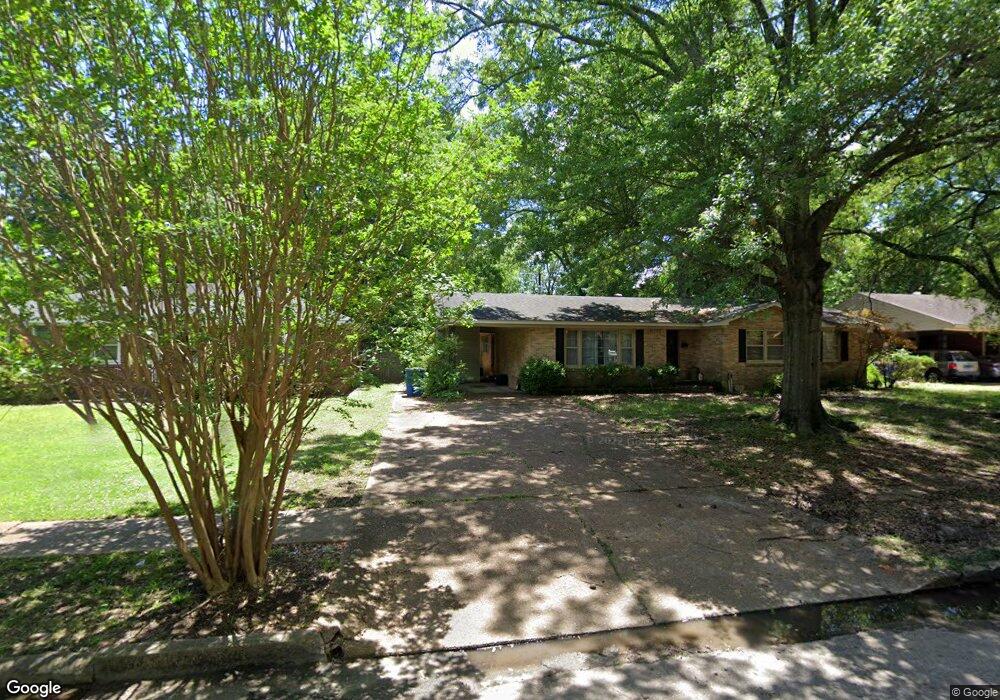
512 Gibson Ave West Memphis, AR 72301
Estimated Value: $173,023 - $208,000
3
Beds
2
Baths
1,812
Sq Ft
$102/Sq Ft
Est. Value
About This Home
This home is located at 512 Gibson Ave, West Memphis, AR 72301 and is currently estimated at $185,006, approximately $102 per square foot. 512 Gibson Ave is a home located in Crittenden County with nearby schools including Bragg Elementary School, West Junior High School, and The Academies of West Memphis Charter School.
Ownership History
Date
Name
Owned For
Owner Type
Purchase Details
Closed on
Mar 18, 2024
Sold by
Commissioner Of State Lands
Bought by
Brent Gordon R
Current Estimated Value
Purchase Details
Closed on
Jul 13, 2011
Sold by
Benne Leon
Bought by
Brent Margaret
Purchase Details
Closed on
Jul 12, 2011
Sold by
Benne Leon and Benne Marguerite
Bought by
Brent Margret
Purchase Details
Closed on
Aug 16, 2007
Sold by
Keeton Lavetta Jewel Nichols
Bought by
Beene Leon
Purchase Details
Closed on
Aug 15, 2007
Sold by
Not Provided
Bought by
Beene Leon and Beene Marguerite
Create a Home Valuation Report for This Property
The Home Valuation Report is an in-depth analysis detailing your home's value as well as a comparison with similar homes in the area
Home Values in the Area
Average Home Value in this Area
Purchase History
| Date | Buyer | Sale Price | Title Company |
|---|---|---|---|
| Brent Gordon R | $3,268 | None Listed On Document | |
| Brent Margaret | -- | -- | |
| Brent Margret | -- | -- | |
| Beene Leon | -- | -- | |
| Beene Leon | $128,000 | -- |
Source: Public Records
Tax History Compared to Growth
Tax History
| Year | Tax Paid | Tax Assessment Tax Assessment Total Assessment is a certain percentage of the fair market value that is determined by local assessors to be the total taxable value of land and additions on the property. | Land | Improvement |
|---|---|---|---|---|
| 2024 | $1,325 | $27,580 | $3,900 | $23,680 |
| 2023 | $1,280 | $27,580 | $3,900 | $23,680 |
| 2022 | $1,186 | $27,580 | $3,900 | $23,680 |
| 2021 | $1,092 | $27,580 | $3,900 | $23,680 |
| 2020 | $939 | $27,580 | $3,900 | $23,680 |
| 2019 | $572 | $19,670 | $3,900 | $15,770 |
| 2018 | $450 | $19,670 | $3,900 | $15,770 |
| 2017 | $450 | $19,670 | $3,900 | $15,770 |
| 2016 | $751 | $19,670 | $3,900 | $15,770 |
| 2015 | $458 | $19,670 | $3,900 | $15,770 |
| 2014 | $714 | $24,920 | $3,900 | $21,020 |
Source: Public Records
Map
Nearby Homes
- 413 Gibson Ave
- 607 W Barton Ave
- 501 W Cooper Ave
- 503 W Oliver Ave
- 307 W Cooper Ave
- 1009 Spears St
- 235 W Barton Ave
- 451 S Roselawn Dr
- 323 W Oliver Ave
- 221 W Barton Ave
- 232 Ross Ave
- 807 W Barton Ave
- 216 Roosevelt Ave
- 321 S Worthington Dr
- 1113 Spears St
- 223 W Oliver Ave
- 506 Dover Rd
- 1105 Cherry Ln
- 823 S Roselawn Dr
- 215 W Oliver Ave
- 510 Gibson Ave
- 514 Gibson Ave
- 508 Gibson Ave
- 507 W Barton Ave
- 505 W Barton Ave
- 516 Gibson Ave
- 503 W Barton Ave
- 511 Gibson Ave
- 509 W Barton Ave
- 509 Gibson Ave
- 513 Gibson Ave
- 502 Gibson Ave
- 501 W Barton Ave
- 507 Gibson Ave
- 515 Gibson Ave
- 500 Gibson Ave
- 518 Gibson Ave
- 505 Gibson Ave
- 517 Gibson Ave
- 504 W Barton Ave