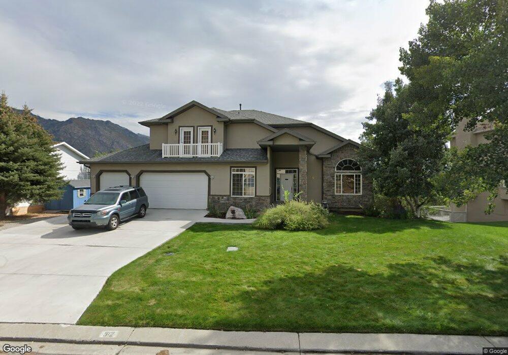
512 Hillside Cir Alpine, UT 84004
Estimated Value: $798,000 - $1,203,406
5
Beds
4
Baths
5,120
Sq Ft
$200/Sq Ft
Est. Value
About This Home
This home is located at 512 Hillside Cir, Alpine, UT 84004 and is currently estimated at $1,022,852, approximately $199 per square foot. 512 Hillside Cir is a home located in Utah County with nearby schools including Westfield School, Timberline Middle School, and Lone Peak High School.
Ownership History
Date
Name
Owned For
Owner Type
Purchase Details
Closed on
Jan 4, 2022
Sold by
James Gibson
Bought by
Gibson Family Trust
Current Estimated Value
Purchase Details
Closed on
Oct 8, 2021
Sold by
Gibson James M and Gibson Sheila
Bought by
Gibson James Morse and Gibson Sheila Diane
Purchase Details
Closed on
Jun 12, 2009
Sold by
Wells Fargo Bank Na
Bought by
Gibson James and Gibson Sheila
Home Financials for this Owner
Home Financials are based on the most recent Mortgage that was taken out on this home.
Original Mortgage
$320,000
Interest Rate
4.83%
Mortgage Type
Purchase Money Mortgage
Purchase Details
Closed on
Oct 31, 2008
Sold by
Joseph Gabriel S
Bought by
Gmac Mortgage Llc
Purchase Details
Closed on
Jun 7, 2005
Sold by
Joseph Gabriel S
Bought by
Newcastle Holdings Llc
Home Financials for this Owner
Home Financials are based on the most recent Mortgage that was taken out on this home.
Original Mortgage
$560,200
Interest Rate
5.72%
Mortgage Type
Seller Take Back
Purchase Details
Closed on
Jul 26, 2004
Sold by
The Philip & Helen Blake Trust and Blake Philip T
Bought by
Joseph Gabriel S
Home Financials for this Owner
Home Financials are based on the most recent Mortgage that was taken out on this home.
Original Mortgage
$325,600
Interest Rate
6.24%
Mortgage Type
Purchase Money Mortgage
Purchase Details
Closed on
Feb 10, 2003
Sold by
Blake Philip T and Blake Helen M
Bought by
Blake Philip T and Blake Helen
Purchase Details
Closed on
Jan 22, 2003
Bought by
Pugh Kenra and Pugh Marva Kay
Purchase Details
Closed on
Dec 6, 2001
Sold by
Blake Philip T and Blake Helen
Bought by
Blake Philip T and Blake Helen M
Purchase Details
Closed on
Jun 19, 1998
Sold by
Blake Philip T and Blake Helen
Bought by
Blake Philip T and Blake Helen
Home Financials for this Owner
Home Financials are based on the most recent Mortgage that was taken out on this home.
Original Mortgage
$227,150
Interest Rate
7.17%
Purchase Details
Closed on
Jun 7, 1996
Sold by
Blake Philip and Blake Marsha
Bought by
Blake Philip T and Blake Helen
Create a Home Valuation Report for This Property
The Home Valuation Report is an in-depth analysis detailing your home's value as well as a comparison with similar homes in the area
Home Values in the Area
Average Home Value in this Area
Purchase History
| Date | Buyer | Sale Price | Title Company |
|---|---|---|---|
| Gibson Family Trust | -- | None Listed On Document | |
| Gibson James Morse | -- | None Available | |
| Gibson James | -- | Guardian Title Company Of U | |
| Gmac Mortgage Llc | $447,813 | Trustees Title & Escrow | |
| Newcastle Holdings Llc | -- | -- | |
| Joseph Gabriel S | -- | Metro National Title | |
| Blake Philip T | -- | -- | |
| Pugh Kenra | -- | -- | |
| Blake Philip T | -- | Equity Title Agency Inc | |
| Blake Philip T | -- | -- | |
| Blake Philip T | -- | -- |
Source: Public Records
Mortgage History
| Date | Status | Borrower | Loan Amount |
|---|---|---|---|
| Previous Owner | Gibson James | $320,000 | |
| Previous Owner | Newcastle Holdings Llc | $560,200 | |
| Previous Owner | Joseph Gabriel S | $325,600 | |
| Previous Owner | Blake Philip T | $227,150 | |
| Closed | Joseph Gabriel S | $81,400 |
Source: Public Records
Tax History
| Year | Tax Paid | Tax Assessment Tax Assessment Total Assessment is a certain percentage of the fair market value that is determined by local assessors to be the total taxable value of land and additions on the property. | Land | Improvement |
|---|---|---|---|---|
| 2025 | $4,365 | $570,515 | -- | -- |
| 2024 | $4,365 | $508,695 | $0 | $0 |
| 2023 | $4,188 | $524,040 | $0 | $0 |
| 2022 | $4,435 | $539,000 | $0 | $0 |
| 2021 | $4,000 | $755,100 | $189,600 | $565,500 |
| 2020 | $3,808 | $703,500 | $164,900 | $538,600 |
| 2019 | $3,202 | $617,500 | $164,900 | $452,600 |
| 2018 | $3,167 | $603,400 | $151,700 | $451,700 |
| 2017 | $2,847 | $288,640 | $0 | $0 |
| 2016 | $2,861 | $270,490 | $0 | $0 |
| 2015 | -- | $236,885 | $0 | $0 |
| 2014 | $2,583 | $228,525 | $0 | $0 |
Source: Public Records
Map
Nearby Homes
- 353 International Way
- 501 W Devey Dr
- 820 Eagleview Dr
- 151 Glacier Lily Dr
- 684 N Summit Way
- 248 Deerfield Dr
- 475 Grove Dr
- 30 S Main St
- 522 N Pfeifferhorn Dr
- 48 N 100 E
- 19 E Elk Ct
- 591 N Pfeifferhorn Dr
- 12513 Timberline Dr
- 259 Twin River Loop
- 512 Eastridge Cir
- 5886 W Timber Ridge Ln
- 128 E Deer Crest Ln Unit 304
- 250 S Main St Unit 25
- 250 S Main St Unit 9
- 250 S Main St Unit 7
- 502 Hillside Cir
- 520 Hillside Cir
- 362 N Hillside Dr
- 543 N Hillside Dr
- 528 Hillside Dr
- 543 Hillside Dr
- 527 Hillside Cir
- 492 Hillside Cir
- 494 N Hillside Dr
- 530 Hillside Cir
- 556 Hillside Dr
- 514 N 400 W
- 536 N 400 W
- 482 N 400 W
- 540 Hillside Cir
- 565 Hillside Cir
- 567 Hillside Dr
- 565 Hillside Dr
- 557 Hillside Cir
- 560 N 400 W
Your Personal Tour Guide
Ask me questions while you tour the home.