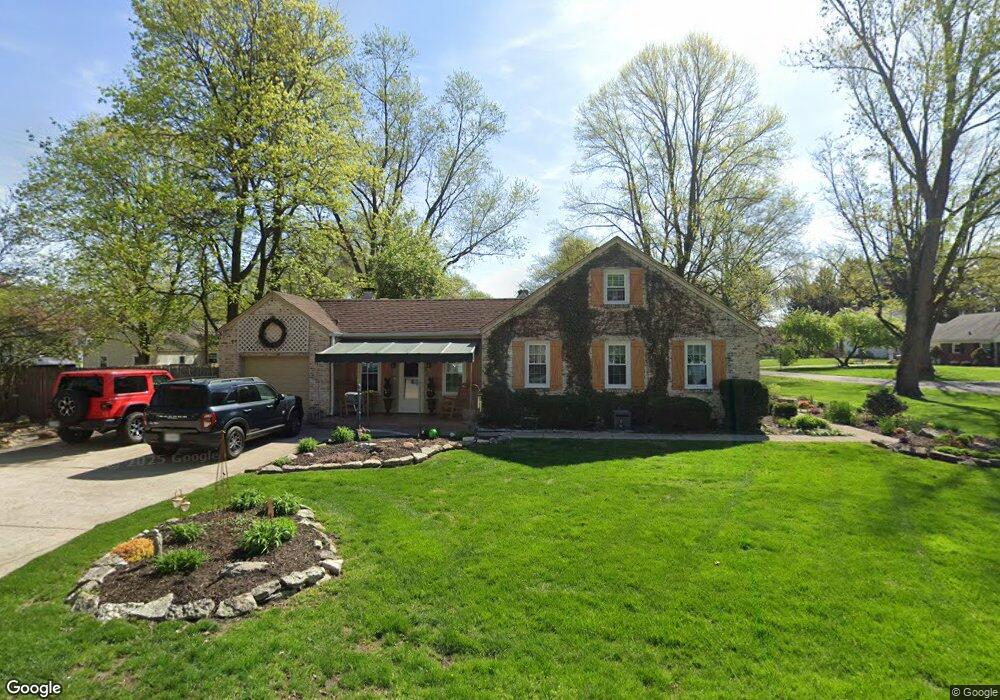
512 Pershing Dr Anderson, IN 46011
Estimated Value: $211,000 - $267,000
4
Beds
1
Bath
1,844
Sq Ft
$130/Sq Ft
Est. Value
About This Home
This home is located at 512 Pershing Dr, Anderson, IN 46011 and is currently estimated at $239,712, approximately $129 per square foot. 512 Pershing Dr is a home located in Madison County with nearby schools including Edgewood Elementary School, Highland Middle School, and Anderson High School.
Ownership History
Date
Name
Owned For
Owner Type
Purchase Details
Closed on
Mar 24, 2025
Sold by
Harrison Thomas S and Harrison Theresa L
Bought by
Thomas Stuart And Theresa Lee Harrison Revoca and Harrison
Current Estimated Value
Purchase Details
Closed on
Oct 21, 2022
Sold by
Harrison Thomas S
Bought by
Harrison Thomas S and Harrison Theresa L
Purchase Details
Closed on
Feb 25, 2022
Sold by
Feller Kimberly H
Bought by
Harrison Thomas S
Purchase Details
Closed on
Mar 29, 2005
Sold by
Davidson Watson Anna A
Bought by
Harrison David J and Feller Kimberly H
Create a Home Valuation Report for This Property
The Home Valuation Report is an in-depth analysis detailing your home's value as well as a comparison with similar homes in the area
Home Values in the Area
Average Home Value in this Area
Purchase History
| Date | Buyer | Sale Price | Title Company |
|---|---|---|---|
| Thomas Stuart And Theresa Lee Harrison Revoca | -- | None Listed On Document | |
| Harrison Thomas S | -- | -- | |
| Harrison Thomas S | -- | Sanaberry Dickman Builta & Coo | |
| Harrison David J | -- | -- |
Source: Public Records
Tax History
| Year | Tax Paid | Tax Assessment Tax Assessment Total Assessment is a certain percentage of the fair market value that is determined by local assessors to be the total taxable value of land and additions on the property. | Land | Improvement |
|---|---|---|---|---|
| 2025 | $1,489 | $148,200 | $17,400 | $130,800 |
| 2024 | $1,489 | $136,600 | $17,400 | $119,200 |
| 2023 | $1,376 | $124,900 | $16,600 | $108,300 |
| 2022 | $1,391 | $125,100 | $15,800 | $109,300 |
| 2021 | $2,598 | $115,100 | $15,700 | $99,400 |
| 2020 | $2,499 | $110,200 | $14,900 | $95,300 |
| 2019 | $2,440 | $107,500 | $14,900 | $92,600 |
| 2018 | $4,471 | $99,400 | $14,900 | $84,500 |
| 2017 | $1,972 | $98,200 | $14,900 | $83,300 |
| 2016 | $5,271 | $94,100 | $14,900 | $79,200 |
| 2014 | $1,922 | $95,600 | $15,200 | $80,400 |
| 2013 | $1,922 | $95,600 | $15,200 | $80,400 |
Source: Public Records
Map
Nearby Homes
- 34 Colony Rd
- 607 Ironwood Ln
- 3628 Woodglen Way
- 1236 Park Rd
- 206 Somerville Rd
- 15 S Creedmoor Way
- 2116 Manger Ln
- 3404 Village Dr
- 1820 Euclid Dr
- 1117 Balfour Rd
- 2825 Brentwood Dr
- 4779 W Lincoln Rd
- 1008 Malibu Dr
- 2308 W 16th St
- 2511 Winterwood Ln
- 2525 Winterwood Ln
- 2519 Winterwood Ln
- 2526 Winterwood Ln
- 2534 Winterwood Ln
- 1516 Fulton St
Your Personal Tour Guide
Ask me questions while you tour the home.