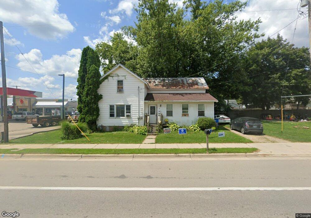
512 S Main St Reading, MI 49274
Estimated Value: $120,000 - $135,837
3
Beds
1
Bath
1,056
Sq Ft
$124/Sq Ft
Est. Value
About This Home
This home is located at 512 S Main St, Reading, MI 49274 and is currently estimated at $131,459, approximately $124 per square foot. 512 S Main St is a home located in Hillsdale County with nearby schools including Reynolds Elementary School, Reading High School, and Cooper Amish School.
Ownership History
Date
Name
Owned For
Owner Type
Purchase Details
Closed on
Dec 15, 2021
Sold by
Mcintyre Misty
Bought by
Bester Tyrone
Current Estimated Value
Purchase Details
Closed on
Dec 21, 2018
Sold by
Clabaugh Christopher A and Clabaugh Melissa L
Bought by
Bester Tyrone and Bester Misty
Purchase Details
Closed on
Jun 13, 2018
Sold by
Brown Larry J and Brown Cristy A
Bought by
Clabaugh Christopher and Clabaugh Melissa
Purchase Details
Closed on
Oct 21, 2016
Sold by
Ilrown Larry J and Brown Cristy A
Bought by
Bester Misty J
Purchase Details
Closed on
Oct 21, 2011
Sold by
Ryan Hilary
Bought by
Brown Larry J and Brown Cristy A
Purchase Details
Closed on
Mar 31, 2011
Sold by
Estate Of Kevin Eric Ryan and Ryan Hilary
Bought by
Ryan Hilary
Purchase Details
Closed on
Mar 2, 1995
Sold by
Bondsteel Katharine R
Bought by
Ryan Kevin E
Create a Home Valuation Report for This Property
The Home Valuation Report is an in-depth analysis detailing your home's value as well as a comparison with similar homes in the area
Purchase History
| Date | Buyer | Sale Price | Title Company |
|---|---|---|---|
| Bester Tyrone | -- | None Available | |
| Bester Tyrone | -- | None Available | |
| Clabaugh Christopher | -- | None Available | |
| Bester Misty J | -- | None Available | |
| Brown Larry J | $10,000 | Midstate Title Agency | |
| Ryan Hilary | -- | None Available | |
| Ryan Kevin E | $22,000 | -- |
Source: Public Records
Tax History
| Year | Tax Paid | Tax Assessment Tax Assessment Total Assessment is a certain percentage of the fair market value that is determined by local assessors to be the total taxable value of land and additions on the property. | Land | Improvement |
|---|---|---|---|---|
| 2025 | $535 | $46,400 | $0 | $0 |
| 2024 | $5 | $45,000 | $0 | $0 |
| 2023 | $499 | $34,200 | $0 | $0 |
| 2022 | $761 | $28,300 | $0 | $0 |
| 2021 | $741 | $27,100 | $0 | $0 |
| 2020 | $7 | $23,900 | $0 | $0 |
| 2019 | $710 | $22,900 | $0 | $0 |
| 2018 | $683 | $22,700 | $0 | $0 |
| 2017 | $662 | $21,800 | $0 | $0 |
| 2016 | $656 | $21,500 | $0 | $0 |
| 2015 | $420 | $21,500 | $0 | $0 |
| 2013 | $407 | $17,340 | $0 | $0 |
| 2012 | $352 | $14,970 | $0 | $0 |
Source: Public Records
Map
Nearby Homes
- 309 S Main St
- 0 W Silver St Unit 25044322
- 226 Strong St
- 0 Long Lake Rd Unit 26458115
- 0 Long Lake Rd Unit 26009910
- 5211 Long Lake Rd
- 4380 Abbott Rd
- 5339 Lake Dr
- 5482 Circle Dr
- 5100 Long Lake Rd
- 7944 Gilmore Rd
- 5375 Paradise Dr
- 4427 Carpenter Rd
- 3870 Rus Dic Dr
- 7535 Popple Ln
- 9949 Indian Trail
- 7841 Topinabee Dr
- 4111 Blair Rd
- 0 Dimmers Rd
- 8875 Kellogg Dr
Your Personal Tour Guide
Ask me questions while you tour the home.