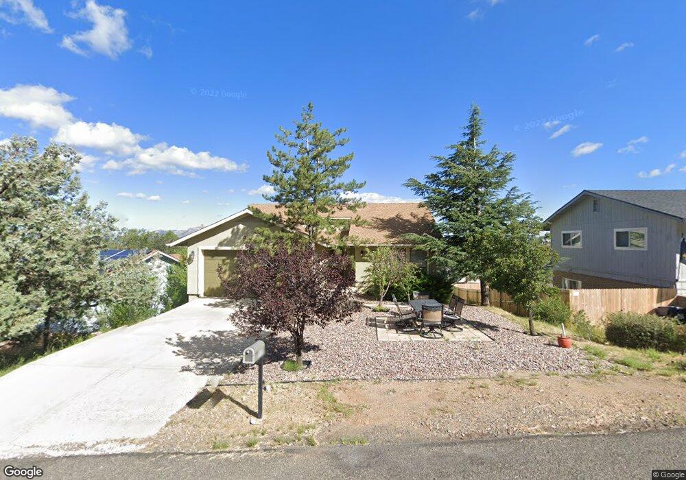
512 S Skyview Cir Prescott, AZ 86303
Estimated Value: $413,207 - $480,000
3
Beds
2
Baths
1,118
Sq Ft
$395/Sq Ft
Est. Value
About This Home
This home is located at 512 S Skyview Cir, Prescott, AZ 86303 and is currently estimated at $441,552, approximately $394 per square foot. 512 S Skyview Cir is a home located in Yavapai County with nearby schools including Taylor Hicks School, Granite Mountain Middle School, and Prescott Mile High Middle School.
Ownership History
Date
Name
Owned For
Owner Type
Purchase Details
Closed on
Apr 24, 2003
Sold by
Almutawa Subhi and Almutawa Linda
Bought by
Brown Thomas P
Current Estimated Value
Home Financials for this Owner
Home Financials are based on the most recent Mortgage that was taken out on this home.
Original Mortgage
$74,900
Outstanding Balance
$32,177
Interest Rate
5.75%
Mortgage Type
Purchase Money Mortgage
Estimated Equity
$409,375
Purchase Details
Closed on
Feb 23, 2001
Sold by
Schneider Devendorf Joan P
Bought by
Al Mutawa Subhi and Al Mutawa Linda
Create a Home Valuation Report for This Property
The Home Valuation Report is an in-depth analysis detailing your home's value as well as a comparison with similar homes in the area
Home Values in the Area
Average Home Value in this Area
Purchase History
| Date | Buyer | Sale Price | Title Company |
|---|---|---|---|
| Brown Thomas P | $151,900 | Transnation Title Insurance | |
| Al Mutawa Subhi | $111,000 | Capital Title Agency Inc |
Source: Public Records
Mortgage History
| Date | Status | Borrower | Loan Amount |
|---|---|---|---|
| Open | Brown Thomas P | $74,900 |
Source: Public Records
Tax History Compared to Growth
Tax History
| Year | Tax Paid | Tax Assessment Tax Assessment Total Assessment is a certain percentage of the fair market value that is determined by local assessors to be the total taxable value of land and additions on the property. | Land | Improvement |
|---|---|---|---|---|
| 2026 | $919 | $28,863 | -- | -- |
| 2024 | $847 | $28,505 | -- | -- |
| 2023 | $878 | $24,224 | $6,994 | $17,230 |
| 2022 | $847 | $20,631 | $6,517 | $14,114 |
| 2021 | $860 | $19,854 | $5,685 | $14,169 |
| 2020 | $838 | $0 | $0 | $0 |
| 2019 | $812 | $0 | $0 | $0 |
| 2018 | $763 | $0 | $0 | $0 |
| 2017 | $718 | $0 | $0 | $0 |
| 2016 | $692 | $0 | $0 | $0 |
| 2015 | $655 | $0 | $0 | $0 |
| 2014 | -- | $0 | $0 | $0 |
Source: Public Records
Map
Nearby Homes
- 1203 McDonald Dr
- 1284 McDonald Dr
- 1228 McDonald Dr Unit 1/2
- 1228 McDonald Dr Unit 52
- 1228 McDonald Dr
- 450 Broadview Dr
- 432 Newport Dr Unit 86
- 395 Newport Dr
- 386 Newport Dr
- 500 Broadview Dr
- 277 Jacob Ln
- 000 S Canyon Dr
- 1300 Newport Ridge Dr Unit 116
- 1300 Newport Ridge Dr
- 550 Eastwood Place
- 300 Newport Dr
- 872 Spring Trail
- 631 S Canyon Dr E
- 1238 Jordin Dr Unit 60
- 1232 Jordin Dr
- 512 S Skyview Cir
- 580 S Skyview Dr
- 506 S Skyview Cir
- 585 S Bradshaw Dr
- 576 Skyview Dr
- 507 S Skyview Cir
- 582 S Skyview Dr
- 572 S Skyview Dr
- 575 S Bradshaw Dr
- 505 S Skyview Cir
- 507 S Bradshaw Dr
- 570 S Skyview Dr
- 565 S Bradshaw Dr
- 506 S Skyview Dr
- 513 S Bradshaw Dr
- 0 S Bradshaw Dr Unit PAR897809
- 0 S Bradshaw Dr Unit PAR370873
- 0 S Bradshaw Dr Unit PAR374307
- 0 S Bradshaw Dr Unit 991847
- 0 S Bradshaw Dr Unit 993426