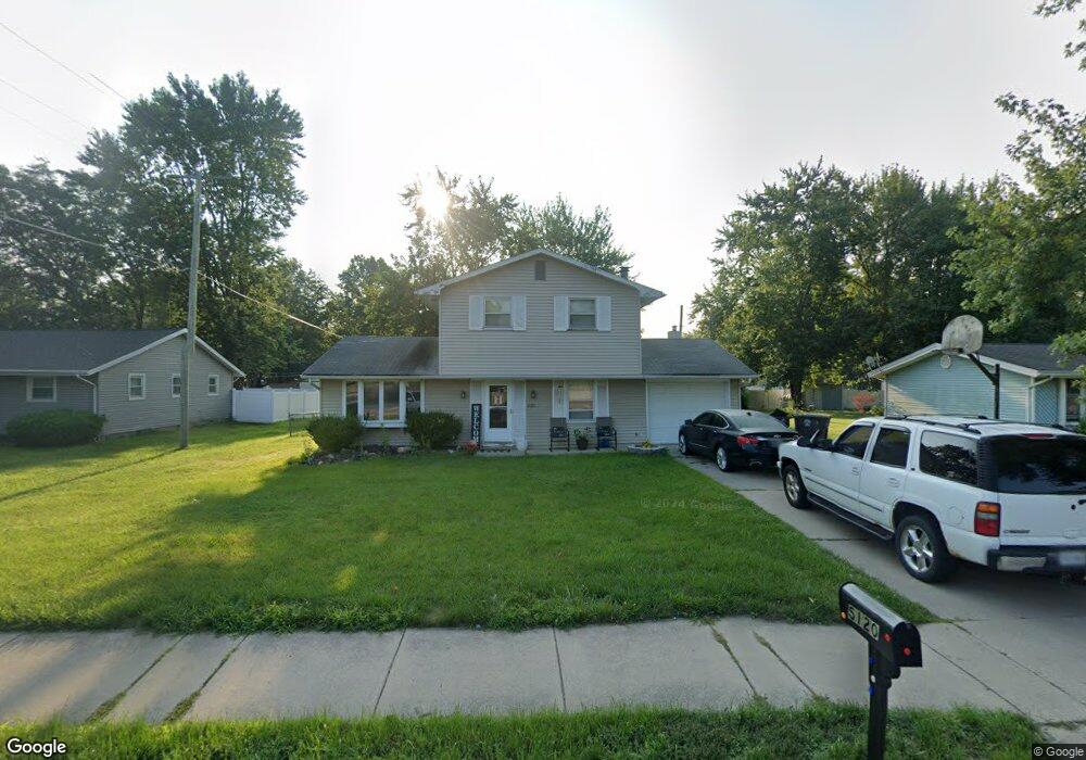
5120 Maplecrest Rd Fort Wayne, IN 46835
Maplewood NeighborhoodEstimated Value: $206,000 - $229,000
3
Beds
2
Baths
1,432
Sq Ft
$150/Sq Ft
Est. Value
About This Home
This home is located at 5120 Maplecrest Rd, Fort Wayne, IN 46835 and is currently estimated at $215,353, approximately $150 per square foot. 5120 Maplecrest Rd is a home located in Allen County with nearby schools including Saint Joseph Central School, Jefferson Middle School, and Northrop High School.
Ownership History
Date
Name
Owned For
Owner Type
Purchase Details
Closed on
Oct 31, 2006
Sold by
Frain Dustin S and Frain Brandalyn K
Bought by
Hurse Corey L and Hurse Molly M
Current Estimated Value
Home Financials for this Owner
Home Financials are based on the most recent Mortgage that was taken out on this home.
Original Mortgage
$83,700
Outstanding Balance
$49,456
Interest Rate
6.47%
Mortgage Type
Stand Alone First
Estimated Equity
$165,897
Create a Home Valuation Report for This Property
The Home Valuation Report is an in-depth analysis detailing your home's value as well as a comparison with similar homes in the area
Home Values in the Area
Average Home Value in this Area
Purchase History
| Date | Buyer | Sale Price | Title Company |
|---|---|---|---|
| Hurse Corey L | -- | Metropolitan Title Company |
Source: Public Records
Mortgage History
| Date | Status | Borrower | Loan Amount |
|---|---|---|---|
| Open | Hurse Corey L | $83,700 |
Source: Public Records
Tax History
| Year | Tax Paid | Tax Assessment Tax Assessment Total Assessment is a certain percentage of the fair market value that is determined by local assessors to be the total taxable value of land and additions on the property. | Land | Improvement |
|---|---|---|---|---|
| 2025 | $2,037 | $202,100 | $31,400 | $170,700 |
| 2024 | $1,934 | $182,500 | $31,400 | $151,100 |
| 2022 | $1,725 | $155,500 | $31,400 | $124,100 |
| 2021 | $1,592 | $144,400 | $20,600 | $123,800 |
| 2020 | $1,367 | $126,800 | $20,600 | $106,200 |
| 2019 | $1,315 | $122,600 | $20,600 | $102,000 |
| 2018 | $1,172 | $111,300 | $20,600 | $90,700 |
| 2017 | $1,034 | $102,000 | $20,600 | $81,400 |
| 2016 | $1,038 | $101,900 | $20,600 | $81,300 |
| 2014 | $894 | $95,500 | $20,600 | $74,900 |
| 2013 | $783 | $90,500 | $20,600 | $69,900 |
Source: Public Records
Map
Nearby Homes
- 6537 Arnel Ave
- 6033 Bohde Trail
- 6830 Elmbrook Dr
- 5318 Keswick Ln
- 5703 Dennison Dr
- 5320 Willman Ln
- 4615 Beechcrest Dr
- 5214 Eicher Dr
- 5516 Newland Place
- 6508 Birchdale Dr
- 6823 Creekwood Trail
- 7219 Putt Ln
- 5323 Blossom Ridge
- 5424 Thornbriar Ln
- 7017 Saint Joe Center Rd
- 6216 Hunter Wood Dr
- 6327 Hunter Wood Dr
- 5925 Gate Tree Ln
- 5317 Stellhorn Rd
- 5433 Hewitt Ln
- 5116 Maplecrest Rd
- 5124 Maplecrest Rd
- 6315 Bellefield Dr
- 6323 Bellefield Dr
- 5106 Maplecrest Rd
- 6304 Arnel Ave
- 6329 Bellefield Dr
- 6320 Arnel Ave
- 6213 Groveland Dr
- 6406 Arnel Ave
- 6335 Bellefield Dr
- 6214 Pheasant Pass
- 6214 Groveland Dr
- 6204 Pheasant Pass
- 5032 Maplecrest Rd
- 6310 Bellefield Dr
- 6326 Bellefield Dr
- 6318 Bellefield Dr
- 6332 Bellefield Dr
- 6203 Groveland Dr
Your Personal Tour Guide
Ask me questions while you tour the home.