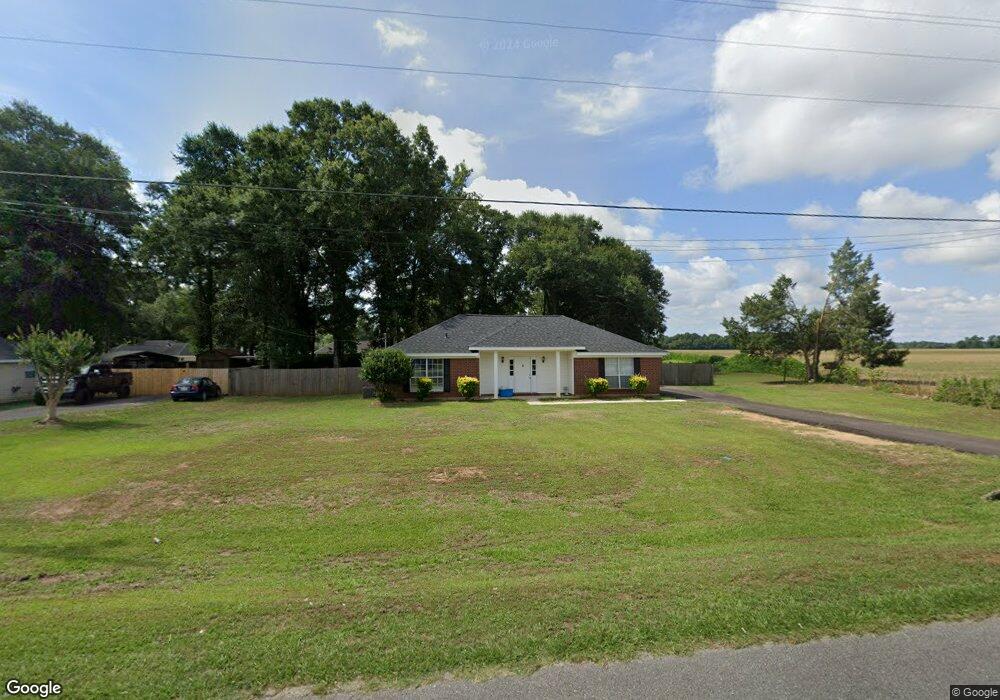
5123 Dawes Rd Grand Bay, AL 36541
Union Church NeighborhoodEstimated Value: $211,607 - $272,000
3
Beds
2
Baths
1,580
Sq Ft
$159/Sq Ft
Est. Value
About This Home
This home is located at 5123 Dawes Rd, Grand Bay, AL 36541 and is currently estimated at $250,902, approximately $158 per square foot. 5123 Dawes Rd is a home located in Mobile County with nearby schools including Meadowlake Elementary School, Grand Bay Middle School, and Alma Bryant High School.
Ownership History
Date
Name
Owned For
Owner Type
Purchase Details
Closed on
May 26, 1999
Sold by
Southern Oaks Llc
Bought by
Greg Stewart Homes Inc
Current Estimated Value
Purchase Details
Closed on
Nov 16, 1998
Sold by
H & P Ltd
Bought by
Krause Charles J and Krause Stacy M
Home Financials for this Owner
Home Financials are based on the most recent Mortgage that was taken out on this home.
Original Mortgage
$87,423
Interest Rate
6.47%
Mortgage Type
FHA
Create a Home Valuation Report for This Property
The Home Valuation Report is an in-depth analysis detailing your home's value as well as a comparison with similar homes in the area
Home Values in the Area
Average Home Value in this Area
Purchase History
| Date | Buyer | Sale Price | Title Company |
|---|---|---|---|
| Greg Stewart Homes Inc | -- | -- | |
| Krause Charles J | -- | -- | |
| H & P Ltd | -- | -- |
Source: Public Records
Mortgage History
| Date | Status | Borrower | Loan Amount |
|---|---|---|---|
| Previous Owner | Krause Charles J | $87,423 |
Source: Public Records
Tax History Compared to Growth
Tax History
| Year | Tax Paid | Tax Assessment Tax Assessment Total Assessment is a certain percentage of the fair market value that is determined by local assessors to be the total taxable value of land and additions on the property. | Land | Improvement |
|---|---|---|---|---|
| 2024 | $1,635 | $32,260 | $6,300 | $25,960 |
| 2023 | $1,635 | $29,100 | $7,560 | $21,540 |
| 2022 | $1,314 | $27,100 | $6,740 | $20,360 |
| 2021 | $1,188 | $24,500 | $6,300 | $18,200 |
| 2020 | $1,199 | $24,720 | $6,300 | $18,420 |
| 2019 | $1,224 | $25,240 | $7,360 | $17,880 |
| 2018 | $1,235 | $25,460 | $0 | $0 |
| 2017 | $1,284 | $25,040 | $0 | $0 |
| 2016 | $1,224 | $25,240 | $0 | $0 |
| 2013 | $574 | $12,400 | $0 | $0 |
Source: Public Records
Map
Nearby Homes
- 10445 Patrick Ave
- 0 Wear Rd
- 0 Wear Rd Unit 7583928
- 5190 Lods Field Rd
- 5269 Dawes Rd
- 4376 Baird Coxwell Rd
- 9501 Ben Hamilton Rd
- 0 McCovery Rd
- 4256 Baird Coxwell Rd
- 4236 Baird Coxwell Rd
- 4246 Baird Coxwell Rd
- 4236 Baird Coxwell Rd
- 10735 Mcleod Rd
- 10124 Crossley Hill Dr
- 11555 Jack Hamilton Rd
- 00 Dawes Rd
- 0 Windy Leaf Dr Unit 7447401
- 0 Windy Leaf Dr Unit 7013459
- 0 Windy Leaf Dr Unit 7013447
- 0 Windy Leaf Dr Unit 7013427
- 5117 Dawes Rd
- 10789 Southern Oaks Ct
- 5113 Dawes Rd
- 10779 Southern Oaks Ct
- 5107 Dawes Rd
- 10778 Southern Oaks Ct Unit 2
- 10769 Southern Oaks Ct
- 5103 Dawes Rd
- 10704 Deakle Ct
- 10768 Southern Oaks Ct Unit 2
- 10759 Southern Oaks Ct
- 10694 Deakle Ct
- 5097 Dawes Rd
- 10749 Southern Oaks Ct
- 10749 Southern Oaks Ct Unit 29
- 10703 Deakle Ct
- 10758 Southern Oaks Ct
- 10684 Deakle Ct Unit 2
- 10739 Southern Oaks Ct
- 5093 Dawes Rd