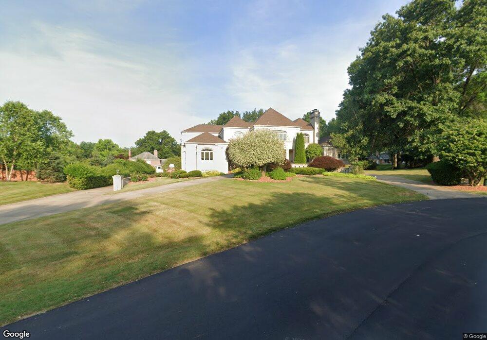
5125 Birkdale St NW Canton, OH 44708
Estimated Value: $1,014,000 - $1,194,989
5
Beds
7
Baths
6,639
Sq Ft
$162/Sq Ft
Est. Value
About This Home
This home is located at 5125 Birkdale St NW, Canton, OH 44708 and is currently estimated at $1,076,747, approximately $162 per square foot. 5125 Birkdale St NW is a home located in Stark County with nearby schools including Lake Cable Elementary School, Jackson Memorial Middle School, and Jackson High School.
Ownership History
Date
Name
Owned For
Owner Type
Purchase Details
Closed on
Aug 4, 2010
Sold by
Birkdale Property Llc
Bought by
Patibandla Sujana K
Current Estimated Value
Purchase Details
Closed on
Dec 30, 2009
Sold by
Patibandla Sujana K and Patibandla Prasad A
Bought by
Birkdale Property Llc
Purchase Details
Closed on
Aug 25, 1988
Create a Home Valuation Report for This Property
The Home Valuation Report is an in-depth analysis detailing your home's value as well as a comparison with similar homes in the area
Home Values in the Area
Average Home Value in this Area
Purchase History
| Date | Buyer | Sale Price | Title Company |
|---|---|---|---|
| Patibandla Sujana K | -- | Attorney | |
| Birkdale Property Llc | -- | Attorney | |
| -- | $61,500 | -- |
Source: Public Records
Tax History Compared to Growth
Tax History
| Year | Tax Paid | Tax Assessment Tax Assessment Total Assessment is a certain percentage of the fair market value that is determined by local assessors to be the total taxable value of land and additions on the property. | Land | Improvement |
|---|---|---|---|---|
| 2025 | -- | $379,410 | $46,450 | $332,960 |
| 2024 | -- | $379,410 | $46,450 | $332,960 |
| 2023 | $17,590 | $362,740 | $39,200 | $323,540 |
| 2022 | $8,757 | $362,740 | $39,200 | $323,540 |
| 2021 | $17,581 | $362,740 | $39,200 | $323,540 |
| 2020 | $15,450 | $294,670 | $33,850 | $260,820 |
| 2019 | $14,881 | $294,670 | $33,850 | $260,820 |
| 2018 | $14,956 | $294,670 | $33,850 | $260,820 |
| 2017 | $15,351 | $287,990 | $25,870 | $262,120 |
| 2016 | $15,453 | $287,990 | $25,870 | $262,120 |
| 2015 | $15,643 | $287,990 | $25,870 | $262,120 |
| 2014 | $1,189 | $268,040 | $24,090 | $243,950 |
| 2013 | $7,466 | $268,040 | $24,090 | $243,950 |
Source: Public Records
Map
Nearby Homes
- 5179 Birkdale St NW
- 0 Birkdale St NW Unit 5122150
- 2421 Brentwood Rd NW
- 2450 Larchmoor Pkwy NW
- 0 Dunkeith Dr NW Unit 5083845
- 1805 Dunkeith Dr NW
- 2742 Dunkeith Dr NW
- 3273 Dellwood Ave NW
- 5606 Hensley St NW
- 2622 Glenmont Rd NW
- 0 Hills And Dales Rd NW Unit 5138797
- 5851 Hawks Nest Cir NW
- 5853 Hawks Nest Cir NW
- 5430 Severn Cir NW
- 5845 Hawks Nest Cir NW
- 5364 Burlawn St NW
- 5843 Hawks Nest Cir NW
- VL Woodlawn Ave NW
- 1702 Thornridge Rd NW
- 5867 Hawks Nest Cir NW
- 5139 Birkdale St NW
- 5115 Birkdale St NW
- 5380 Saint Andrews St NW
- 5420 Saint Andrews St NW
- 5114 Birkdale St NW
- 0 Birkdale St NW Unit 3961793
- 5350 Saint Andrews St NW
- Lot 5 Saint Andrews St NW
- 5155 Birkdale St NW
- 5454 Saint Andrews St NW
- 5224 Saint Andrews St NW
- 5282 Saint Andrews St NW
- 5154 Birkdale St NW
- 5340 Saint Andrews St NW
- 5419 Saint Andrews St NW
- 5381 Saint Andrews St NW
- 5192 Saint Andrews St NW
- 5455 Saint Andrews St NW
- 5351 Saint Andrews St NW
- 5345 Saint Andrews St NW