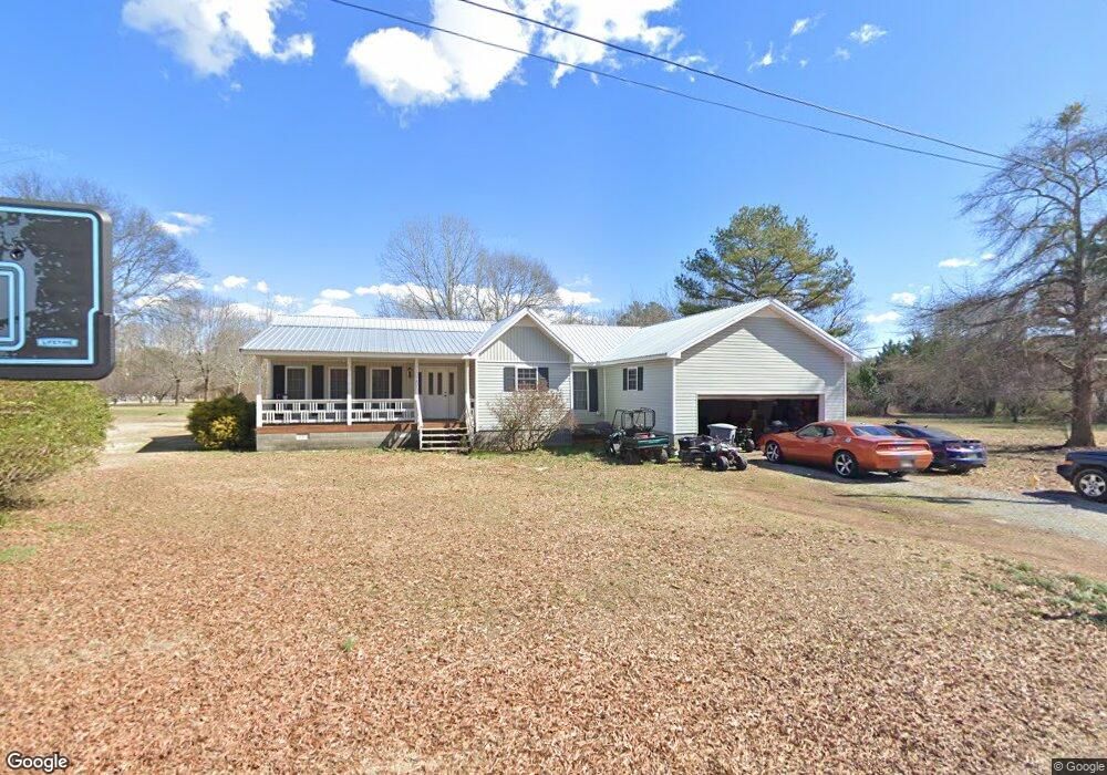
5127 Sewell Ferry Rd Cedar Bluff, AL 35959
Estimated Value: $271,411 - $403,000
3
Beds
3
Baths
1,560
Sq Ft
$210/Sq Ft
Est. Value
About This Home
This home is located at 5127 Sewell Ferry Rd, Cedar Bluff, AL 35959 and is currently estimated at $328,103, approximately $210 per square foot. 5127 Sewell Ferry Rd is a home located in Cherokee County with nearby schools including Cherokee County High School.
Ownership History
Date
Name
Owned For
Owner Type
Purchase Details
Closed on
May 24, 2017
Sold by
Covington Daphanie E
Bought by
Covington James T
Current Estimated Value
Purchase Details
Closed on
Jun 20, 2011
Sold by
Fannie Mae
Bought by
Covington Daphanie E and Covington James T
Home Financials for this Owner
Home Financials are based on the most recent Mortgage that was taken out on this home.
Original Mortgage
$87,718
Interest Rate
4.5%
Mortgage Type
FHA
Create a Home Valuation Report for This Property
The Home Valuation Report is an in-depth analysis detailing your home's value as well as a comparison with similar homes in the area
Home Values in the Area
Average Home Value in this Area
Purchase History
| Date | Buyer | Sale Price | Title Company |
|---|---|---|---|
| Covington James T | -- | None Available | |
| Covington Daphanie E | $90,000 | -- |
Source: Public Records
Mortgage History
| Date | Status | Borrower | Loan Amount |
|---|---|---|---|
| Previous Owner | Covington Daphanie E | $87,718 |
Source: Public Records
Tax History Compared to Growth
Tax History
| Year | Tax Paid | Tax Assessment Tax Assessment Total Assessment is a certain percentage of the fair market value that is determined by local assessors to be the total taxable value of land and additions on the property. | Land | Improvement |
|---|---|---|---|---|
| 2025 | $1,491 | $31,720 | $880 | $30,840 |
| 2024 | $1,491 | $31,720 | $880 | $30,840 |
| 2023 | $1,491 | $31,720 | $0 | $0 |
| 2022 | $1,491 | $31,720 | $880 | $30,840 |
| 2021 | $1,206 | $25,660 | $800 | $24,860 |
| 2020 | $1,244 | $26,460 | $800 | $25,660 |
| 2019 | $1,244 | $26,460 | $800 | $25,660 |
| 2018 | $1,244 | $26,460 | $0 | $0 |
| 2017 | $465 | $110,180 | $0 | $0 |
| 2016 | $465 | $110,180 | $0 | $0 |
| 2015 | $465 | $110,180 | $0 | $0 |
| 2014 | $450 | $107,000 | $0 | $0 |
| 2013 | $450 | $107,000 | $0 | $0 |
Source: Public Records
Map
Nearby Homes
- 3899 Hidden Cove Rd
- 3293 Old Highway 9
- 3700 Quail Run Dr
- 0 Hwy 9 Unit 25236460
- 5424 Hidden Point Dr
- 4545 Lawrence St
- 3152 Dykes Bridge Rd Unit 205
- 3152 Dykes Bridge Rd Unit 406
- 3152 Dykes Bridge Rd Unit 304
- 3152 Dykes Bridge Rd Unit 102
- 3152 Reese St
- Lots 20 & 21 Moneys Bend Section 5
- lot Moneys Bend Rd
- EE Moneys Bend Rd
- GG Moneys Bend Rd
- CC Moneys Bend Rd
- FF Moneys Bend Rd
- DD Moneys Bend Rd
- HH Moneys Bend Rd Unit HH
- 2669 Savannah Dr
- 5148 Sewell Ferry Rd
- 5148 Sewell Ferry Rd Unit A 4
- 5148 Sewell Ferry Rd Unit 7A
- 5148 Sewell Ferry Rd Unit RD
- 5148 Sewell Ferry Rd Unit 1
- 5119 Sewell Ferry Rd
- 5130 Sewell Ferry Rd
- 5160 Hidden Cove Rd
- 5170 Hidden Cove Ln
- 53 Hidden Cove Ln
- A Riverpointe Dr
- 26 Lakeside Ln
- 35 Lakeside Dr
- 33 Lakeside Dr
- 5210 Sewell Ferry Rd
- 5080 Sewell Ferry Rd
- A River Point
- 5200 Hidden Cove Cir
- 3795 Cove Ln
- 5081 Sewell Ferry Rd