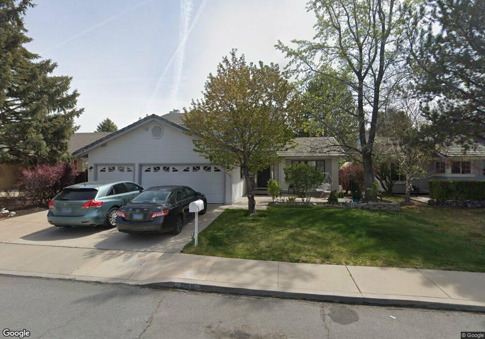
5129 Palo Alto Ct Sparks, NV 89436
Los Altos Parkway NeighborhoodEstimated Value: $591,000 - $603,794
4
Beds
3
Baths
2,372
Sq Ft
$252/Sq Ft
Est. Value
About This Home
This home is located at 5129 Palo Alto Ct, Sparks, NV 89436 and is currently estimated at $597,699, approximately $251 per square foot. 5129 Palo Alto Ct is a home located in Washoe County with nearby schools including Bud Beasley Elementary School, Edward C Reed High School, and Excel Christian School.
Ownership History
Date
Name
Owned For
Owner Type
Purchase Details
Closed on
Feb 8, 2010
Sold by
Gonzalez Javier and Gonzalez Lidia
Bought by
Rathmann Joseph Paul
Current Estimated Value
Home Financials for this Owner
Home Financials are based on the most recent Mortgage that was taken out on this home.
Original Mortgage
$171,770
Outstanding Balance
$116,323
Interest Rate
5.5%
Mortgage Type
FHA
Estimated Equity
$481,376
Purchase Details
Closed on
Oct 20, 2004
Sold by
Armbrust Robert A and Armbrust Pamela E
Bought by
Gonzalez Javier and Gonzalez Lidia
Home Financials for this Owner
Home Financials are based on the most recent Mortgage that was taken out on this home.
Original Mortgage
$333,700
Interest Rate
5%
Mortgage Type
Unknown
Create a Home Valuation Report for This Property
The Home Valuation Report is an in-depth analysis detailing your home's value as well as a comparison with similar homes in the area
Home Values in the Area
Average Home Value in this Area
Purchase History
| Date | Buyer | Sale Price | Title Company |
|---|---|---|---|
| Rathmann Joseph Paul | $178,000 | First Centennial Reno | |
| Gonzalez Javier | $390,000 | Western Title Incorporated |
Source: Public Records
Mortgage History
| Date | Status | Borrower | Loan Amount |
|---|---|---|---|
| Open | Rathmann Joseph Paul | $171,770 | |
| Previous Owner | Gonzalez Javier | $333,700 |
Source: Public Records
Tax History Compared to Growth
Tax History
| Year | Tax Paid | Tax Assessment Tax Assessment Total Assessment is a certain percentage of the fair market value that is determined by local assessors to be the total taxable value of land and additions on the property. | Land | Improvement |
|---|---|---|---|---|
| 2025 | $2,982 | $109,478 | $40,432 | $69,046 |
| 2024 | $2,895 | $108,354 | $38,071 | $70,282 |
| 2023 | $2,895 | $103,755 | $36,775 | $66,981 |
| 2022 | $2,811 | $87,460 | $31,189 | $56,272 |
| 2021 | $2,731 | $79,030 | $22,643 | $56,387 |
| 2020 | $2,648 | $79,455 | $22,610 | $56,845 |
| 2019 | $2,571 | $77,787 | $23,142 | $54,645 |
| 2018 | $2,496 | $70,683 | $16,891 | $53,792 |
| 2017 | $2,424 | $69,832 | $15,628 | $54,204 |
| 2016 | $1,776 | $70,815 | $13,799 | $57,016 |
| 2015 | $1,771 | $69,313 | $12,236 | $57,077 |
| 2014 | $2,290 | $65,444 | $10,341 | $55,103 |
| 2013 | -- | $60,060 | $8,479 | $51,581 |
Source: Public Records
Map
Nearby Homes
- 5276 Santa Rosa Ave
- 1716 Canyon Terrace Dr
- 1388 Lambrays Ln
- 5105 Santa Anita Dr
- 1560 Freeman Way
- 1685 Southview Dr
- 1304 Lambrusca Dr
- 1550 Istrice Rd
- 3693 Vista Blvd
- 1215 Ebling Dr
- 4788 Ravello Dr
- 4675 Firtree Ln
- 5436 Vista Terrace Ln Unit 2B
- 4748 Pradera St
- 4950 San Diego Ct
- 5049 Keams Ct
- 4393 Acobat Ct
- 5780 Camino Verde Dr Unit 105
- 5688 Spandrell Cir
- 1850 Almonte Ct
- 5131 Palo Alto Ct Unit 1
- 5127 Palo Alto Ct
- 5135 Palo Alto Ct
- 5125 Palo Alto Ct
- 5111 Palo Alto Ct
- 5109 Palo Alto Ct Unit 1
- 5115 Palo Alto Ct
- 5121 Palo Alto Ct Unit 1
- 5105 Palo Alto Ct
- 5117 Palo Alto Ct
- 5119 Palo Alto Ct
- 5163 Orinda Ct
- 5157 Palo Alto Cir
- 5095 Palo Alto Cir
- 5165 Orinda Ct
- 5146 Palo Alto Cir
- 5136 Palo Alto Cir
- 5126 Palo Alto Cir
- 5161 Orinda Ct
- 5106 Palo Alto Cir