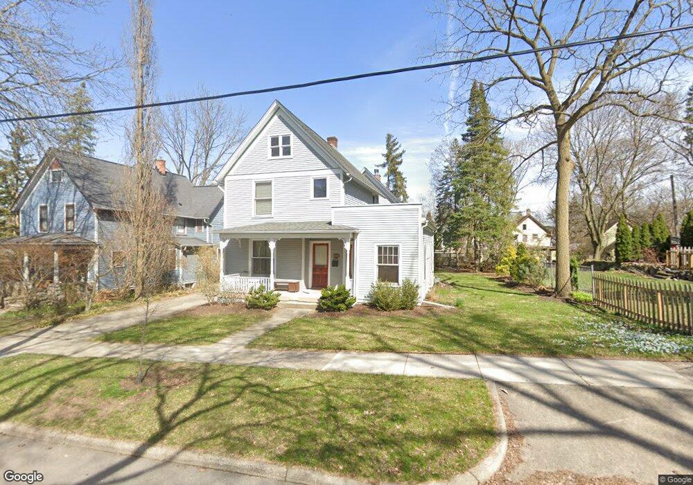
513 4th St Ann Arbor, MI 48103
Old West Side NeighborhoodEstimated Value: $1,228,587 - $1,415,000
4
Beds
3
Baths
2,600
Sq Ft
$516/Sq Ft
Est. Value
About This Home
This home is located at 513 4th St, Ann Arbor, MI 48103 and is currently estimated at $1,341,647, approximately $516 per square foot. 513 4th St is a home located in Washtenaw County with nearby schools including Bach Elementary School, Slauson Middle School, and Pioneer High School.
Ownership History
Date
Name
Owned For
Owner Type
Purchase Details
Closed on
Dec 14, 2007
Sold by
Levleit William F and Levleit Christina Schroeder
Bought by
Bradley David J and Frei Nicole R
Current Estimated Value
Home Financials for this Owner
Home Financials are based on the most recent Mortgage that was taken out on this home.
Original Mortgage
$417,000
Outstanding Balance
$264,080
Interest Rate
6.31%
Mortgage Type
Purchase Money Mortgage
Estimated Equity
$1,077,567
Purchase Details
Closed on
Nov 6, 2006
Sold by
Gaston George Hugh
Bought by
Levleit William F and Levleit Christina Schroeder
Create a Home Valuation Report for This Property
The Home Valuation Report is an in-depth analysis detailing your home's value as well as a comparison with similar homes in the area
Home Values in the Area
Average Home Value in this Area
Purchase History
| Date | Buyer | Sale Price | Title Company |
|---|---|---|---|
| Bradley David J | $700,000 | None Available | |
| Levleit William F | $195,000 | None Available |
Source: Public Records
Mortgage History
| Date | Status | Borrower | Loan Amount |
|---|---|---|---|
| Open | Bradley David J | $417,000 |
Source: Public Records
Tax History Compared to Growth
Tax History
| Year | Tax Paid | Tax Assessment Tax Assessment Total Assessment is a certain percentage of the fair market value that is determined by local assessors to be the total taxable value of land and additions on the property. | Land | Improvement |
|---|---|---|---|---|
| 2025 | $15,805 | $543,400 | $0 | $0 |
| 2024 | $15,415 | $517,900 | $0 | $0 |
| 2023 | $14,214 | $459,900 | $0 | $0 |
| 2022 | $15,489 | $455,900 | $0 | $0 |
| 2021 | $15,124 | $444,900 | $0 | $0 |
| 2020 | $14,818 | $428,800 | $0 | $0 |
| 2019 | $14,102 | $420,200 | $420,200 | $0 |
| 2018 | $13,904 | $360,200 | $0 | $0 |
| 2017 | $13,525 | $374,700 | $0 | $0 |
| 2016 | $13,049 | $270,455 | $0 | $0 |
| 2015 | $12,427 | $269,647 | $0 | $0 |
| 2014 | $12,427 | $261,222 | $0 | $0 |
| 2013 | -- | $261,222 | $0 | $0 |
Source: Public Records
Map
Nearby Homes
- 533 5th St
- 552 5th St
- 814 W Jefferson St
- 220 W Mosley St
- 441 S Ashley St Unit 405
- 717 W Liberty St
- 140 Ashley Mews Dr Unit 27
- 614 S 7th St
- 404 W Liberty St
- 285 Mulholland St Unit 3
- 103 W Davis Ave
- 220 S 7th St
- 111 N Ashley St Unit 513
- 407 Pauline Blvd
- 116 N 7th St
- 1134 Hutchins Ave
- 212 Miller Ave Unit 102
- 212 Miller Ave Unit 203
- 212 Miller Ave Unit 302
- 212 Miller Ave Unit 101