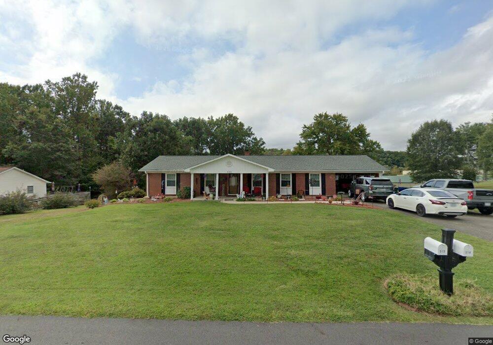
513 E Devon Dr Mount Airy, NC 27030
Estimated Value: $260,292 - $296,000
3
Beds
2
Baths
2,156
Sq Ft
$129/Sq Ft
Est. Value
About This Home
This home is located at 513 E Devon Dr, Mount Airy, NC 27030 and is currently estimated at $278,323, approximately $129 per square foot. 513 E Devon Dr is a home located in Surry County with nearby schools including Bruce H. Tharrington Elementary School, Mount Airy Middle School, and Mount Airy High School.
Ownership History
Date
Name
Owned For
Owner Type
Purchase Details
Closed on
Nov 26, 2008
Sold by
Taylor Kaye Darlene
Bought by
Taylor Kaye Darlene and Taylor Philip Daniel
Current Estimated Value
Home Financials for this Owner
Home Financials are based on the most recent Mortgage that was taken out on this home.
Original Mortgage
$130,202
Outstanding Balance
$86,725
Interest Rate
6.38%
Mortgage Type
Purchase Money Mortgage
Estimated Equity
$191,598
Purchase Details
Closed on
Sep 25, 2006
Sold by
Nguyen Tony Van Le
Bought by
Johnson Arthur A
Home Financials for this Owner
Home Financials are based on the most recent Mortgage that was taken out on this home.
Original Mortgage
$162,000
Interest Rate
6.48%
Mortgage Type
New Conventional
Purchase Details
Closed on
Jun 1, 2001
Create a Home Valuation Report for This Property
The Home Valuation Report is an in-depth analysis detailing your home's value as well as a comparison with similar homes in the area
Purchase History
| Date | Buyer | Sale Price | Title Company |
|---|---|---|---|
| Taylor Kaye Darlene | -- | None Available | |
| Johnson Arthur A | $162,000 | None Available | |
| -- | $135,000 | -- |
Source: Public Records
Mortgage History
| Date | Status | Borrower | Loan Amount |
|---|---|---|---|
| Open | Taylor Kaye Darlene | $130,202 | |
| Previous Owner | Johnson Arthur A | $162,000 |
Source: Public Records
Tax History
| Year | Tax Paid | Tax Assessment Tax Assessment Total Assessment is a certain percentage of the fair market value that is determined by local assessors to be the total taxable value of land and additions on the property. | Land | Improvement |
|---|---|---|---|---|
| 2025 | $918 | $188,860 | $18,000 | $170,860 |
| 2024 | $818 | $155,420 | $14,000 | $141,420 |
| 2023 | $805 | $155,420 | $14,000 | $141,420 |
| 2022 | $805 | $155,420 | $14,000 | $141,420 |
| 2021 | $818 | $155,420 | $14,000 | $141,420 |
| 2020 | $794 | $143,970 | $14,000 | $129,970 |
| 2019 | $791 | $143,970 | $0 | $0 |
| 2018 | $778 | $143,970 | $0 | $0 |
| 2017 | $788 | $143,970 | $0 | $0 |
| 2016 | $777 | $143,970 | $0 | $0 |
| 2013 | -- | $143,660 | $0 | $0 |
Source: Public Records
Map
Nearby Homes
- 200 Arlington St
- 00 S Andy Griffith Pkwy
- 01 Farmbrook Rd
- 000000 Farmbrook Rd
- 00000 Farmbrook Rd
- 02 Farmbrook Rd
- 00 Farmbrook Rd
- Tbd Farmbrook Rd
- 1513 Pittman St
- 1919 Westfield Rd
- 210 Meadow Stone Ln
- 1023 Spring St
- 0 Fairview Dr
- 226 Hamburg St
- 268 Smith Ln
- 402 S Renfro St Unit 4
- 2183 Westfield Rd
- 302 Spring St
- 711 S South St
- 636 Hamburg St
- 509 E Devon Dr
- 519 E Devon Dr
- 512 E Devon Dr
- 514 E Devon Dr
- 516 E Devon Dr
- 525 E Devon Dr
- 520 E Devon Dr
- 412 E Devon Dr
- 529 E Devon Dr
- 524 E Devon Dr
- 1616 E Fairfield Dr
- 1612 E Fairfield Dr
- 1608 E Fairfield Dr
- 1620 E Fairfield Dr
- 408 E Devon Dr
- 405 Arlington St
- 409 E Devon Dr
- 1624 E Fairfield Dr
- 405 E Devon Dr
- 1611 E Fairfield Dr
Your Personal Tour Guide
Ask me questions while you tour the home.