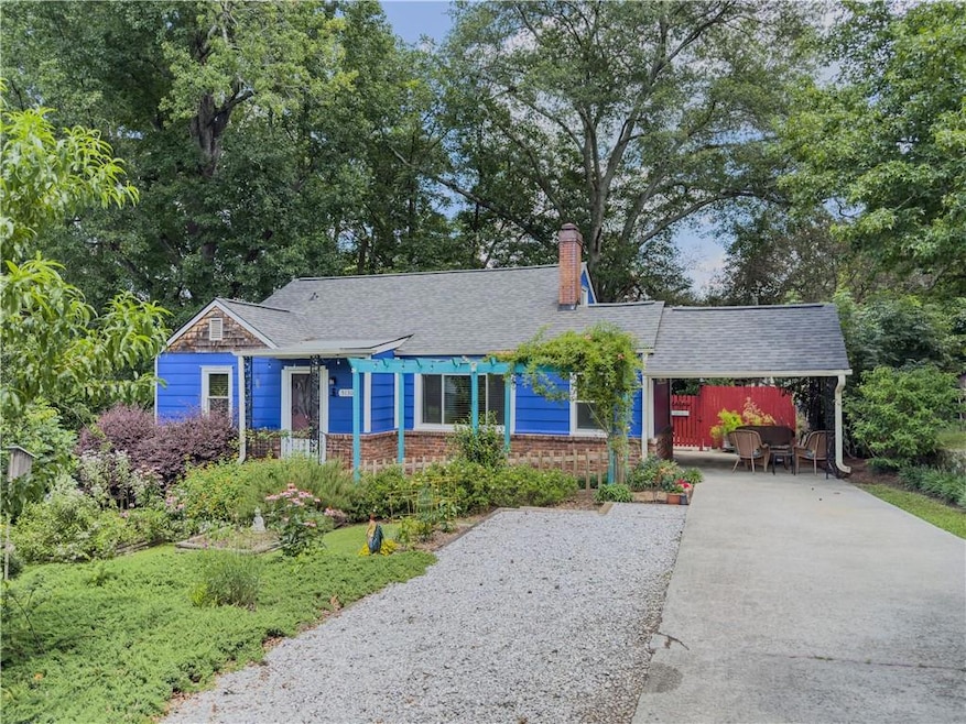
5130 N Dearing St NE Covington, GA 30014
Estimated payment $1,842/month
Highlights
- Green Roof
- Wood Burning Stove
- Attic
- Eastside High School Rated A-
- Wood Flooring
- 1 Fireplace
About This Home
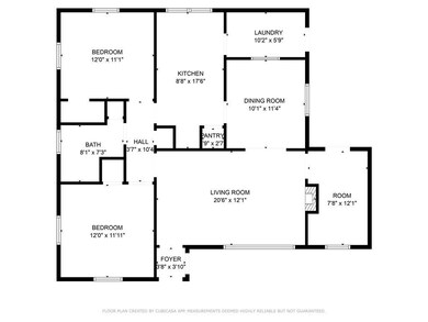
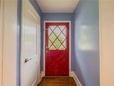
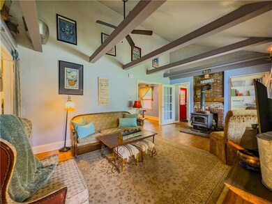
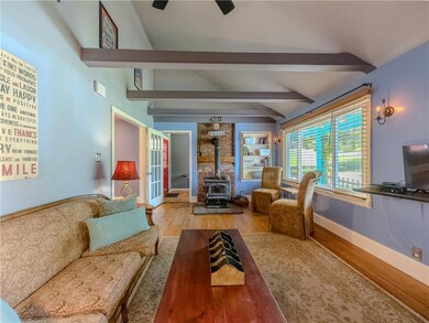
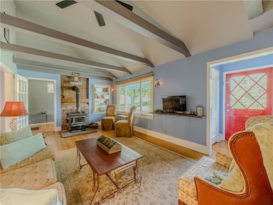
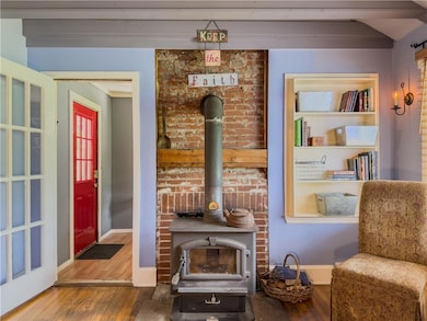
5130 N Dearing Street | Covington, GA Charming, updated, and walkable to downtown Covington — this cozy 2-bedroom, 1-bath home is perfect for first-time buyers or anyone looking to simplify without giving up comfort or character. Step inside and feel right at home in the inviting living room, where a wood-burning stove sets the tone for movie nights and quiet evenings. The kitchen and dining area flow easily together, creating a warm space for everyday meals and friendly gatherings. Two well-sized bedrooms and a full bath make the layout both functional and comfortable, while thoughtful details like the original phone nook and built-in ironing board add a touch of vintage charm. Outside, enjoy peaceful mornings on your private patio or tend to the garden surrounded by manicured landscaping. A covered carport, utility room, and recent updates, including new HVAC, roof, windows, and ductwork - make this home move-in ready. All just minutes from Covington Square’s shops, restaurants, and local favorites — this is small-town living at its best! Schedule your private showing today and start your next chapter at 5130 N Dearing Street.

Home Details
Home Type
- Single Family
Est. Annual Taxes
- $2,212
Year Built
- Built in 1950 | Remodeled
Lot Details
- 10,019 Sq Ft Lot
- Privacy Fence
- Landscaped
- Garden
- Back Yard Fenced
Parking
- 2 Carport Spaces
Home Design
- Cottage
- Bungalow
- Brick Exterior Construction
- Combination Foundation
- Composition Roof
- HardiePlank Type
- Cedar
Interior Spaces
- 1,543 Sq Ft Home
- 1-Story Property
- Beamed Ceilings
- Ceiling Fan
- 1 Fireplace
- Wood Burning Stove
- Double Pane Windows
- Window Treatments
- Living Room
- Formal Dining Room
- Neighborhood Views
- Crawl Space
- Pull Down Stairs to Attic
- Fire and Smoke Detector
Kitchen
- Country Kitchen
- Electric Oven
- Self-Cleaning Oven
- Range Hood
- Dishwasher
- Laminate Countertops
Flooring
- Wood
- Luxury Vinyl Tile
Bedrooms and Bathrooms
- 2 Main Level Bedrooms
- 1 Full Bathroom
- Bathtub and Shower Combination in Primary Bathroom
Laundry
- Laundry in Mud Room
- Laundry Room
- Dryer
- Washer
Eco-Friendly Details
- Green Roof
- Energy-Efficient Appliances
- Energy-Efficient Windows
- Energy-Efficient HVAC
Outdoor Features
- Shed
- Rain Gutters
- Side Porch
Location
- Property is near schools
- Property is near shops
Schools
- East Newton Elementary School
- Cousins Middle School
- Eastside High School
Utilities
- Central Air
- Heating Available
- 110 Volts
- High-Efficiency Water Heater
Listing and Financial Details
- Assessor Parcel Number C009000060005000
Community Details
Recreation
- Trails
Additional Features
- Downtown Subdivision
- Restaurant
Map
Home Values in the Area
Average Home Value in this Area
Tax History
| Year | Tax Paid | Tax Assessment Tax Assessment Total Assessment is a certain percentage of the fair market value that is determined by local assessors to be the total taxable value of land and additions on the property. | Land | Improvement |
|---|---|---|---|---|
| 2024 | $2,246 | $79,520 | $17,200 | $62,320 |
| 2023 | $1,108 | $39,240 | $8,800 | $30,440 |
| 2022 | $1,082 | $36,520 | $8,800 | $27,720 |
| 2021 | $885 | $27,600 | $8,800 | $18,800 |
| 2020 | $994 | $28,200 | $8,800 | $19,400 |
| 2019 | $1,018 | $28,320 | $8,800 | $19,520 |
| 2018 | $973 | $26,920 | $6,000 | $20,920 |
| 2017 | $619 | $18,320 | $2,000 | $16,320 |
| 2016 | $652 | $19,120 | $2,800 | $16,320 |
| 2015 | $574 | $17,200 | $2,000 | $15,200 |
| 2014 | $576 | $17,200 | $0 | $0 |
Property History
| Date | Event | Price | List to Sale | Price per Sq Ft |
|---|---|---|---|---|
| 08/05/2025 08/05/25 | Price Changed | $315,000 | -4.5% | $204 / Sq Ft |
| 06/19/2025 06/19/25 | For Sale | $330,000 | -- | $214 / Sq Ft |
Purchase History
| Date | Type | Sale Price | Title Company |
|---|---|---|---|
| Quit Claim Deed | -- | -- | |
| Deed | $88,000 | -- | |
| Quit Claim Deed | -- | -- |
Mortgage History
| Date | Status | Loan Amount | Loan Type |
|---|---|---|---|
| Previous Owner | $70,400 | New Conventional | |
| Previous Owner | $17,600 | Stand Alone Second | |
| Previous Owner | $65,569 | FHA |
Source: First Multiple Listing Service (FMLS)
MLS Number: 7603064
APN: C009000060005000
Disclaimer: Certain information contained herein is derived from information provided by parties other than Homes.com. All information provided is deemed reliable, but is not guaranteed to be accurate and should be independently verified.
![]() Listings identified with the FMLS IDX logo come from FMLS and are held by brokerage firms other than the owner of this website. The listing brokerage is identified in any listing details. Information is deemed reliable but is not guaranteed. If you believe any FMLS listing contains material that infringes your copyrighted work please visit www.fmls.com/dmca to review our DMCA policy and learn how to submit a takedown request. © 2025 First Multiple Listing Service, Inc.
Listings identified with the FMLS IDX logo come from FMLS and are held by brokerage firms other than the owner of this website. The listing brokerage is identified in any listing details. Information is deemed reliable but is not guaranteed. If you believe any FMLS listing contains material that infringes your copyrighted work please visit www.fmls.com/dmca to review our DMCA policy and learn how to submit a takedown request. © 2025 First Multiple Listing Service, Inc.
- 4105 Rose Ln NE
- 4217 Elizabeth St NE
- 5139 West Dr NE
- 4128 Elizabeth St NE
- 4181 A&B Floyd St NE
- 6127 Floyd St NE
- 5118 Floyd St NE
- 6104 Floyd St NE
- 0 Highway 278 NE Unit 10595588
- 5150 Wheat St NE
- 3127 Mill St SE
- 3149 Thompson Ave SE
- 3112 Floyd St NE
- 3183 Conyers St SE
- 6192 Collins St NE
- 6193 Collins St NE
- 4187 Cherry Laurel Dr SE
- 2173 Anderson Ave SE
- 2133 Thompson Ave SE
- 6104 Blair St NE
- 6234 Collins St NE
- 4152 Baker St NE
- 4511 Sunrise Ridge
- 4068 Ferris Ln
- 4032 Ferris Ln
- 3426 Tallulah Ln
- 160 Heard Ln
- 9300 Delk Rd
- 2238 Emory St SW
- 10235 Waterford Rd NE
- 9207 Golfview Cir
- 6112 Clane Dr SE Unit 6112 Clane Dr
- 6152 Jackson Hwy SW
- 50 Camden Place
- 6107 Shadow Glen Ct SW
- 7125 Puckett St SW
- 6148 Pineneedle Dr SW Unit 6148
- 6372 Avery St SW
- 6360 Avery St SW