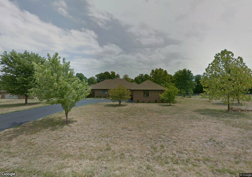
5130 S Westwood Dr Republic, MO 65738
Estimated Value: $406,000 - $455,358
3
Beds
3
Baths
2,260
Sq Ft
$192/Sq Ft
Est. Value
About This Home
This home is located at 5130 S Westwood Dr, Republic, MO 65738 and is currently estimated at $434,453, approximately $192 per square foot. 5130 S Westwood Dr is a home located in Greene County with nearby schools including Schofield Elementary School, Republic Middle School, and Republic High School.
Ownership History
Date
Name
Owned For
Owner Type
Purchase Details
Closed on
May 4, 2022
Sold by
Murphy Barbara J
Bought by
Murphy Lindon D and Murphy Michael J
Current Estimated Value
Purchase Details
Closed on
Sep 7, 2007
Sold by
Woods Glen R and Woods Jean
Bought by
Murphy Jimmy D and Murphy Barbara J
Purchase Details
Closed on
Aug 22, 2005
Sold by
Woods Glen R and Woods Jean
Bought by
Avery Alice and Woods Grant
Create a Home Valuation Report for This Property
The Home Valuation Report is an in-depth analysis detailing your home's value as well as a comparison with similar homes in the area
Home Values in the Area
Average Home Value in this Area
Purchase History
| Date | Buyer | Sale Price | Title Company |
|---|---|---|---|
| Murphy Lindon D | -- | None Listed On Document | |
| Murphy Jimmy D | -- | None Available | |
| Avery Alice | -- | None Available |
Source: Public Records
Tax History Compared to Growth
Tax History
| Year | Tax Paid | Tax Assessment Tax Assessment Total Assessment is a certain percentage of the fair market value that is determined by local assessors to be the total taxable value of land and additions on the property. | Land | Improvement |
|---|---|---|---|---|
| 2025 | $2,476 | $51,330 | $7,900 | $43,430 |
| 2024 | $2,476 | $47,350 | $6,900 | $40,450 |
| 2023 | $2,426 | $47,350 | $6,900 | $40,450 |
| 2022 | $2,290 | $44,540 | $6,900 | $37,640 |
| 2021 | $2,290 | $44,540 | $6,900 | $37,640 |
| 2020 | $1,815 | $34,700 | $6,900 | $27,800 |
| 2019 | $1,807 | $34,700 | $6,900 | $27,800 |
| 2018 | $1,808 | $33,610 | $6,900 | $26,710 |
| 2017 | $1,793 | $32,110 | $6,900 | $25,210 |
| 2016 | $1,728 | $32,110 | $6,900 | $25,210 |
| 2015 | $1,727 | $32,110 | $6,900 | $25,210 |
| 2014 | $1,663 | $30,610 | $6,900 | $23,710 |
Source: Public Records
Map
Nearby Homes
- 135 N Bonnie Ave
- 1021 W Crestview Ln
- 000 W Crestview Ln
- 347 W Elm St
- 1135 W Broad St
- 626 N Phelps Ave
- 520 N College Ave
- 532 N College Ave
- 473 S Michelle Ave
- 707 N College Ave
- 511 S Concordia Ave
- 573 S Charlotte Ct
- 552 S Michelle Ave
- 533 N Main St
- 530 Ashley St
- 0 Highway 60 Unit 60308100
- 0 Highway 60 Unit 60308095
- .94+/- Ac Highway 60
- 2450 Highway 60
- 1213 N London Place
- 5170 S Westwood Dr
- 5151 S Westwood Dr
- 5115 S Westwood Dr
- 5185 S Westwood Dr
- 5080 S Westwood Dr
- 5075 S Westwood Dr
- 769 W Juan Tabo Ln
- 747 W Juan Tabo Ln
- 393 N Tierra Dr
- 5030 S Westwood Dr
- 725 W Juan Tabo Ln
- 375 N Tierra Dr
- 703 W Juan Tabo Ln
- 357 N Tierra Dr
- 392 N Tierra Dr
- 374 N Tierra Dr
- 702 W Juan Tabo Ln
- 339 N Tierra Dr
- 356 N Tierra Dr
- 689 W Juan Tabo Ln