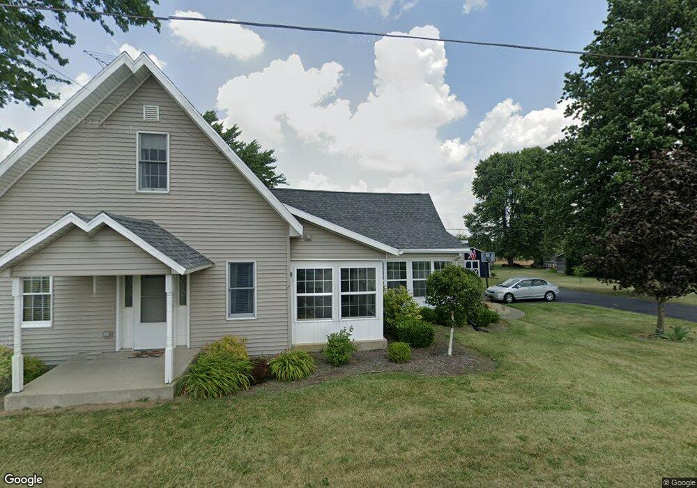
5130 State Route 613 Mc Comb, OH 45858
McComb NeighborhoodEstimated Value: $152,000 - $177,145
3
Beds
2
Baths
1,585
Sq Ft
$103/Sq Ft
Est. Value
About This Home
This home is located at 5130 State Route 613, Mc Comb, OH 45858 and is currently estimated at $164,036, approximately $103 per square foot. 5130 State Route 613 is a home located in Hancock County with nearby schools including McComb Elementary School, McComb Middle School, and Mccomb Local High School.
Ownership History
Date
Name
Owned For
Owner Type
Purchase Details
Closed on
Nov 16, 1992
Bought by
Davis Scott C and Armbrecht Sheri A
Current Estimated Value
Purchase Details
Closed on
Sep 9, 1992
Bought by
Dennis Donna Mae
Purchase Details
Closed on
Apr 29, 1981
Bought by
Winkle Bernice G
Create a Home Valuation Report for This Property
The Home Valuation Report is an in-depth analysis detailing your home's value as well as a comparison with similar homes in the area
Home Values in the Area
Average Home Value in this Area
Purchase History
| Date | Buyer | Sale Price | Title Company |
|---|---|---|---|
| Davis Scott C | -- | -- | |
| Dennis Donna Mae | -- | -- | |
| Winkle Bernice G | -- | -- |
Source: Public Records
Tax History
| Year | Tax Paid | Tax Assessment Tax Assessment Total Assessment is a certain percentage of the fair market value that is determined by local assessors to be the total taxable value of land and additions on the property. | Land | Improvement |
|---|---|---|---|---|
| 2024 | $1,223 | $36,960 | $7,490 | $29,470 |
| 2023 | $1,215 | $36,960 | $7,490 | $29,470 |
| 2022 | $1,250 | $36,960 | $7,490 | $29,470 |
| 2021 | $1,006 | $26,320 | $7,490 | $18,830 |
| 2020 | $1,002 | $26,320 | $7,490 | $18,830 |
| 2019 | $955 | $26,320 | $7,490 | $18,830 |
| 2018 | $814 | $23,660 | $6,510 | $17,150 |
| 2017 | $410 | $23,660 | $6,510 | $17,150 |
| 2016 | $1,143 | $23,660 | $6,510 | $17,150 |
| 2015 | $731 | $22,520 | $5,210 | $17,310 |
| 2014 | $730 | $21,610 | $5,210 | $16,400 |
| 2012 | $757 | $21,610 | $5,210 | $16,400 |
Source: Public Records
Map
Nearby Homes
- 257 S Main St
- 0 Joshua Rd Unit 6126475
- 223 Cherry St
- 4609 Township Road 235
- 4134 County Road 203
- 3111 Township Road 93
- 4014 County Road 139
- 1128 County Road 139
- 7780 Township Road 89
- 358 State Route 613
- 0 Rock Candy Rd Unit Lot 159
- 0 Rock Candy Rd Unit Lot 170
- 0 Rock Candy Rd Unit Lot 172 206819
- 0 Rock Candy Rd Unit Lot 162
- 0 Rock Candy Rd Unit Lot 171
- 0 Rock Candy Rd Unit Lot 168
- 9894 Smokies Way
- 0 Rock Candy Rd Or Bushwillow Dr Unit Lot 173
- 0 Bearcat Way Or Rock Candy Rd Unit Lot 167
- 0 Bushwillow Dr Or Rock Candy Rd Unit Lot 157
- 5118 State Route 613
- 5118 Ohio 613
- 0 E Main St
- 5092 State Route 613
- 5240 Ohio 613
- 5240 State Route 613
- 5081 Ohio 613
- 5081 State Route 613
- 217 Park Dr N
- 105 Park Dr N
- 113 Park Dr N
- 125 Park Dr N
- 211 Park Dr N
- 105 S Park Dr
- 225 Park Dr N
- 305 E Main St
- 298 E Main St
- 118 Park Dr N
- 120 Park Dr N
- 334 Park Dr N
Your Personal Tour Guide
Ask me questions while you tour the home.