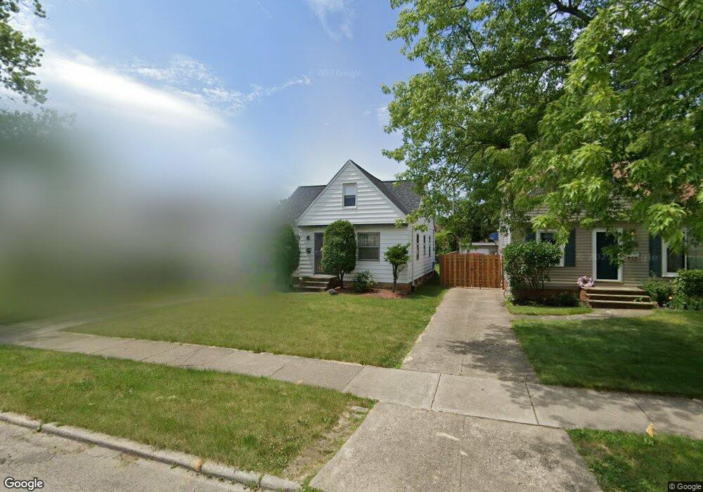
5130 Thomas St Maple Heights, OH 44137
Estimated Value: $102,000 - $163,000
2
Beds
1
Bath
856
Sq Ft
$146/Sq Ft
Est. Value
About This Home
This home is located at 5130 Thomas St, Maple Heights, OH 44137 and is currently estimated at $125,020, approximately $146 per square foot. 5130 Thomas St is a home located in Cuyahoga County with nearby schools including Abraham Lincoln Elementary School, Rockside/ J.F. Kennedy School, and Italy High School.
Ownership History
Date
Name
Owned For
Owner Type
Purchase Details
Closed on
Apr 15, 2013
Sold by
Brumfield Derrick
Bought by
Brumfield Roslyn
Current Estimated Value
Purchase Details
Closed on
Sep 22, 2001
Sold by
Labbee Brian and Labbee Brian J
Bought by
Brumfield Derrick J and Brumfield Roslyn L
Home Financials for this Owner
Home Financials are based on the most recent Mortgage that was taken out on this home.
Original Mortgage
$91,563
Outstanding Balance
$35,653
Interest Rate
6.97%
Mortgage Type
FHA
Estimated Equity
$89,367
Purchase Details
Closed on
Dec 6, 1993
Sold by
Lottig Edward J
Bought by
Labbee Brian J
Purchase Details
Closed on
Dec 14, 1983
Sold by
Lottig Edward J and Lottig Phyllis M
Bought by
Lottig Edward J
Purchase Details
Closed on
Jan 1, 1975
Bought by
Lottig Edward J and Lottig Phyllis M
Create a Home Valuation Report for This Property
The Home Valuation Report is an in-depth analysis detailing your home's value as well as a comparison with similar homes in the area
Home Values in the Area
Average Home Value in this Area
Purchase History
| Date | Buyer | Sale Price | Title Company |
|---|---|---|---|
| Brumfield Roslyn | -- | Attorney | |
| Brumfield Derrick J | $93,000 | Real Estate Title | |
| Labbee Brian J | $64,900 | -- | |
| Lottig Edward J | -- | -- | |
| Lottig Edward J | -- | -- |
Source: Public Records
Mortgage History
| Date | Status | Borrower | Loan Amount |
|---|---|---|---|
| Open | Brumfield Derrick J | $91,563 |
Source: Public Records
Tax History Compared to Growth
Tax History
| Year | Tax Paid | Tax Assessment Tax Assessment Total Assessment is a certain percentage of the fair market value that is determined by local assessors to be the total taxable value of land and additions on the property. | Land | Improvement |
|---|---|---|---|---|
| 2024 | $3,027 | $33,285 | $7,140 | $26,145 |
| 2023 | $2,127 | $19,500 | $4,340 | $15,160 |
| 2022 | $2,120 | $19,500 | $4,340 | $15,160 |
| 2021 | $2,257 | $19,500 | $4,340 | $15,160 |
| 2020 | $1,934 | $14,770 | $3,290 | $11,480 |
| 2019 | $1,923 | $42,200 | $9,400 | $32,800 |
| 2018 | $1,816 | $14,770 | $3,290 | $11,480 |
| 2017 | $1,861 | $13,970 | $3,010 | $10,960 |
| 2016 | $1,800 | $13,970 | $3,010 | $10,960 |
| 2015 | -- | $13,970 | $3,010 | $10,960 |
| 2014 | -- | $15,370 | $3,330 | $12,040 |
Source: Public Records
Map
Nearby Homes
- 5110 Philip Ave
- 5082 Philip Ave
- 5061 Philip Ave
- 5231 Philip Ave
- 5031 Cato St
- 5185 Clement Ave
- 5199 Arch St
- 5208 Clement Ave
- 5257 Philip Ave
- 5239 Arch St
- 5212 Catherine St
- 5234 Erwin St
- 5320 Clement Ave
- 5210 Theodore St
- 17916 North Blvd
- 17912 North Blvd
- 16712 Kollin Ave
- 17806 Maple Heights Blvd
- 17204 Maple Heights Blvd
- 5357 Beechwood Ave
- 5126 Thomas St
- 5134 Thomas St
- 5122 Thomas St
- 5138 Thomas St
- 5118 Thomas St
- 5142 Thomas St
- 5131 Philip Ave
- 5127 Philip Ave
- 5135 Philip Ave
- 5139 Philip Ave
- 5123 Philip Ave
- 5114 Thomas St
- 5144 Thomas St
- 5143 Philip Ave
- 5117 Philip Ave
- 5131 Thomas St
- 5127 Thomas St
- 5135 Thomas St
- 5150 Thomas St
- 5123 Thomas St