Estimated payment $1,681/month
Highlights
- In Ground Pool
- No HOA
- 2 Car Attached Garage
- Sun or Florida Room
- Fenced Yard
- Window Unit Cooling System
About This Home
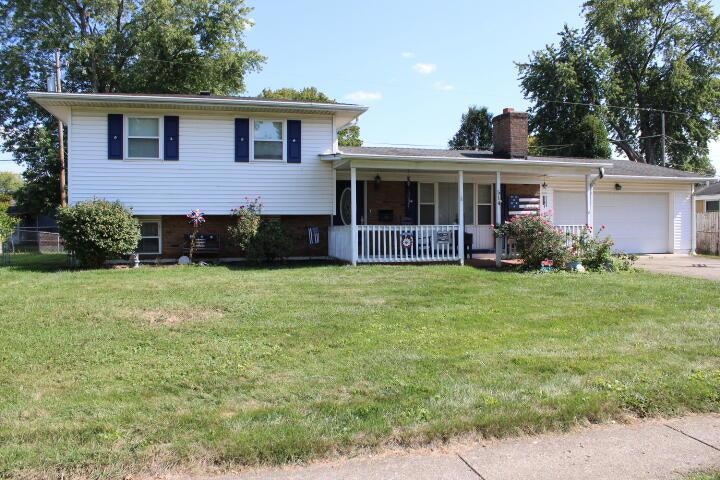
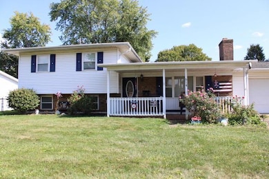
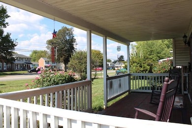
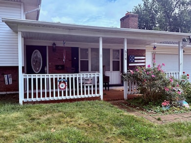
Welcome home to warmth and charm! This Tri-Level 3-bedroom, 1-bath home offers spacious living with a functional layout and fantastic outdoor amenities. The main level features a large living room with a wood-burning fireplace, a large dining area, and a 3 seasons room with insulated windows, perfect for year-round enjoyment close to the kitchen for all your entertaining needs.
Upstairs you'll find three comfortable bedrooms and a full bath with beautiful well cared for natural hardwood floors. The finished lower level adds valuable square footage with flexible space for a rec room, home office, additional living area or additional storage. A two-car garage and whole-home water softener add convenience, while the pantry and abundant closet spaces provide excellent organization.
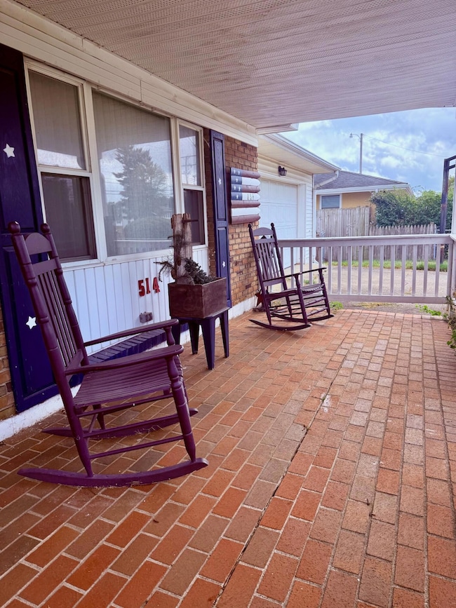
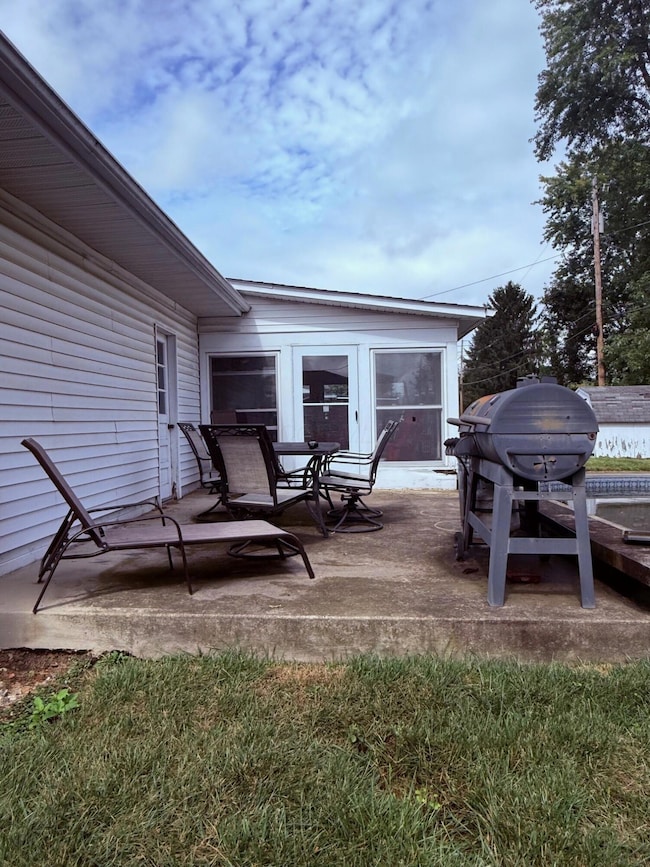
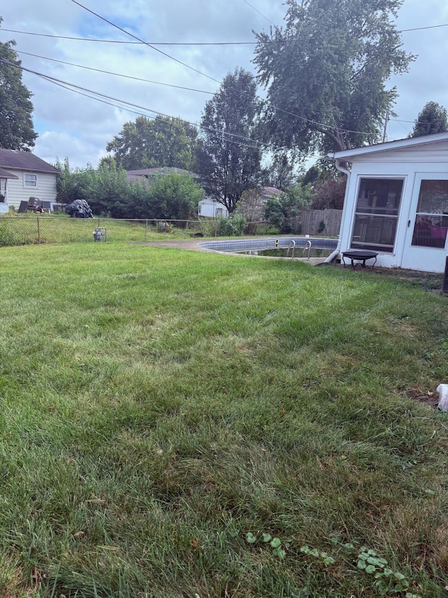
Outside, enjoy the covered front porch, a backyard with an in-ground pool and diving board, and a generous outdoor living patio space ideal for entertaining. Located in Southgate with easy access to local amenities, this home combines comfort, space, and lifestyle.
Schedule your showing today!
Listing Agent
Howard Hanna Real Estate Services License #2021002289 Listed on: 09/25/2025

Open House Schedule
-
Sunday, November 16, 20251:00 to 3:00 pm11/16/2025 1:00:00 PM +00:0011/16/2025 3:00:00 PM +00:00Hosted by April Garske~ Welcome home to warmth and charm! This Tri-Level 3-bedroom, 1-bath home offers spacious living with a functional layout and fantastic outdoor amenities. The main level features a large living room with a wood-burning fireplace, a large dining area, and a 3 seasons room with insulated windows, perfect for year-round enjoyment close to the kitchen for all your entertaining needs. Upstairs you'll find three comfortable bedrooms and a full bath with beautiful well cared for natural hardwood floors. The finished lower level adds valuable square footage with flexible space for a rec room, home office, additional living area or additional storage. A two-car garage and whole-home water softener add convenience, while the pantry and abundant closet spaces provide excellent organization. Outside, enjoy the covered front porch, a backyard with an in-ground pool and diving board, and a generous outdoor living patio space ideal for entertaining. Located in Southgate with easy access to local amenities, this home combines comfort, space, and lifestyle. Schedule your showing today!Add to Calendar
Home Details
Home Type
- Single Family
Est. Annual Taxes
- $3,111
Year Built
- Built in 1966
Lot Details
- 9,583 Sq Ft Lot
- Fenced Yard
Parking
- 2 Car Attached Garage
- Off-Street Parking: 4
Home Design
- Split Level Home
- Tri-Level Property
- Brick Exterior Construction
- Block Foundation
- Vinyl Siding
Interior Spaces
- 1,554 Sq Ft Home
- Wood Burning Fireplace
- Insulated Windows
- Sun or Florida Room
- Laundry on lower level
Kitchen
- Microwave
- Dishwasher
Bedrooms and Bathrooms
- 3 Bedrooms
- 1 Full Bathroom
Basement
- Partial Basement
- Recreation or Family Area in Basement
Outdoor Features
- In Ground Pool
- Patio
- Shed
- Storage Shed
Utilities
- Window Unit Cooling System
- Forced Air Heating System
- Heating System Uses Gas
- Hot Water Heating System
- Water Filtration System
Community Details
- No Home Owners Association
Listing and Financial Details
- Assessor Parcel Number 030-091182-00.000
Map
Home Values in the Area
Average Home Value in this Area
Tax History
| Year | Tax Paid | Tax Assessment Tax Assessment Total Assessment is a certain percentage of the fair market value that is determined by local assessors to be the total taxable value of land and additions on the property. | Land | Improvement |
|---|---|---|---|---|
| 2024 | $3,113 | $72,280 | $15,370 | $56,910 |
| 2023 | $3,445 | $72,280 | $15,370 | $56,910 |
| 2022 | $2,680 | $49,420 | $8,960 | $40,460 |
| 2021 | $2,735 | $49,420 | $8,960 | $40,460 |
| 2020 | $2,753 | $49,420 | $8,960 | $40,460 |
| 2019 | $2,252 | $41,160 | $11,200 | $29,960 |
| 2018 | $2,326 | $0 | $0 | $0 |
| 2017 | $2,325 | $0 | $0 | $0 |
| 2016 | $2,107 | $0 | $0 | $0 |
| 2015 | $2,143 | $0 | $0 | $0 |
| 2014 | $2,946 | $0 | $0 | $0 |
| 2013 | $2,085 | $0 | $0 | $0 |
Property History
| Date | Event | Price | List to Sale | Price per Sq Ft |
|---|---|---|---|---|
| 09/25/2025 09/25/25 | For Sale | $269,900 | -- | $174 / Sq Ft |
Purchase History
| Date | Type | Sale Price | Title Company |
|---|---|---|---|
| Warranty Deed | $125,000 | None Available |
Mortgage History
| Date | Status | Loan Amount | Loan Type |
|---|---|---|---|
| Open | $90,000 | New Conventional |
Source: Columbus and Central Ohio Regional MLS
MLS Number: 225036432
APN: 030-091182-00.000
Disclaimer: Certain information contained herein is derived from information provided by parties other than Homes.com. All information provided is deemed reliable, but is not guaranteed to be accurate and should be independently verified.
![]() IDX information is provided exclusively for personal, non-commercial use, and may not be used for any purpose other than to identify prospective properties consumers may be interested in purchasing.
IDX information is provided exclusively for personal, non-commercial use, and may not be used for any purpose other than to identify prospective properties consumers may be interested in purchasing.
Information is deemed reliable but not guaranteed.
- 521 Partridge Rd
- 39 Cynthia St
- 56 Swainford Dr
- 38 Carey Ln
- 89 Maureen Dr
- 1055 Weiant Ave
- 952 Weiant Ave
- 205 Indianhead Dr
- 171 Cynthia St
- 146 S 31st St
- 235 Cynthia St
- 878 Oberlin Dr
- 909 Fieldson Dr
- 915 W Main St
- 132 Stonington Place Unit 132
- 735 Windsor Ln Unit 735
- 53 Stone House Ct
- 52 N 24th St
- 172 S Williams St
- 1416 Amesbury Ln
- 102 Andover Rd
- 95 S Westmoor Ave
- 537 Huron Dr W Unit D
- 273 Union St
- 1614 Crystal Ct
- 233 S Pine St
- 327 Union St
- 119 Maholm St
- 119 Maholm St
- 1706 Lakeview Dr
- 41 Bowers Ave
- 2010 W Main St
- 79 Weston
- 1372 Londondale Pkwy
- 1420 Londondale Pkwy
- 28 Western Ave Unit 28 Western Ave
- 11 Jefferson St
- 235 Redwood Dr
- 236 Woods Ave Unit A
- 100 Chestnut St