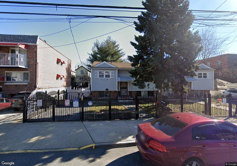
514 Taylor Ave Bronx, NY 10473
Clason Point NeighborhoodEstimated Value: $615,336 - $750,000
Studio
--
Bath
1,694
Sq Ft
$403/Sq Ft
Est. Value
About This Home
This home is located at 514 Taylor Ave, Bronx, NY 10473 and is currently estimated at $682,834, approximately $403 per square foot. 514 Taylor Ave is a home located in Bronx County with nearby schools including P.S. 069 Journey Prep School - X069 and Holy Cross Elementary School.
Ownership History
Date
Name
Owned For
Owner Type
Purchase Details
Closed on
Jun 21, 2001
Sold by
Delleguas Luis and De Lleguas Maria Julia
Bought by
Lopez William and Lopez Ruth
Current Estimated Value
Home Financials for this Owner
Home Financials are based on the most recent Mortgage that was taken out on this home.
Original Mortgage
$199,820
Interest Rate
7.06%
Create a Home Valuation Report for This Property
The Home Valuation Report is an in-depth analysis detailing your home's value as well as a comparison with similar homes in the area
Home Values in the Area
Average Home Value in this Area
Purchase History
| Date | Buyer | Sale Price | Title Company |
|---|---|---|---|
| Lopez William | -- | -- |
Source: Public Records
Mortgage History
| Date | Status | Borrower | Loan Amount |
|---|---|---|---|
| Previous Owner | Lopez William | $199,820 |
Source: Public Records
Tax History
| Year | Tax Paid | Tax Assessment Tax Assessment Total Assessment is a certain percentage of the fair market value that is determined by local assessors to be the total taxable value of land and additions on the property. | Land | Improvement |
|---|---|---|---|---|
| 2025 | $5,426 | $28,637 | $6,814 | $21,823 |
| 2024 | $5,426 | $27,017 | $7,009 | $20,008 |
| 2023 | $5,176 | $25,488 | $7,078 | $18,410 |
| 2022 | $4,959 | $33,120 | $9,480 | $23,640 |
| 2021 | $5,228 | $28,740 | $9,480 | $19,260 |
| 2020 | $5,051 | $26,700 | $9,480 | $17,220 |
| 2019 | $4,710 | $26,340 | $9,480 | $16,860 |
| 2018 | $4,330 | $21,240 | $8,694 | $12,546 |
| 2017 | $4,220 | $20,700 | $9,480 | $11,220 |
| 2016 | $4,214 | $21,080 | $8,584 | $12,496 |
| 2015 | $2,352 | $19,887 | $7,873 | $12,014 |
| 2014 | $2,352 | $18,762 | $8,918 | $9,844 |
Source: Public Records
Map
Nearby Homes
- 1805 Lacombe Ave
- 533 Underhill Ave
- 439 Thieriot Ave
- 1787 Randall Ave
- 424 Thieriot Ave
- 427 Taylor Ave
- 536 Commonwealth Ave
- 420 Thieriot Ave Unit 2
- 643 Thieriot Ave
- 444 Underhill Ave
- 1907 Lacombe Ave
- 1827 Patterson Ave
- 1815 Patterson Ave
- 1822 Seward Ave
- 1785 Patterson Ave
- 645 Saint Lawrence Ave
- 405 Saint Lawrence Ave
- 1739 Lacombe Ave Unit 1B
- 1731 Lacombe Ave Unit 1B
- 1731 Lacombe Ave Unit 4B
- 520 Taylor Ave
- 510 Taylor Ave
- 522 Taylor Ave Unit 1
- 522 Taylor Ave
- 524 Taylor Ave
- 526 Taylor Ave
- 517 Thieriot Ave
- 515 Thieriot Ave
- 519 Thieriot Ave
- 1823 Lacombe Ave
- 1825 Lacombe Ave
- 513 Thieriot Ave
- 1821 Lacombe Ave
- 521 Thieriot Ave
- 528 Taylor Ave
- 1829 Lacombe Ave
- 523 Thieriot Ave
- 1831 Lacombe Ave
- 530 Taylor Ave
- 525 Thieriot Ave
Your Personal Tour Guide
Ask me questions while you tour the home.