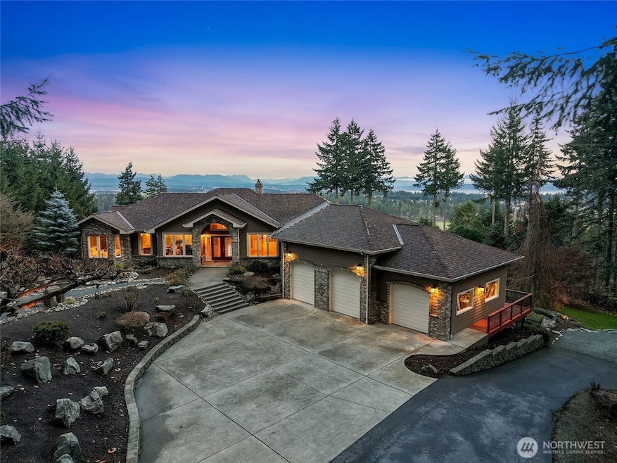
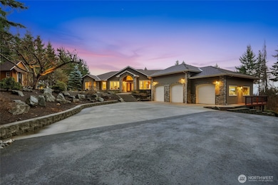
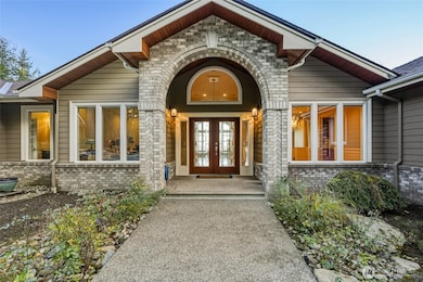
514 Waynes Ridge Cir Camano Island, WA 98282
Estimated payment $9,987/month
Highlights
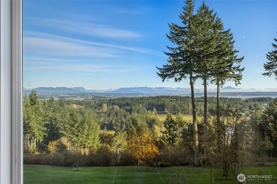
- Ocean View
- Two Primary Bedrooms
- Fruit Trees
- RV Access or Parking
- 2.82 Acre Lot
- Deck
About This Home
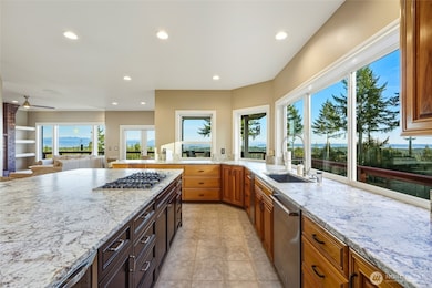
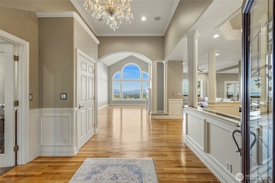
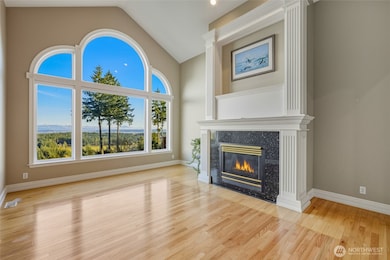
Gorgeous North Camano Private View Acreage Estate Home. Winding paved driveway through old-growth timber & professional landscaping. Custom Quality 5,542sqft modern home w/ updated gourmet-kitchen boasting island w/ prep-sink, dual ovens & stunning views. Vaulted family-room w/ wood fireplace. Covered deck/outdoor living space. Formal fireside living room. 3 bed septic w/ 5 actual "rooms" plus a professional office. Lavish primary-suite w/ spa-bath & two walk-in closets. 2 additional private ensuites, baths attached. Lower bonus room w/ kitchenette and private patio for guests. 1,139sqft attached garage is finished and insulated, plus detached finished office/studio and shed. RV/Boat parking, room for shop. First Time Listed, Welcome Home.
Source: Northwest Multiple Listing Service (NWMLS)
MLS#: 2458080
Home Details
Home Type
- Single Family
Est. Annual Taxes
- $9,260
Year Built
- Built in 1995
Lot Details
- 2.82 Acre Lot
- East Facing Home
- Partially Fenced Property
- Secluded Lot
- Terraced Lot
- Irrigation
- Fruit Trees
- Wooded Lot
- Garden
- Property is in very good condition
Parking
- 3 Car Attached Garage
- Driveway
- RV Access or Parking
Property Views
- Ocean
- Views of a Sound
- Bay
- Lake
- City
- Mountain
Home Design
- Brick Exterior Construction
- Poured Concrete
- Composition Roof
- Metal Roof
- Wood Siding
- Wood Composite
Interior Spaces
- 5,542 Sq Ft Home
- 1-Story Property
- Wet Bar
- Central Vacuum
- Vaulted Ceiling
- Ceiling Fan
- Skylights
- 3 Fireplaces
- Wood Burning Fireplace
- Self Contained Fireplace Unit Or Insert
- Gas Fireplace
- French Doors
- Dining Room
- Finished Basement
- Natural lighting in basement
Kitchen
- Walk-In Pantry
- Double Oven
- Stove
- Microwave
- Dishwasher
- Wine Refrigerator
- Trash Compactor
- Disposal
Flooring
- Wood
- Carpet
- Ceramic Tile
- Vinyl Plank
- Vinyl
Bedrooms and Bathrooms
- Double Master Bedroom
- Walk-In Closet
- Bathroom on Main Level
- Hydromassage or Jetted Bathtub
Laundry
- Dryer
- Washer
Home Security
- Home Security System
- Storm Windows
Outdoor Features
- Deck
- Patio
- Outbuilding
Location
- Property is near public transit
- Property is near a bus stop
Schools
- Utsalady Elementary School
- Port Susan Mid Middle School
- Stanwood High School
Utilities
- Forced Air Heating and Cooling System
- High Efficiency Heating System
- Heat Pump System
- Heating System Mounted To A Wall or Window
- Generator Hookup
- Propane
- Shared Well
- Water Heater
- Septic Tank
- High Speed Internet
- High Tech Cabling
Community Details
- No Home Owners Association
- North End Subdivision
Listing and Financial Details
- Assessor Parcel Number S838200000100
Map
Home Values in the Area
Average Home Value in this Area
Tax History
| Year | Tax Paid | Tax Assessment Tax Assessment Total Assessment is a certain percentage of the fair market value that is determined by local assessors to be the total taxable value of land and additions on the property. | Land | Improvement |
|---|---|---|---|---|
| 2025 | $9,260 | $1,257,101 | $425,000 | $832,101 |
| 2024 | $9,713 | $1,262,470 | $420,000 | $842,470 |
| 2023 | $9,713 | $1,272,837 | $420,000 | $852,837 |
| 2022 | $7,977 | $1,078,558 | $370,000 | $708,558 |
| 2021 | $8,104 | $863,817 | $240,000 | $623,817 |
| 2020 | $8,062 | $850,682 | $240,000 | $610,682 |
| 2019 | $7,578 | $835,898 | $300,000 | $535,898 |
| 2018 | $7,486 | $787,509 | $250,000 | $537,509 |
| 2017 | $5,555 | $720,725 | $180,000 | $540,725 |
| 2016 | $5,608 | $593,674 | $120,000 | $473,674 |
| 2015 | -- | $576,468 | $96,720 | $479,748 |
| 2013 | -- | $588,614 | $96,720 | $491,894 |
Property History
| Date | Event | Price | List to Sale | Price per Sq Ft |
|---|---|---|---|---|
| 12/03/2025 12/03/25 | For Sale | $1,750,000 | -- | $316 / Sq Ft |
Purchase History
| Date | Type | Sale Price | Title Company |
|---|---|---|---|
| Interfamily Deed Transfer | $369,444 | Lt |
Mortgage History
| Date | Status | Loan Amount | Loan Type |
|---|---|---|---|
| Closed | $330,000 | New Conventional |
Source: Northwest Multiple Listing Service (NWMLS)
MLS Number: 2458080
APN: S8382-00-00010-0
Disclaimer: Certain information contained herein is derived from information provided by parties other than Homes.com. All information provided is deemed reliable, but is not guaranteed to be accurate and should be independently verified.
![]() All data is obtained from various sources and may not have been verified by broker or MLS GRID. Supplied Open House Information is subject to change without notice. All information should be independently reviewed and verified for accuracy. Properties may or may not be listed by the office/agent presenting the information. Listing information is provided by the Northwest Multiple Listing Service (NWMLS). Property information is based on available data that may include MLS information, county records, and other sources. Listings marked with the 3 tree icon and provided by NWMLS. All properties are subject to prior sale or withdrawal. IDX information is provided exclusively for consumers’ personal noncommercial use, that it may not be used for any purpose other than to identify prospective properties consumers may be interested in purchasing, that the data is deemed reliable but is not guaranteed by MLS GRID. ©2025 NWMLS.
All data is obtained from various sources and may not have been verified by broker or MLS GRID. Supplied Open House Information is subject to change without notice. All information should be independently reviewed and verified for accuracy. Properties may or may not be listed by the office/agent presenting the information. Listing information is provided by the Northwest Multiple Listing Service (NWMLS). Property information is based on available data that may include MLS information, county records, and other sources. Listings marked with the 3 tree icon and provided by NWMLS. All properties are subject to prior sale or withdrawal. IDX information is provided exclusively for consumers’ personal noncommercial use, that it may not be used for any purpose other than to identify prospective properties consumers may be interested in purchasing, that the data is deemed reliable but is not guaranteed by MLS GRID. ©2025 NWMLS.
Based on information submitted to the MLS GRID
- 0 Dodge Rd Unit NWM2434435
- 0 Dodge Rd Unit NWM2434437
- 0 xx Nhn Wayne's Ridge Cir
- 441 Windsun Way
- 0 Cambell Dr Unit NWM2331086
- 302 Melrose Dr
- 269 E Lochwood Dr
- 941 Cambell Dr
- 25 Anadar Place
- 474 Stirling Dr
- 980 Marshall Dr
- 375 Glengarry Dr
- 78 Vista Del Mar St
- 1015 Aqua Vista Ln
- 1048 Cassius Ct
- 1 S Camano Dr
- 1107 Puesta Del Sol Ave
- 105 N Sunrise Blvd
- 362 N Sunrise Blvd
- 92 Utsalady Rd
- 107 Utsalady Rd
- 654 Lehman Dr
- 1530 Country Club Dr
- 23306 Marine Dr Unit B
- 180 Parker Rd
- 2288 Wagner Rd
- 2279 Elger Park Rd
- 27408 72nd Ave SW
- 26031 72nd Ave NW
- 7110 265th St NW
- 7000 265th St NW
- 6950 282nd Place NW
- 1121 SE Dock St
- 152 NE Midway Blvd
- 275 SE Pioneer Way Unit 100
- 275 SE Pioneer Way Unit 204
- 270 SE Pioneer Way
- 380 SE Barrington Dr
- 5232 300th St NW Unit Upper
- 2801 Huckleberry Ln
