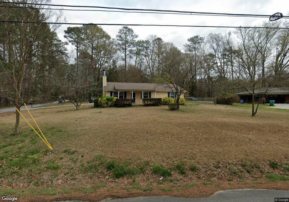
5149 Jones Rd Austell, GA 30106
Estimated Value: $224,000 - $286,821
3
Beds
2
Baths
1,222
Sq Ft
$212/Sq Ft
Est. Value
About This Home
This home is located at 5149 Jones Rd, Austell, GA 30106 and is currently estimated at $258,455, approximately $211 per square foot. 5149 Jones Rd is a home located in Cobb County with nearby schools including Austell Elementary School, Garrett Middle School, and South Cobb High School.
Ownership History
Date
Name
Owned For
Owner Type
Purchase Details
Closed on
May 18, 2009
Sold by
Bank Of New York Mellon
Bought by
Peterson Anne
Current Estimated Value
Purchase Details
Closed on
Mar 4, 2009
Sold by
Hinds Jeremy W
Bought by
Bank Of New York Mellon
Purchase Details
Closed on
Jun 9, 2005
Sold by
Blair Pamela
Bought by
Hinds Jeremy W
Home Financials for this Owner
Home Financials are based on the most recent Mortgage that was taken out on this home.
Original Mortgage
$93,350
Interest Rate
7.99%
Mortgage Type
New Conventional
Purchase Details
Closed on
Apr 27, 1994
Sold by
Newton Keith
Bought by
Beek Pamela M
Home Financials for this Owner
Home Financials are based on the most recent Mortgage that was taken out on this home.
Original Mortgage
$61,963
Interest Rate
7.81%
Mortgage Type
FHA
Create a Home Valuation Report for This Property
The Home Valuation Report is an in-depth analysis detailing your home's value as well as a comparison with similar homes in the area
Home Values in the Area
Average Home Value in this Area
Purchase History
| Date | Buyer | Sale Price | Title Company |
|---|---|---|---|
| Peterson Anne | $50,000 | -- | |
| Bank Of New York Mellon | $44,965 | -- | |
| Hinds Jeremy W | $116,700 | -- | |
| Beek Pamela M | $61,900 | -- |
Source: Public Records
Mortgage History
| Date | Status | Borrower | Loan Amount |
|---|---|---|---|
| Previous Owner | Hinds Jeremy W | $93,350 | |
| Previous Owner | Beek Pamela M | $61,963 |
Source: Public Records
Tax History
| Year | Tax Paid | Tax Assessment Tax Assessment Total Assessment is a certain percentage of the fair market value that is determined by local assessors to be the total taxable value of land and additions on the property. | Land | Improvement |
|---|---|---|---|---|
| 2025 | $1,835 | $77,908 | $33,060 | $44,848 |
| 2024 | $1,836 | $77,908 | $33,060 | $44,848 |
| 2023 | $971 | $63,064 | $33,060 | $30,004 |
Source: Public Records
Map
Nearby Homes
- 2232 Warren Dr
- 5238 Jones Rd
- 2136 Perkerson Mill Rd SW
- 6025 Park Wood Ct
- 2650 Park Ave
- 5164 Medford Ln
- 1 Perkerson Mill Rd SW
- 2125 Clay Rd SW
- 2276 Clay Rd SW
- 2331 Weslan Dr
- 4975 Brawner Lake Dr
- 0 Clay Rd
- 5025 Bishops Row SW
- 1959 Oakbluff Dr
- 1943 Arnold Dr
- 4809 Hemlock Dr
- 4747 Nelda Dr
- 2093 Gherry Dr
- 2713 Flintlock Place
- 2705 Flintlock Place
- 5171 Flint Hill Rd
- 5135 Jones Rd Unit C
- 5135 Jones Rd Unit A
- 5135 Jones Rd
- 5121 Lakeview Ct
- 5119 Lakeview Ct
- 5117 Lakeview Ct
- 5115 Lakeview Ct
- 5123 Lakeview Ct
- 5113 Lakeview Ct
- 5127 Flint Hill Rd
- 5109 Lakeview Ct
- LAKEVIEW Lakeview Ct
- 5107 Lakeview Ct
- 5132 Jones Rd
- 5125 Jones Rd
- 5185 Flint Hill Rd
- 5185 Flint Hill Rd SW
- 5125 Lakeview Ct
- 5125 Jones Rd Unit A&B
Your Personal Tour Guide
Ask me questions while you tour the home.