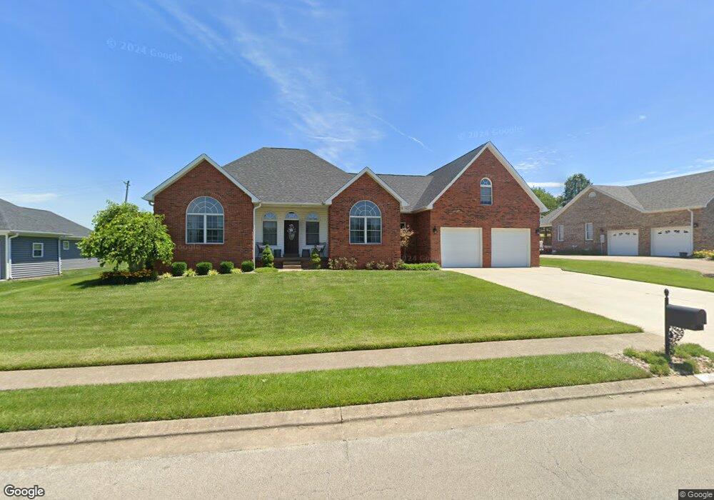
515 Saint Andrews Dr Vine Grove, KY 40175
Estimated Value: $333,000 - $405,000
3
Beds
3
Baths
2,208
Sq Ft
$168/Sq Ft
Est. Value
About This Home
This home is located at 515 Saint Andrews Dr, Vine Grove, KY 40175 and is currently estimated at $370,252, approximately $167 per square foot. 515 Saint Andrews Dr is a home located in Hardin County with nearby schools including Vine Grove Elementary School, James T. Alton Middle School, and North Hardin High School.
Ownership History
Date
Name
Owned For
Owner Type
Purchase Details
Closed on
Jan 10, 2022
Sold by
Dale Cox Arthur and Dale Justin
Bought by
Fogle Joshua S and Fogle Jill A
Current Estimated Value
Purchase Details
Closed on
Jun 16, 2011
Sold by
Berry David Christopher and Berry Kristen L
Bought by
Fogle Joshua S and Fogle Jill
Home Financials for this Owner
Home Financials are based on the most recent Mortgage that was taken out on this home.
Original Mortgage
$263,036
Interest Rate
4.71%
Mortgage Type
VA
Purchase Details
Closed on
Mar 22, 2006
Sold by
Beavin John D and Beavin Alison
Bought by
Signature Properties Of Brandenburg Llc
Create a Home Valuation Report for This Property
The Home Valuation Report is an in-depth analysis detailing your home's value as well as a comparison with similar homes in the area
Home Values in the Area
Average Home Value in this Area
Purchase History
| Date | Buyer | Sale Price | Title Company |
|---|---|---|---|
| Fogle Joshua S | $110,000 | Pike Law Psc | |
| Fogle Joshua S | $257,500 | Kentuckiana Title Agency Llc | |
| Signature Properties Of Brandenburg Llc | -- | None Available |
Source: Public Records
Mortgage History
| Date | Status | Borrower | Loan Amount |
|---|---|---|---|
| Previous Owner | Fogle Joshua S | $263,036 |
Source: Public Records
Tax History Compared to Growth
Tax History
| Year | Tax Paid | Tax Assessment Tax Assessment Total Assessment is a certain percentage of the fair market value that is determined by local assessors to be the total taxable value of land and additions on the property. | Land | Improvement |
|---|---|---|---|---|
| 2024 | $2,635 | $282,900 | $34,500 | $248,400 |
| 2023 | $3,067 | $282,900 | $34,500 | $248,400 |
| 2022 | $2,662 | $282,900 | $34,500 | $248,400 |
| 2021 | $3,125 | $282,900 | $31,400 | $251,500 |
| 2020 | $3,151 | $282,900 | $31,400 | $251,500 |
| 2019 | $0 | $282,900 | $0 | $0 |
| 2018 | $3,076 | $282,900 | $0 | $0 |
| 2017 | $3,027 | $279,700 | $0 | $0 |
| 2016 | $0 | $279,700 | $0 | $0 |
| 2015 | $2,249 | $257,500 | $0 | $0 |
| 2012 | -- | $257,500 | $0 | $0 |
Source: Public Records
Map
Nearby Homes
- 203 Creekvale Ct
- 900 Edgebrook Dr
- 155 Sawgrass Ave
- 26 Sawgrass Ave
- 24 Sawgrass Ave
- 14 Sawgrass Ave
- 86 Sawgrass Ave
- 27 Sawgrass Ave
- 23 Sawgrass Ave
- 13 Sawgrass Ave
- 15 Sawgrass Ave
- 405 Turnberry Ct
- Lot 17 Sawgrass Ave
- Lot 11 Sawgrass Ave
- Lot 10 Sawgrass Ave
- Lot 94 Royal Birkdale Ct
- 109 Debbie Dr
- 230 Royal Birkdale Ct
- 586 Pinehurst Dr
- 584 Pinehurst Dr
- 517 Saint Andrews Dr
- 518 Saint Andrews Dr
- 514 Saint Andrews Dr
- 519 Saint Andrews Dr
- 511 Saint Andrews Dr
- 513 Saint Andrews Dr
- 520 Saint Andrews Dr
- 521 Saint Andrews Dr
- 510 Saint Andrews Dr
- 522 Saint Andrews Dr
- 524 Saint Andrews Dr
- 509 Saint Andrews Dr
- 508 Saint Andrews Dr
- 508 St Andrews Dr
- 526 Saint Andrews Dr
- 525 Saint Andrews Dr
- 507 St Andrews Dr
- 507 Saint Andrews Dr
- 506 Saint Andrews Dr
- 527 Saint Andrews Dr