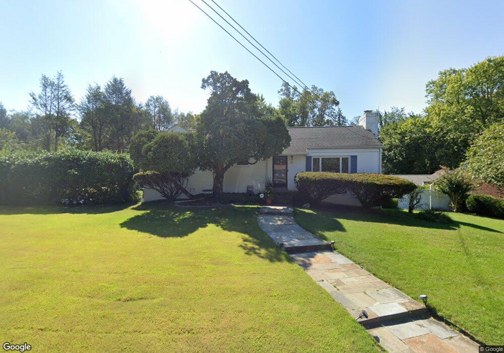
515 Southwest Dr Silver Spring, MD 20901
Estimated Value: $509,000 - $632,122
--
Bed
2
Baths
1,302
Sq Ft
$440/Sq Ft
Est. Value
About This Home
This home is located at 515 Southwest Dr, Silver Spring, MD 20901 and is currently estimated at $573,531, approximately $440 per square foot. 515 Southwest Dr is a home located in Montgomery County with nearby schools including Roscoe R. Nix Elementary School, Cresthaven Elementary School, and Francis Scott Key Middle School.
Ownership History
Date
Name
Owned For
Owner Type
Purchase Details
Closed on
Jul 24, 2019
Sold by
Tadej Peggy L
Bought by
Hafner Jeffrey and Tadej Peggy L
Current Estimated Value
Purchase Details
Closed on
Oct 13, 2011
Sold by
Tanej Peggy L and Tesfaye Dawit
Bought by
Tadej Peggy L
Home Financials for this Owner
Home Financials are based on the most recent Mortgage that was taken out on this home.
Original Mortgage
$269,000
Outstanding Balance
$181,868
Interest Rate
3.92%
Mortgage Type
New Conventional
Estimated Equity
$391,663
Purchase Details
Closed on
Oct 9, 1996
Sold by
A Jeffrey R and A J Brister M
Bought by
Tadej Peggy L and Tesfaye Dawit
Create a Home Valuation Report for This Property
The Home Valuation Report is an in-depth analysis detailing your home's value as well as a comparison with similar homes in the area
Home Values in the Area
Average Home Value in this Area
Purchase History
| Date | Buyer | Sale Price | Title Company |
|---|---|---|---|
| Hafner Jeffrey | -- | None Available | |
| Tadej Peggy L | -- | None Available | |
| Tadej Peggy L | $205,000 | -- |
Source: Public Records
Mortgage History
| Date | Status | Borrower | Loan Amount |
|---|---|---|---|
| Open | Tadej Peggy L | $269,000 |
Source: Public Records
Tax History Compared to Growth
Tax History
| Year | Tax Paid | Tax Assessment Tax Assessment Total Assessment is a certain percentage of the fair market value that is determined by local assessors to be the total taxable value of land and additions on the property. | Land | Improvement |
|---|---|---|---|---|
| 2025 | $5,786 | $472,233 | -- | -- |
| 2024 | $5,786 | $433,167 | $0 | $0 |
| 2023 | $4,615 | $394,100 | $221,700 | $172,400 |
| 2022 | $4,255 | $383,700 | $0 | $0 |
| 2021 | $4,072 | $373,300 | $0 | $0 |
| 2020 | $3,919 | $362,900 | $221,700 | $141,200 |
| 2019 | $3,793 | $359,500 | $0 | $0 |
| 2018 | $3,731 | $356,100 | $0 | $0 |
| 2017 | $3,555 | $352,700 | $0 | $0 |
| 2016 | -- | $328,500 | $0 | $0 |
| 2015 | $3,417 | $304,300 | $0 | $0 |
| 2014 | $3,417 | $280,100 | $0 | $0 |
Source: Public Records
Map
Nearby Homes
- 500 Burnt Mills Ave
- 11200 Legato Way
- 820 Arrington Dr
- 10708 Woodsdale Dr
- 11006 Childs St
- 10810 Wheeler Dr
- 11135 Lockwood Dr
- 10611 Meadowhill Rd
- 11425 Oak Leaf Dr
- 314 Crescendo Way
- 10802 Blossom Ln
- 207 Whitmoor Terrace
- 121 Whitmoor Terrace
- 129 Lynnmoor Dr
- 1 Schindler Ct
- 10319 Cherry Tree Ln
- 10603 S Dunmoor Dr
- 229 Hannes St
- 10309 Ridgemoor Dr
- 905 Playford Ln
- 513 Southwest Dr
- 521 Northwest Dr
- 511 Southwest Dr
- 507 Northwest Dr
- 512 Northwest Dr
- 508 Northwest Dr
- 527 Northwest Dr
- 516 Northwest Dr
- 509 Southwest Dr
- 504 Northwest Dr
- 602 Burnt Mills Ave
- 600 Burnt Mills Ave
- 520 Northwest Dr
- 500 Southwest Dr
- 604 Burnt Mills Ave
- 508 Burnt Mills Ave
- 501 Northwest Dr
- 505 Southwest Dr
- 11001 Abbey Station Ln
- 506 Burnt Mills Ave