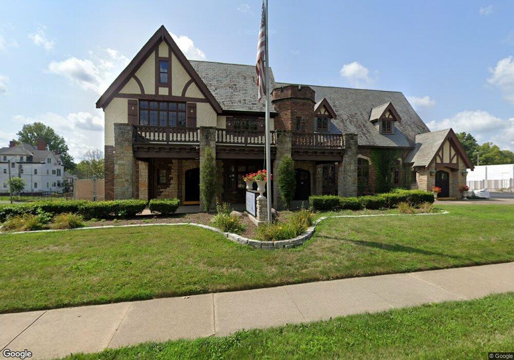
515 W Wood St Decatur, IL 62522
Near West NeighborhoodEstimated Value: $230,575
--
Bed
4
Baths
--
Sq Ft
0.83
Acres
About This Home
This home is located at 515 W Wood St, Decatur, IL 62522 and is currently estimated at $230,575. 515 W Wood St is a home located in Macon County with nearby schools including Dennis Lab School, St. Patrick School, and Teen Challenge-Home For Girls.
Ownership History
Date
Name
Owned For
Owner Type
Purchase Details
Closed on
Apr 9, 2024
Sold by
Dawson & Wikoff Funeral Directors Llc
Bought by
Fox-Mizell Lakeshia
Current Estimated Value
Home Financials for this Owner
Home Financials are based on the most recent Mortgage that was taken out on this home.
Original Mortgage
$247,500
Outstanding Balance
$238,918
Interest Rate
6.88%
Mortgage Type
New Conventional
Estimated Equity
-$8,343
Purchase Details
Closed on
Sep 1, 2004
Create a Home Valuation Report for This Property
The Home Valuation Report is an in-depth analysis detailing your home's value as well as a comparison with similar homes in the area
Home Values in the Area
Average Home Value in this Area
Purchase History
| Date | Buyer | Sale Price | Title Company |
|---|---|---|---|
| Fox-Mizell Lakeshia | $200,000 | None Listed On Document | |
| -- | $810,000 | -- |
Source: Public Records
Mortgage History
| Date | Status | Borrower | Loan Amount |
|---|---|---|---|
| Open | Fox-Mizell Lakeshia | $247,500 |
Source: Public Records
Tax History Compared to Growth
Tax History
| Year | Tax Paid | Tax Assessment Tax Assessment Total Assessment is a certain percentage of the fair market value that is determined by local assessors to be the total taxable value of land and additions on the property. | Land | Improvement |
|---|---|---|---|---|
| 2024 | $6,454 | $66,667 | $25,000 | $41,667 |
| 2023 | $28,839 | $289,765 | $40,976 | $248,789 |
| 2022 | $27,423 | $268,135 | $37,917 | $230,218 |
| 2021 | $25,766 | $250,411 | $35,411 | $215,000 |
| 2020 | $25,392 | $238,786 | $33,767 | $205,019 |
| 2019 | $25,392 | $238,786 | $33,767 | $205,019 |
| 2018 | $25,171 | $239,577 | $33,879 | $205,698 |
| 2017 | $25,764 | $245,972 | $34,783 | $211,189 |
| 2016 | $26,255 | $248,482 | $35,138 | $213,344 |
| 2015 | $24,949 | $244,089 | $34,517 | $209,572 |
| 2014 | $23,167 | $241,672 | $34,175 | $207,497 |
| 2013 | $23,938 | $250,750 | $35,459 | $215,291 |
Source: Public Records
Map
Nearby Homes
- 450 W Macon St
- 440 W Macon St
- 612 W Macon St
- 657 W Wood St
- 617 W Decatur St
- 437 Powers Ln
- 452 W Prairie Ave
- 320 W Main St
- 442 W Prairie Ave
- 717 W Prairie Ave Unit 2
- 233 N Edward St
- 366 W Prairie Ave
- 441 S Seigel St
- 281 W Prairie Ave
- 609 W William St
- 628 W Forest Ave
- 422 W William St
- 254 N Pine St
- 530 Powers Ln
- 330 W William St
- 243 S College St
- 469 W Wood St
- 234 S College St
- 152 S College St
- 548 W Macon St
- 506 W Macon St
- 142 S College St
- 558 W Macon St
- 456 W Wood St
- 462 W Macon St
- 566 W Macon St
- 132 S College St
- 511 W Macon St
- 501 W Macon St
- 545 W Main St
- 605 W Wood St
- 551 W Main St
- 525 W Macon St
- 418 W Wood St
- 563 W Main St