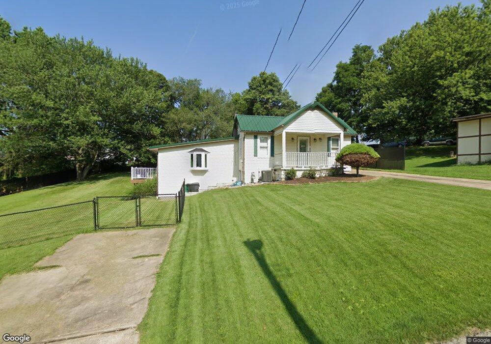
516 Ash St Canonsburg, PA 15317
Estimated Value: $151,658 - $224,000
3
Beds
1
Bath
1,341
Sq Ft
$136/Sq Ft
Est. Value
About This Home
This home is located at 516 Ash St, Canonsburg, PA 15317 and is currently estimated at $182,415, approximately $136 per square foot. 516 Ash St is a home located in Washington County with nearby schools including Canon-Mcmillan Senior High School and Central Christian Academy.
Ownership History
Date
Name
Owned For
Owner Type
Purchase Details
Closed on
May 13, 2014
Sold by
First Fed S & L Assn Greene Cnty
Bought by
Buncic Jason M and Arndt Kara J
Current Estimated Value
Home Financials for this Owner
Home Financials are based on the most recent Mortgage that was taken out on this home.
Original Mortgage
$127,645
Outstanding Balance
$93,202
Interest Rate
3.25%
Mortgage Type
FHA
Estimated Equity
$89,213
Purchase Details
Closed on
Oct 22, 2013
Sold by
Romano Sheriff Samuel F and Evans Arlington E
Bought by
1St Fed S And L Assn Greene Co
Purchase Details
Closed on
Jul 1, 2003
Sold by
Bevec Joseph
Bought by
Evans Carol
Home Financials for this Owner
Home Financials are based on the most recent Mortgage that was taken out on this home.
Original Mortgage
$111,550
Interest Rate
5.53%
Mortgage Type
New Conventional
Create a Home Valuation Report for This Property
The Home Valuation Report is an in-depth analysis detailing your home's value as well as a comparison with similar homes in the area
Home Values in the Area
Average Home Value in this Area
Purchase History
| Date | Buyer | Sale Price | Title Company |
|---|---|---|---|
| Buncic Jason M | $130,000 | -- | |
| 1St Fed S And L Assn Greene Co | -- | -- | |
| Evans Carol | $115,000 | -- |
Source: Public Records
Mortgage History
| Date | Status | Borrower | Loan Amount |
|---|---|---|---|
| Open | Buncic Jason M | $127,645 | |
| Previous Owner | Evans Carol | $111,550 |
Source: Public Records
Tax History Compared to Growth
Tax History
| Year | Tax Paid | Tax Assessment Tax Assessment Total Assessment is a certain percentage of the fair market value that is determined by local assessors to be the total taxable value of land and additions on the property. | Land | Improvement |
|---|---|---|---|---|
| 2025 | $1,486 | $86,900 | $22,700 | $64,200 |
| 2024 | $1,387 | $86,900 | $22,700 | $64,200 |
| 2023 | $1,328 | $83,200 | $22,700 | $60,500 |
| 2022 | $1,324 | $83,200 | $22,700 | $60,500 |
| 2021 | $1,324 | $83,200 | $22,700 | $60,500 |
| 2020 | $1,248 | $83,200 | $22,700 | $60,500 |
| 2019 | $1,227 | $82,600 | $22,700 | $59,900 |
| 2018 | $1,202 | $82,600 | $22,700 | $59,900 |
| 2017 | $268 | $82,600 | $22,700 | $59,900 |
| 2016 | $268 | $7,682 | $644 | $7,038 |
| 2015 | $906 | $7,682 | $644 | $7,038 |
| 2014 | $279 | $7,682 | $644 | $7,038 |
| 2013 | $279 | $7,682 | $644 | $7,038 |
Source: Public Records
Map
Nearby Homes
- 509 Elm St
- 144 Cherry St
- 573 Chesnic Dr
- 121 Sedeca Dr
- 220 Brae Glen Dr
- 111 Chesnic Dr
- 201 Bernstein Ave
- 206 Alexander Ave
- 122 Elm St
- 310 Bow St
- 815 S Central Ave
- Rockford Plan at Magnolia Ridge
- Tucson Plan at Magnolia Ridge
- Truman Plan at Magnolia Ridge
- Birmingham Plan at Magnolia Ridge
- Chattanooga Plan at Magnolia Ridge
- Somerset Plan at Magnolia Ridge
- Boston Plan at Magnolia Ridge
- Waterloo Plan at Magnolia Ridge
- 1100 Greenwood Dr