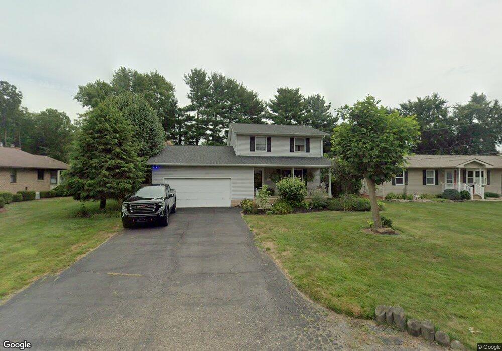
516 Hazel Ave Louisville, OH 44641
Estimated Value: $225,343 - $245,000
3
Beds
2
Baths
1,548
Sq Ft
$152/Sq Ft
Est. Value
About This Home
This home is located at 516 Hazel Ave, Louisville, OH 44641 and is currently estimated at $234,586, approximately $151 per square foot. 516 Hazel Ave is a home located in Stark County with nearby schools including Louisville High School and St. Thomas Aquinas High School & Middle School.
Ownership History
Date
Name
Owned For
Owner Type
Purchase Details
Closed on
Jul 21, 2025
Sold by
Crislip Richard K and Crislip Lisa R
Bought by
Dunn Patrick R and Crislip Kylee N
Current Estimated Value
Home Financials for this Owner
Home Financials are based on the most recent Mortgage that was taken out on this home.
Original Mortgage
$110,000
Outstanding Balance
$109,814
Interest Rate
6.85%
Mortgage Type
New Conventional
Estimated Equity
$124,772
Purchase Details
Closed on
Jan 9, 2004
Sold by
Crislip Richard K
Bought by
Crislip Richard K and Crislip Lisa R
Purchase Details
Closed on
May 16, 1994
Create a Home Valuation Report for This Property
The Home Valuation Report is an in-depth analysis detailing your home's value as well as a comparison with similar homes in the area
Home Values in the Area
Average Home Value in this Area
Purchase History
| Date | Buyer | Sale Price | Title Company |
|---|---|---|---|
| Dunn Patrick R | $225,000 | None Listed On Document | |
| Crislip Richard K | -- | -- | |
| -- | $87,000 | -- |
Source: Public Records
Mortgage History
| Date | Status | Borrower | Loan Amount |
|---|---|---|---|
| Open | Dunn Patrick R | $110,000 |
Source: Public Records
Tax History Compared to Growth
Tax History
| Year | Tax Paid | Tax Assessment Tax Assessment Total Assessment is a certain percentage of the fair market value that is determined by local assessors to be the total taxable value of land and additions on the property. | Land | Improvement |
|---|---|---|---|---|
| 2025 | -- | $60,980 | $14,110 | $46,870 |
| 2024 | -- | $60,980 | $14,110 | $46,870 |
| 2023 | $2,293 | $53,340 | $13,300 | $40,040 |
| 2022 | $2,299 | $53,340 | $13,300 | $40,040 |
| 2021 | $2,308 | $53,410 | $13,300 | $40,110 |
| 2020 | $1,933 | $48,580 | $11,970 | $36,610 |
| 2019 | $1,941 | $48,580 | $11,970 | $36,610 |
| 2018 | $1,934 | $48,580 | $11,970 | $36,610 |
| 2017 | $1,771 | $42,920 | $10,540 | $32,380 |
| 2016 | $1,808 | $42,920 | $10,540 | $32,380 |
| 2015 | $1,813 | $42,920 | $10,540 | $32,380 |
| 2014 | $1,684 | $37,070 | $9,100 | $27,970 |
| 2013 | $846 | $37,070 | $9,100 | $27,970 |
Source: Public Records
Map
Nearby Homes
- 1715 High St
- 1812 E Broad St
- 641 S Nickelplate St
- 308 Superior St
- 520 S Silver St
- 0 Michigan Blvd
- 728 E Broad St
- 2110 Edmar St
- 2015 E Main St
- 204 E Broad St
- 510 S Bauman Ct
- 107 E Broad St
- 325 Lincoln Ave
- 908 Sand Lot Cir
- 1170 Winding Ridge Ave
- 910 Crosswyck Cir
- 3390 Meese Rd NE
- 1702 View Pointe Ave
- 428 Honeycrisp Dr NE
- 3047 Mcintosh Dr NE
- 518 Hazel Ave
- 1606 E Broad St
- 513 S Marion Ave
- 602 Hazel Ave
- 517 Hazel Ave
- 517 Hazel Ave
- 1620 E Broad St
- 505 Hazel Ave
- 525 S Marion Ave
- 614 Hazel Ave
- 521 Hazel Ave
- 603 S Marion Ave
- 0 S Marion Ave Unit 4075814
- 0 S Marion Ave Unit 3768342
- 0 S Marion Ave
- 1508 E Broad St
- 618 Hazel Ave
- 504 S Marion Ave
- 1451 E Broad St
- 520 S Marion Ave