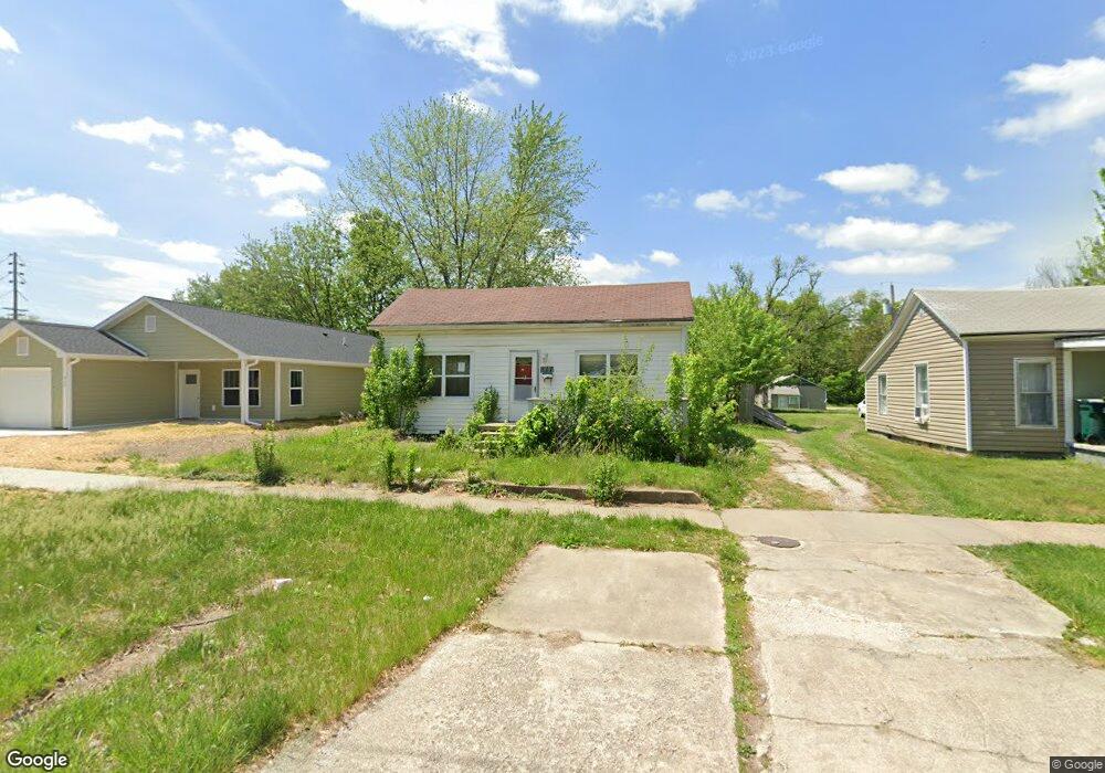
517 N Ault St Moberly, MO 65270
Estimated Value: $63,000 - $92,000
2
Beds
1
Bath
1,035
Sq Ft
$75/Sq Ft
Est. Value
About This Home
This home is located at 517 N Ault St, Moberly, MO 65270 and is currently estimated at $77,204, approximately $74 per square foot. 517 N Ault St is a home located in Randolph County with nearby schools including Moberly Senior High School, St. Pius X. Catholic School, and Maranatha Seventh-day Adventist School.
Ownership History
Date
Name
Owned For
Owner Type
Purchase Details
Closed on
Jun 21, 2024
Sold by
Sumpter Robert Alan
Bought by
Garven Alec Jay
Current Estimated Value
Purchase Details
Closed on
Jan 7, 2021
Sold by
Swank Cheryl L
Bought by
Sumpter Robert A and Sumpter Gary T
Purchase Details
Closed on
Aug 16, 2006
Sold by
Stahlschmidt David P and Stahlschmidt Joyce
Bought by
Swank Cheryl L
Home Financials for this Owner
Home Financials are based on the most recent Mortgage that was taken out on this home.
Original Mortgage
$32,640
Interest Rate
6.79%
Mortgage Type
Future Advance Clause Open End Mortgage
Create a Home Valuation Report for This Property
The Home Valuation Report is an in-depth analysis detailing your home's value as well as a comparison with similar homes in the area
Home Values in the Area
Average Home Value in this Area
Purchase History
| Date | Buyer | Sale Price | Title Company |
|---|---|---|---|
| Garven Alec Jay | -- | None Listed On Document | |
| Sumpter Robert A | $6,841 | None Available | |
| Swank Cheryl L | -- | -- |
Source: Public Records
Mortgage History
| Date | Status | Borrower | Loan Amount |
|---|---|---|---|
| Previous Owner | Swank Cheryl L | $32,640 |
Source: Public Records
Tax History Compared to Growth
Tax History
| Year | Tax Paid | Tax Assessment Tax Assessment Total Assessment is a certain percentage of the fair market value that is determined by local assessors to be the total taxable value of land and additions on the property. | Land | Improvement |
|---|---|---|---|---|
| 2025 | $221 | $3,300 | $981 | $2,319 |
| 2024 | $221 | $3,040 | $854 | $2,186 |
| 2023 | $225 | $3,040 | $854 | $2,186 |
| 2022 | $212 | $2,940 | $856 | $2,084 |
| 2021 | $212 | $2,940 | $856 | $2,084 |
| 2020 | $212 | $2,940 | $856 | $2,084 |
| 2019 | $211 | $2,940 | $856 | $2,084 |
| 2018 | $210 | $2,940 | $856 | $2,084 |
| 2017 | $210 | $2,940 | $0 | $0 |
| 2016 | $168 | $2,360 | $0 | $0 |
| 2014 | -- | $2,290 | $0 | $0 |
| 2013 | -- | $2,290 | $0 | $0 |
| 2012 | -- | $2,260 | $0 | $0 |
Source: Public Records
Map
Nearby Homes
- 812 N Moulton St
- 664 & 668 N Ault St
- 511 Union Ave
- 602 Vincil St
- 531 Farror St
- 101 N Ault St
- 524 Barrow St
- 609 Franklin Ave
- 625 Franklin Ave
- 620 Burkholder St
- 1102 N Morley St
- 216 S 5th St
- 523 Morehead St
- 800 Franklin St
- 720 Saint Charles St
- 428 Woodland Ave
- 815 Myra St
- 837 Myra St
- 319 S 6th St
- 710 W Rollins St