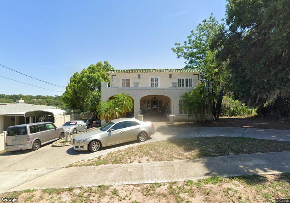
518 Fernshaw Ave Eustis, FL 32726
Estimated Value: $361,152 - $418,000
2
Beds
3
Baths
3,013
Sq Ft
$128/Sq Ft
Est. Value
About This Home
This home is located at 518 Fernshaw Ave, Eustis, FL 32726 and is currently estimated at $384,288, approximately $127 per square foot. 518 Fernshaw Ave is a home located in Lake County with nearby schools including Eustis Elementary School, Eustis Middle School, and Eustis High School.
Ownership History
Date
Name
Owned For
Owner Type
Purchase Details
Closed on
Mar 8, 2005
Sold by
Divenanzo Daniel F and Divenanzo Merrilyn A
Bought by
Demorse Rand and Demorse Justin Daniel
Current Estimated Value
Home Financials for this Owner
Home Financials are based on the most recent Mortgage that was taken out on this home.
Original Mortgage
$140,000
Outstanding Balance
$69,982
Interest Rate
5.6%
Mortgage Type
Unknown
Estimated Equity
$314,306
Purchase Details
Closed on
Jul 24, 1996
Sold by
Chandler Thurman L and Chandler Anne B
Bought by
Divenanzo Daniel F and Divenanzo Merrilyn A
Home Financials for this Owner
Home Financials are based on the most recent Mortgage that was taken out on this home.
Original Mortgage
$92,250
Interest Rate
8.26%
Create a Home Valuation Report for This Property
The Home Valuation Report is an in-depth analysis detailing your home's value as well as a comparison with similar homes in the area
Home Values in the Area
Average Home Value in this Area
Purchase History
| Date | Buyer | Sale Price | Title Company |
|---|---|---|---|
| Demorse Rand | $240,000 | -- | |
| Divenanzo Daniel F | $102,500 | -- |
Source: Public Records
Mortgage History
| Date | Status | Borrower | Loan Amount |
|---|---|---|---|
| Open | Demorse Rand | $140,000 | |
| Previous Owner | Divenanzo Daniel F | $92,250 |
Source: Public Records
Tax History
| Year | Tax Paid | Tax Assessment Tax Assessment Total Assessment is a certain percentage of the fair market value that is determined by local assessors to be the total taxable value of land and additions on the property. | Land | Improvement |
|---|---|---|---|---|
| 2026 | $2,413 | $171,520 | -- | -- |
| 2025 | $2,301 | $166,860 | -- | -- |
| 2024 | $2,301 | $166,860 | -- | -- |
| 2023 | $2,301 | $157,290 | $0 | $0 |
| 2022 | $2,254 | $152,710 | $0 | $0 |
| 2021 | $1,767 | $128,846 | $0 | $0 |
| 2020 | $1,823 | $127,541 | $0 | $0 |
| 2019 | $1,806 | $125,445 | $0 | $0 |
| 2018 | $1,619 | $118,313 | $0 | $0 |
| 2017 | $1,560 | $115,044 | $0 | $0 |
| 2016 | $1,546 | $113,243 | $0 | $0 |
| 2015 | $1,468 | $107,844 | $0 | $0 |
| 2014 | $1,453 | $106,760 | $0 | $0 |
Source: Public Records
Map
Nearby Homes
- 1814 Sellen Dr
- 740 Summit St
- 510 E Key Ave
- 504 Ambassador Ave
- 312 Osceola Ave
- 0 S Mary St
- 206 Osceola Ave
- 922 E Washington Ave
- 1122 Virginia Ct
- 860 S Grove St
- 322 Palm Ave
- 822 Poinsettia Dr
- 1016 E Washington Ave
- 1023 S Morningside Dr
- 1004 Lantana Dr
- 1045 S Morningside Dr
- 110 S Mary St
- 528 E Citrus Ave
- 1033 S Grove St
- 422 E Citrus Ave
- 520 Fernshaw Ave
- 514 Fernshaw Ave
- 600 Lake Gracie Dr
- 717 Summit St Unit 2
- 611 Fernshaw Ave
- 500 Fernshaw Ave
- 517 Fernshaw Ave
- 719 Summit St
- 509 Fernshaw Ave
- 501 Fernshaw Ave
- 735 Summit St
- 433 Fernshaw Ave
- 622 Summit St
- 504 Lake Gracie Dr
- 702 Summit St
- 712 Summit St
- 424 Fernshaw Ave
- 429 Fernshaw Ave
- 720 Summit St
- 765 Summit St
Your Personal Tour Guide
Ask me questions while you tour the home.