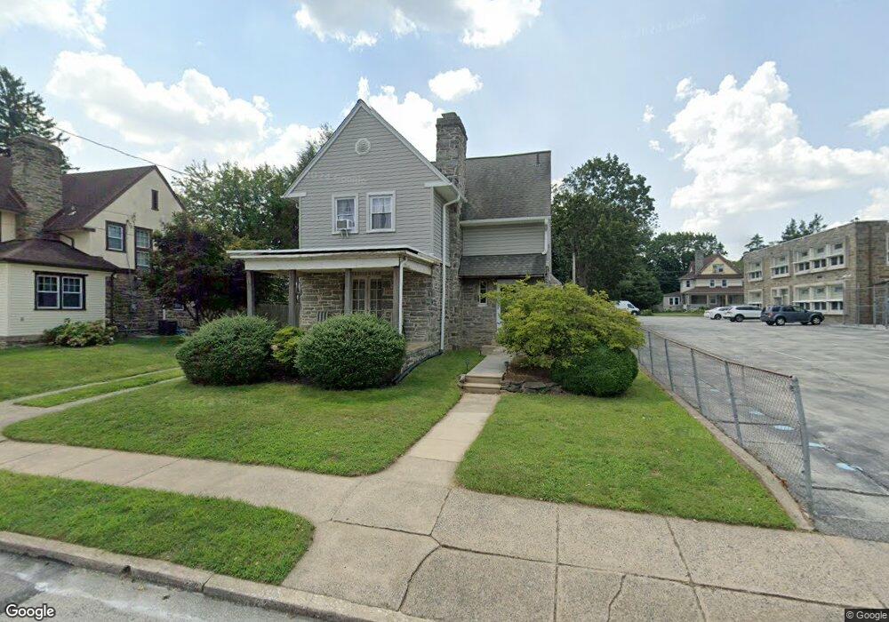
518 Foss Ave Drexel Hill, PA 19026
Estimated Value: $366,000 - $407,000
4
Beds
2
Baths
2,044
Sq Ft
$189/Sq Ft
Est. Value
About This Home
This home is located at 518 Foss Ave, Drexel Hill, PA 19026 and is currently estimated at $386,508, approximately $189 per square foot. 518 Foss Ave is a home located in Delaware County with nearby schools including Hillcrest El School, Drexel Hill Middle School, and Upper Darby High School.
Ownership History
Date
Name
Owned For
Owner Type
Purchase Details
Closed on
Dec 20, 2004
Sold by
Tarpey Evelyn Brannan and Estate Of Evelyn M Brannan
Bought by
Marcellus Mark and Marcellus Regina
Current Estimated Value
Purchase Details
Closed on
Aug 31, 1994
Sold by
Burns Vincent L
Bought by
Brannan Evelyn M
Home Financials for this Owner
Home Financials are based on the most recent Mortgage that was taken out on this home.
Original Mortgage
$90,000
Interest Rate
5.37%
Mortgage Type
Purchase Money Mortgage
Create a Home Valuation Report for This Property
The Home Valuation Report is an in-depth analysis detailing your home's value as well as a comparison with similar homes in the area
Home Values in the Area
Average Home Value in this Area
Purchase History
| Date | Buyer | Sale Price | Title Company |
|---|---|---|---|
| Marcellus Mark | -- | -- | |
| Brannan Evelyn M | $95,000 | Commonwealth Land Title Ins |
Source: Public Records
Mortgage History
| Date | Status | Borrower | Loan Amount |
|---|---|---|---|
| Previous Owner | Brannan Evelyn M | $90,000 |
Source: Public Records
Tax History Compared to Growth
Tax History
| Year | Tax Paid | Tax Assessment Tax Assessment Total Assessment is a certain percentage of the fair market value that is determined by local assessors to be the total taxable value of land and additions on the property. | Land | Improvement |
|---|---|---|---|---|
| 2025 | $7,404 | $175,070 | $43,830 | $131,240 |
| 2024 | $7,404 | $175,070 | $43,830 | $131,240 |
| 2023 | $7,334 | $175,070 | $43,830 | $131,240 |
| 2022 | $7,137 | $175,070 | $43,830 | $131,240 |
| 2021 | $9,623 | $175,070 | $43,830 | $131,240 |
| 2020 | $7,227 | $111,720 | $35,290 | $76,430 |
| 2019 | $7,100 | $111,720 | $35,290 | $76,430 |
| 2018 | $7,018 | $111,720 | $0 | $0 |
| 2017 | $6,836 | $111,720 | $0 | $0 |
| 2016 | $613 | $111,720 | $0 | $0 |
| 2015 | $613 | $111,720 | $0 | $0 |
| 2014 | $613 | $111,720 | $0 | $0 |
Source: Public Records
Map
Nearby Homes
- 3700 School Ln
- 542 Shadeland Ave
- 3634 Rosemont Ave
- 506 Burmont Rd
- 3810 Huey Ave
- 3804 Rosemont Ave
- 3708 Garrett Rd
- 3706 Garrett Rd
- 3811 Berry Ave
- 3419 Valley Green Dr
- 474 Kenwood Rd
- 3765 Highland Ave
- 4014 Rosemont Ave
- 455 Irvington Rd
- 4123 School Ln
- 382 Upland Way
- 4130 Rosemont Ave
- 801 Penn Ave
- 337 Cheswold Rd
- 333 Blanchard Rd